Geology

Geology
The 366 daily episodes in 2014 were chronological snapshots of earth history, beginning with the Precambrian in January and on to the Cenozoic in December. You can find them all in the index in the right sidebar. In 2015, the daily episodes for each month were assembled into monthly packages (link in index at right), and a few new episodes were posted from 2015-18. You may be interested in a continuation of this blog on Substack at this location. Thanks for your interest!
Showing posts with label Plate Tectonics. Show all posts

Tuesday, March 20, 2018

Episode 392 Ophiolites


Today’s episode focuses on one of those wonderful jargon words geologists love to use: Ophiolites.

It’s not a contrived term like cactolith nor some really obscure mineral like pararammelsbergite. Ophiolites are actually really important to our understanding of the concept of plate tectonics and how the earth works dynamically.

The word goes back to 1813 in the Alps, where Alexandre Brongniart coined the word for some scaly, greenish rocks. Ophiolite is a combination of the Greek words for snake and stone, and Brongniart was also a specialist in reptiles. So he named these rocks for their resemblance to snake skins.

Fast forward about 150 years, to the 1960s. Geophysical data, deep-sea sampling, and other work was leading to the understanding that the earth’s crust is fundamentally different beneath the continents and beneath the oceans—and we found that the rocks in the oceanic crust are remarkably similar to the greenish, iron- and magnesium-rich rocks that had been labeled ophiolites long ago and largely ignored except by specialists ever since.

Those rocks that form the oceanic crust include serpentine minerals, which are soft, often fibrous iron-magnesium silicates whose name is yet another reference to their snake-like appearance.  Pillow basalts, iron-rich lava flows that solidify under water with bulbous, pillow-like shapes, are also typical of oceanic crust. The term ophiolite was rejuvenated to apply to a specific sequence of rocks that forms at mid-ocean ridges, resulting in sea-floor spreading and the movement of plates around the earth.

The sequence usually but not always includes some of the most mantle-like minerals, such as olivine, another iron-magnesium silicate, that may settle out in a magma chamber beneath a mid-ocean ridge. Shallower, relatively narrow feeders called dikes toward the top of the magma chamber fed lava flows on the surface – but still underwater, usually – that’s where those pillow lavas solidified.
There are certainly variations, and interactions with water as well as sediment on top of the oceanic crust can complicate things, but on the whole that’s the package. So why not just call it oceanic crust and forget the jargon word ophiolite? Well, we’ve kind of done that, or at least restricted the word to a special case.

Pillow Lava off Hawaii. Source: NOAA. 

The word ophiolite today is usually used to refer to slices or layers of oceanic crust that are on land, on top of continental crust. But wait, you say, you keep saying subduction is driven by oceanic crust, which is denser, diving down beneath continental crust, which is less dense. Well, yes – but I hope I didn’t say always.

Sometimes the circumstances allow for some of the oceanic crust to be pushed up over bits of continental crust, despite their greater density. One area where this seems to happen with some regularity is a setting called back-arc basins, which are areas of extension, pulling-apart, behind the collision zone where oceanic crust and continental crust come together with the oceanic plate mostly subducting, going down under the continental plate. It took some time in the evolution of our understanding of plate tectonics for the idea to come out that you can have significant pulling apart in zones that are fundamentally compression, collision, but they’re recognized in many places today, as well as in the geologic past.

It seems to me that back-arc basins are more likely to develop where the interaction is between plates or sub-plates that are relatively weak, or small, and more susceptible to breaking. An example is where two oceanic plates are interacting, with perhaps only an island arc between them. The “battle” is a closer contest than between a big, strong continent and weaker, warmer, softer, oceanic crust, so slices of one plate of oceanic crust may be squeezed up and onto the rocks making up the island arc. This happens in the southwest Pacific, where the oceanic Pacific Plate and the oceanic part of the Australian Plate are interacting, creating back-arc basins around Tonga and Fiji and elsewhere.
It also happens where continental material is narrower, or thinner, or where the interaction is oblique or complex. One example of this today is the back-arc basin in the Andaman Sea south of Burma, Myanmar, where the Indian Ocean plate is in contact with a narrow prong of continent, Indochina and Malaya.

We’ve now recognized quite a few ophiolites on land, emplaced there long ago geologically. At Gros Morne National Park in Newfoundland, the Bay of Islands ophiolite is of Cambrian to Ordovician age. The area is a UNESCO World Heritage Site for the excellent exposures of oceanic crust there, not to mention fine scenery.

On Cyprus, the Troodos Ophiolite represents breaking within the Tethys Oceanic plate as it was squeezed between Gondwana, or Africa, and the Anatolian block of Eurasia, which is today’s Turkey. The Troodos Ophiolite is rich in copper sulfides that were probably deposited from vents on a mid-ocean ridge. In fact, the name Cyprus is the origin of our word copper, by way of Latin cuprum and earlier cyprium.  

On the island of New Caledonia, east of Australia and in the midst of the messy interactions among tectonic plates large and small, the ophiolite is rich in another metal typical of deep-crust or mantle sources: nickel. There’s enough to make tiny New Caledonia tied with Canada for third place as the world’s largest producer of nickel, after Indonesia and the Philippines.

There’s a huge ophiolite in Oman, the Semail Ophiolite, covering about a hundred thousand square kilometers. It’s one of the most compete examples anywhere, and it was pushed up on to the corner of the Arabian continental block during Cretaceous time, around 80 million years ago. Like the one in Cyprus, this one is also rich in copper as well as chromite, another deep-crustal or mantle-derived mineral.

The Coast Range Ophiolite in California is Jurassic, about 170 million years old, and formed at roughly the same time as the Sierra Nevada Batholith developed as a more standard response to subduction. It’s likely that western North America at that time was somewhat like the southwestern Pacific today, with strings of island arcs, small irregular continental blocks, and diverse styles of interaction – the perfect setting for a long band of oceanic crust to be pushed up and over other material. The whole thing ultimately got amalgamated with the main North American continent. I talked a bit more about these events in the episode on the Franciscan, November 7, 2014.

—Richard I. Gibson
LINKS: 


Tuesday, February 20, 2018

Episode 388 Folds in Algeria


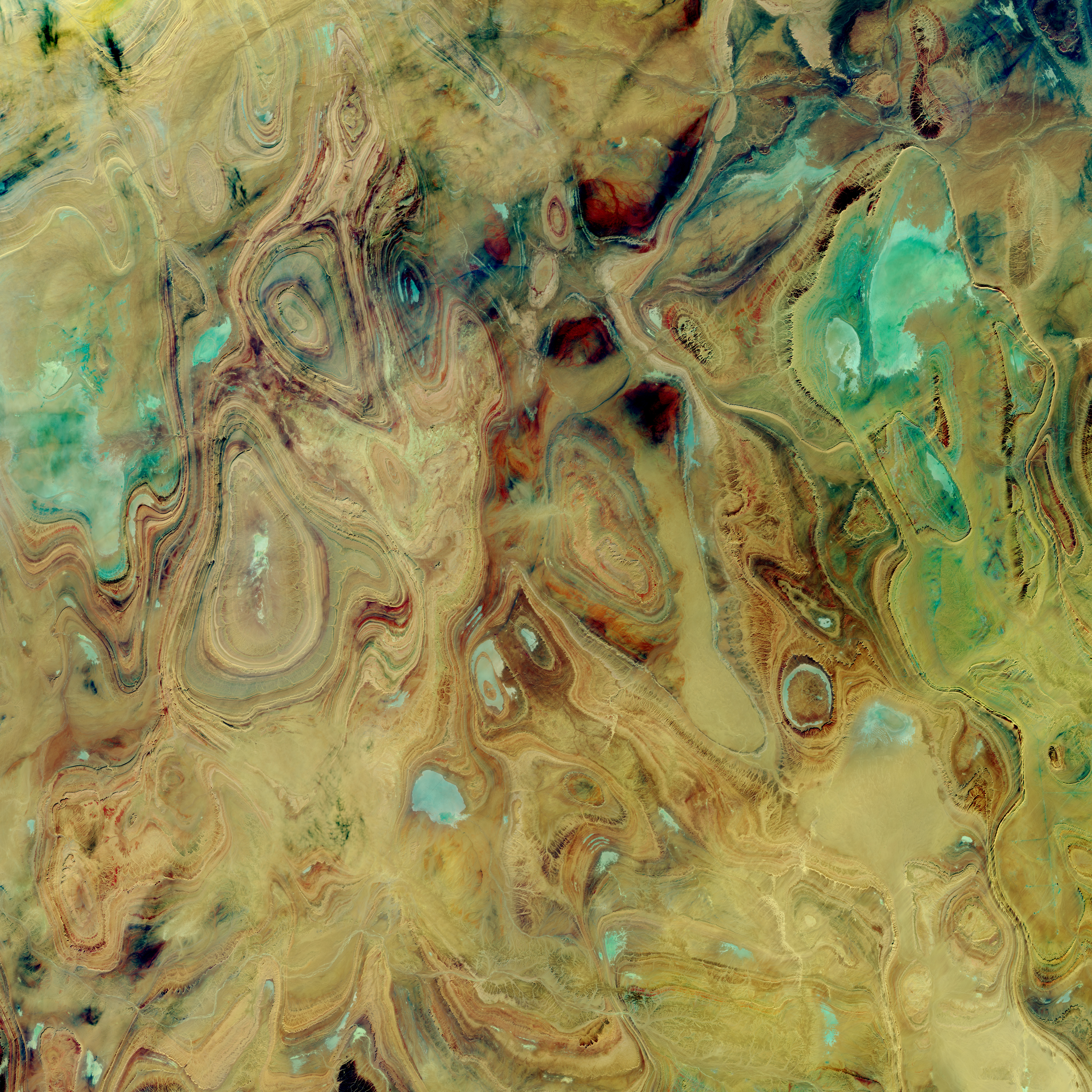
You may have seen some of the spectacular images of the earth in southern Algeria, curves and colors like some Picasso in the opposite of his cubist period. If you haven’t, check out the one from NASA, below. 

The ovals and swirls, with their concentric bands, are immediately obvious to a geologist as patterns of folds, but not just linear folds like many anticlines and synclines form. These closed ovals represent domes and basins – imagine a large scale warping, both up and down, in a thick succession of diverse sedimentary rocks, like sets of nested bowls, some of them right-side up and some inverted, then all sliced off halfway through.

But “obvious to a geologist” has plenty of limitations in a space image. Without knowing more information, it’s difficult to be sure if an oval is a basin or a dome. And you can speculate, but without some ground truth, it’s challenging to be sure what the rock types are.

Ahnet-Mouydir, Hoggar Mountains, Algeria. NASA image - source

This area, called the Ahnet-Mouydir, on the flank of the Hoggar Mountains close to the middle of the Sahara Desert, is remote, inhospitable, and arid, and called the “land of terror” for a reason. The rocks represent a thick sequence of marine sandstones, shales, and limestones, spanning a huge range of ages, from at least the Ordovician to the early Carboniferous – 150 million years or more, a great chunk of the Paleozoic era.


The core of the Hoggar Mountains is an old Precambrian block, not as big as the cratons and shields that form the hearts of most of the continents, but otherwise similar. It might have been something like a microcontinent that became amalgamated into the growing supercontinent of Gondwana about 600 million years ago. After that amalgamation, seas came and went much like they did in western North America throughout much of the Paleozoic era, laying down the sediments that became the rocks we see today in the northern Hoggar Mountains.

That’s all well and good – but here’s the next question, how did the rocks get deformed into these oval domes and basins? If you imagine the kinds of collisions that are typical on earth, you think of linear or curvilinear things – island arcs, edges of continents and such – that when they collide, are likely to make linear belts of deformation. This is why so many mountain ranges are long, linear features, and the folds and faults that make them up also tend to be linear. Domes and basins happen, but that seems to be almost all we have here in these mountains.

We have to look for a deformational event that is later than the youngest rocks deformed. So if some of these rocks are as young as early Carboniferous, about 340 million years old, the mountain-building event that fills the bill is the Hercynian Orogeny, where ‘orogeny’ just means mountain-building.

The Hercynian, at about 350 to 280 million years ago, represents the complex collision between Gondwana and the combined North America and Europe, which were already more or less attached to each other. The leading edge of Gondwana that collided was in what is now North and West Africa, and the collision produced mountain ranges all over – the Alleghenies in the central Appalachians in North America, and a complex swath of mountains across central Europe, from Spain, across France to northern Germany and into Poland, as well as elsewhere. In Africa, the most intense squeezing was at the leading edge, in what is now Morocco and Mauritania, colliding with North America, and northern Algeria, impacting Iberia.

The basins and domes of southern Algeria that we’re trying to understand are 1500 kilometers or more from that leading edge of continental collision. So I think – and full disclosure, I’ve never really researched this area in detail – that what must have happened is that that distant hinterland wasn’t pushed into tight, linear belts like those we find along the lines of collision, but the force was enough to warp the sediments into these relatively small domes and basins. Alternatively, it might be possible that the brittle Precambrian rocks beneath the sedimentary layers broke from the force of the collision, so that the sedimentary layers draped over the deeper brittle surface like a carpet lying over a jumble of toy building blocks – some high, some low.

The latter idea, that the brittle basement rocks were broken and pushed upward with the sedimentary layers draped over them is supported by research published in the journal Terra Nova in 2001. Hamid Haddoum and colleagues studied the orientations of folds and faults in this area, trying to figure out the orientations of the stresses that caused them. Their data show a shortening direction – which means compression, or squeezing – during early Permian time oriented about northeast-southwest. That is consistent with the collision that was happening at that same time between what is now Senegal and Mauritania, in westernmost Africa, and the Virginia-Carolinas region of what is now the United States. Haddoum and his colleagues show cross-sections with basement upthrusts, basically high-angle reverse faults where older rocks are squeezed so much that they are pushed up and over younger rocks. This is quite similar to the Laramide Orogeny in the western United States about 80 to 50 million years ago, but this compression was happening about 280 million years ago as the supercontinent of Pangaea was assembled during the early Permian Period. Both represent deformation at relatively great distances from the lines of continental collision. In the case of the Laramide in western United States, one idea for transmitting the stress so far from the collision is that the subducting slab of oceanic crust began to go down at a relatively gentle angle, even close to horizontal, creating friction and stress further away from the subduction zone than normal. Whether that’s the case here in southern Algeria isn’t clear for this Hercynian collision.

I wouldn’t think of this area as high mountains, such as those that must have formed along the lines of Hercynian collision. Maybe more like warped, uplifted plateaus – but whatever they were, they were certainly subject to erosion. Erosion probably wore the domes and basins down to a common level, so that the nested bowls were exposed in horizontal cross-section – which for geologists is the equivalent of a geologic map. And that’s what the beautiful photos reveal.

The area might have been planed off even more by Permian glaciers during and after the Hercynian mountain-building events. But then, during the Mesozoic era, seas returned to the region and all this mess of eroded domes and basins was buried beneath even more sediments. Sometime relatively recently, during the Cenozoic era, the past 65 million years, everything was uplifted at least gently, so that the highest parts – including today’s Hoggar Mountains, were stripped of the younger Mesozoic sedimentary rocks, revealing the much older Paleozoic rocks in the domes and basins.


—Richard I. Gibson

Link: 


Tuesday, January 2, 2018

Episode 381 Zealandia


Today for episode 381, we’re going to Zealandia. No, it’s not a quirky TV show modeled after Portlandia. It’s the 7th largest continent on earth.

We’re not talking continents in the geographic sense, really large land masses like Africa and South America, but we are talking about continental material in the geologic sense, even though most of it is submerged beneath the ocean.

Public Domain via Wikipedia
Zealandia is centered on New Zealand, and in some ways, it’s been known for decades, ever since good charts of subsurface bathymetry were created. Those data show a complicated mix of rises and troughs on the sea floor around New Zealand, including the Lord Howe Rise in the Tasman Sea between New Zealand and Australia, the Campbell Plateau east of New Zealand, and other highs and lows.

Although the ocean floor around the globe is diverse, with seamounts and trenches, fault zones and piles of volcanic rocks here and there, on the whole oceanic crust is deep and uniform, or at least varying broadly and predictably. These relatively small-scale high plateaus on the ocean floor around New Zealand are unusual.

Let’s define a continent. Geographically, it usually means a large land mass. “Large” is subjective, but Australia, at about 9 million square kilometers, is considered to be the smallest continent. And the count depends on whether you separate Europe from Asia, or just say Eurasia as one, and other conventions. Many would say that a degree of isolation and separation also defines a continent, so Eurasia should be one, together with Africa, North America, South America, Antarctica, and Australia, for a total of six. Forget all that. We’re looking at places made of continental crust, the generally lighter, silica-rich material in contrast to oceanic crust, denser and more iron-rich.

By that geologic definition, all the conventional continents really are mostly continental crust too. All well and good. There are numerous smaller, separated areas of continental crust that are usually called microcontinents. Madagascar is probably the best example of a microcontinent, but there are lots of them, and you can get into plenty of arguments about whether a piece like, say, Greenland, is or is not fully a part of the North American continent.

So, let’s go to Zealandia. In 2017, Nick Mortimer and colleagues, writing in GSA Today, pretty much laid any argument to rest. There’s abundant evidence to say that there is a large, diverse terrain centered on New Zealand but 94% submerged, that is mostly continental crust. It adds up to about 5 million square kilometers, comparable in size to Arabia and India, sub-continents that are connected in one way or another with full-fledged continents. Zealandia is close to, but clearly separated from Australia, and Mortimer and others make a convincing case that it should be considered the seventh continent, six times larger than Madagascar, the biggest microcontinent.

So if continental rocks are lighter, which accounts for them being for the most part above sea level, why is most of Zealandia under water? The crust there is thinner, so it doesn’t rise as high as that on most continents, and it has been stretched and broken, partly rifted apart during a long complex history.

Zealandia was probably originally part of the supercontinent of Gondwana, attached to eastern Australia and West Antarctica, when those two continents were fully attached to each other about 105 million years ago, in Early Cretaceous time. That margin of Gondwana, thousands of kilometers long, was a subduction zone somewhat like today’s Andes, with an old Pacific oceanic plate diving beneath the Gondwana continental crust. There would have been a volcanic mountain range there, recorded in Zealandia as a surviving string of granitic rocks, batholiths similar to those that developed in western North and South America during Mesozoic and Cenozoic time and continuing to this day.

Gondwana began to be rifted apart by about 85 million years ago, Late Cretaceous time. It appears that one of the first parts to go from this part of the supercontinent was what is now Zealandia, a long narrow ribbon along the coast of the continent. Australia and Antarctica probably began to separate at about the same time, but that was initially a rather slow break-up that wasn’t complete for close to fifty million years.

The idea of a long narrow ribbon of continental crust rifting off a continent has plenty of precedents. During the Ordovician, the Avalonian ribbon rifted away from what is now northwest Africa and ultimately collided with North America, where it forms parts of Newfoundland, Nova Scotia, and New England today. More recently, a string of continental fragments rifted off what is now eastern Arabia and Africa, to collide with Eurasia to form the cores of Turkey, Iran and Afghanistan today. It’s also possible that one or more “ribbon” continents broke off what is now northern India, to begin to amalgamate with Eurasia in today’s Himalayas, even before India itself collided.

The rifting that split Zealandia off Gondwana is recorded in sedimentary rocks. The initial rifting may have begun the crustal thinning and breaking of Zealandia that we see today, but some of that may have developed later. Because Zealandia was (and is) in a zone of complex interactions among small and large continental and oceanic plates, it’s not really surprising that it would have undergone quite a bit of tectonic and crustal modification. Today, the main part of Zealandia that’s above sea level, New Zealand, contains the Alpine Fault, a huge strike-slip fault similar to the San Andreas. The Alpine Fault is ripping Zealandia apart, but even that helps us recognize Zealandia as a small continent. Mortimer and his colleagues identified rock types in the sea floor on both sides of the Alpine Fault – rock types that can be correlated with each other, and that reflect the predicted offsets you’d expect from the Alpine Fault.

I think Mortimer and his colleagues have made the case quite convincingly that we should indeed think of Zealandia as a continent, geologically speaking, even though most of it is under water. 

Book, Zealandia:Our Continent Revealed, published in 2014. 

—Richard I. Gibson

Tuesday, December 30, 2014

December 30. Modern Plate Tectonics


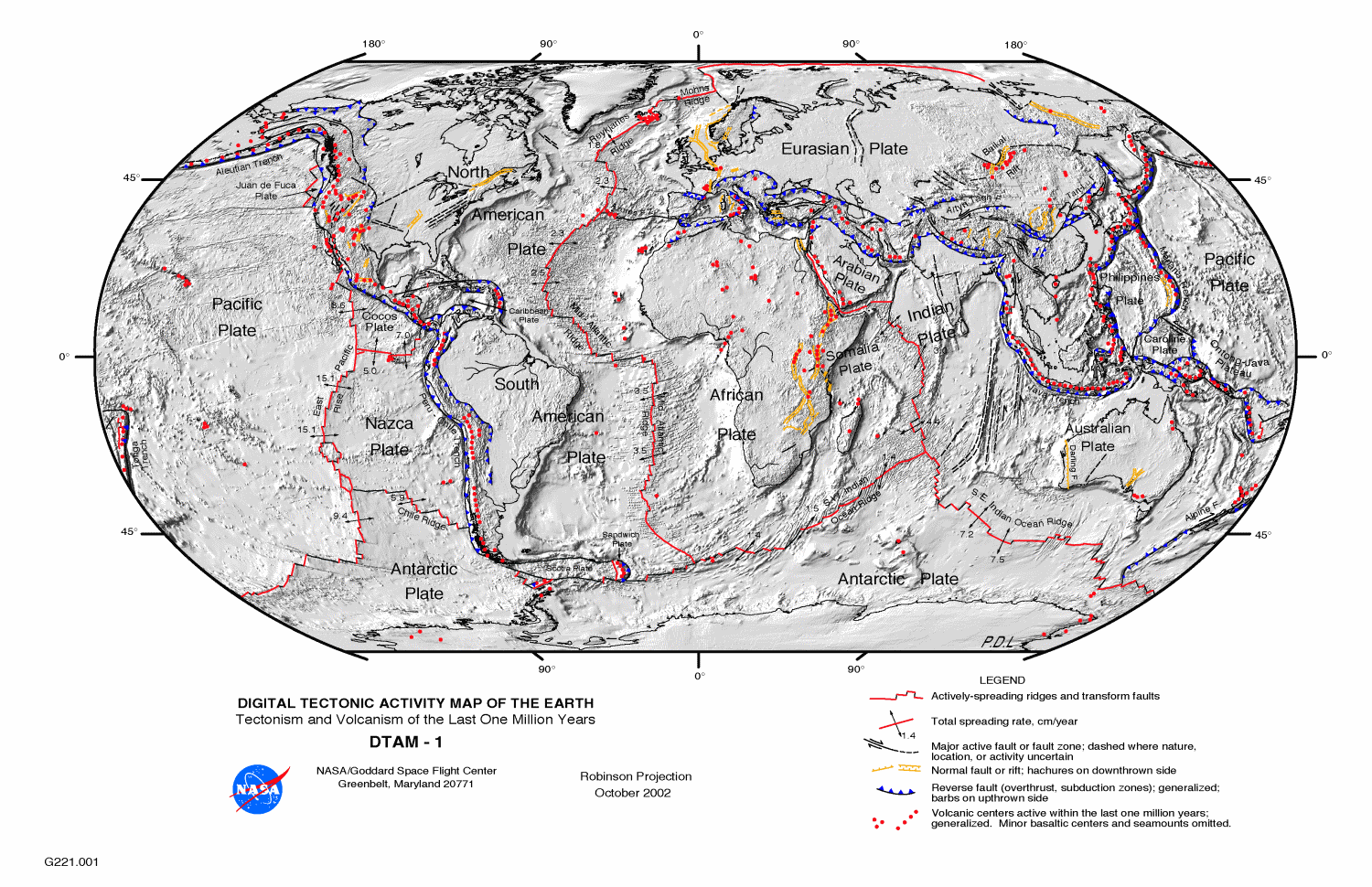
Through the year, we’ve talked about events that broke apart and combined the various tectonic plates on the earth, but today, as we’ve almost reached the present, I wanted to just summarize the way things are today. 


First, I know I talked repeatedly about oceanic crust and continental crust. They are quite different from each other, in density, thickness, and mechanical behavior, and those differences drive subduction and plate tectonics. But the two types of crust also move together, a lot. The North American Plate includes all of the North American continent – except the bit of California west of the San Andreas Fault – but it also includes the oceanic crust beneath the North Atlantic Ocean, all the way out to the Mid-Atlantic Ridge. Iceland straddles the mid-ocean ridge, a pile of volcanic material erupted because of a hotspot at depth, but the west half of Iceland is part of the North American Plate, and the east half is on the Eurasian Plate.  

Depending on exactly how you want to define “major,” there are 9 to 16 major plates. Africa has two sub-plates – Arabia, which is tectonically separated from Africa, but only by the width of the young Red Sea, and the Somalia Plate, breaking away along the East African Rift. The Somalia Plate is certainly separating from Africa, but in many ways and in many places, they’re still attached to each other too.

Then there’s the North American and South American Plates, both of which include the continent and the western half of the Atlantic Ocean. There is only a vague boundary between the North and South American Plates, because they are to a large extent moving together at a similar speed and direction. There is an extensional rift between North America and Greenland – but it failed, and Greenland is now completely attached to North America, and is moving with it.

Australia and India have their own plates and include more oceanic crust than continental, but like the Americas, they are almost locked together now that India has collided with Eurasia and slowed down. Antarctica also has its own plate, and except in some small sections, Antarctica is entirely surrounded by oceanic rifts. Everything else is pulling away. How can that be possible? You can’t pull away everywhere. Well, you can, for a while – the excess is taken up by collisions elsewhere on the globe, but eventually, even if the active rift between West and East Antarctica opens up, part of the Antarctica Plate will start colliding somewhere.

The Pacific Plate is entirely oceanic – no continental material except the bit of California west of the San Andreas Fault, which is traveling with the Pacific Plate. And the Pacific Ocean is really underlain by two large plates – the larger Pacific, and east of the East Pacific Rise spreading center, the Nazca Plate which is subducting beneath South America to lift up the Andes. The eastern half of the oceanic plate in the North Pacific was called the Farallon Plate, but it has been almost entirely subducted beneath North America. That subduction made for the various mountain-building events that created the Rockies, the Sierra Nevada, and the Coast Ranges.

The other big plate is Eurasia – Europe, and Asia except for Arabia and India and the far eastern tip of Siberia, plus the east half of the North Atlantic Ocean.

The smaller plates make for some interesting geography and tectonic activity. Arabia, breaking away from Africa, makes the Red Sea, and colliding with Asia makes the mountains of Turkey, Iraq, and Iran, and the Caucasus. The Philippine Plate is a small oceanic plate in the western Pacific Ocean. The volcanoes of the Philippines, Taiwan, and southern Japan are the result of the Philippine Plate subducting beneath the complex eastern margin of Asia, and the Mariana Trench – the deepest point on the ocean floor – is on the opposite side of the Philippine Plate, where the Pacific Plate is subducting beneath it. When two oceanic plates collide as they are doing here, all bets are off. One may subduct beneath the other, or the other way around, and the directions of subduction can even flip.

Between North America and South America, the Caribbean Plate is mostly oceanic, but there are some continental blocks on it too, in Nicaragua. This small plate is overriding the oceanic part of the Americas Plate, resulting in the volcanoes of the West Indies. There’s a similar narrow plate between the southern part the South Atlantic Ocean and Antarctica, called the Scotia Plate.

There are a bunch of little plates along the west coast of North America that are essentially the remnants of the old Farallon Plate – the remnants that haven’t yet been subducted. There’s the Cocos Plate, off southern Mexico, the Rivera Plate a bit further north, and the Gorda and Juan de Fuca Plates offshore from Oregon, Washington, and British Columbia. Where these plates in the northwest continue their ongoing subduction beneath North America, the subduction is producing a volcanic chain – the Cascade Mountains.

Beyond that, it starts to become a question of semantics – what’s a plate? In a way, every single zone bounded by active faults is an active plate – the fault separates two regions that are moving in different ways. But plates are really much grander objects, and they are separated from each other by really major breaks – not just a fault, but a change in the way the rocks behave and move. Even the small plates I described are considered to be plates because they are pretty clearly the left-over pieces of a once much larger plate.

Today, every possible kind of interaction between plates is ongoing simultaneously. The Pacific Plate slides past North America on the San Andreas Fault, but the Pacific Plate also is subducting beneath North America in Alaska and Mexico. North America and Eurasia are pulling apart along the Mid-Atlantic Ridge and along the Nansen Ridge in the Arctic Ocean, but the two plates are locked together in far eastern Siberia.

There are failed rifts all over the place, some of which were never much more than sags in the crust, such as the oil-rich Sirte Basin in Libya, and some of which became true oceanic spreading centers only to stop fairly quickly. That happened in what is now the South China Sea. Some subduction zones continue for tens of millions of years, and some abort after just a few million. The earth is an incredibly dynamic system – and what happens in one part of the globe will be accommodated, one way or another, even if the result is thousands of miles away. The dynamic earth isn’t just a recycling system for rocks, but it generates things that humans rely on daily, from oil to copper to salt. Plate tectonics is the basic underlying engine that drives the diversification of life, as well as its extinction.

—Richard I. Gibson

Maps from USGS or NASA, public domain

Monday, September 8, 2014

September 8. Pangaea begins to break up


The other day, I said that in the Triassic, Pangaea was pretty much still intact as a single huge continent, with the big embayment on the east side, the Tethys Ocean. But I’ve also said there were hints of the great breakup that was about to begin.  

As the Cimmerian blocks began to rift away from the northeastern coast of Pangaea, the southern portion of the supercontinent, the old Gondwana, was probably rotating a bit, so that where Africa and Europe were attached, they began to pull apart at least to some extent, but it’s not really completely clear exactly what was going on there during the Triassic. Further north and west, through the complex mountain ranges that formed during the Caledonian, Alleghenian, and Appalachian Orogenies, over many millions of years, the compression due to collision was giving way to extension.


Triassic Globe by Ron Blakey, NAU Geology, under Creative Commons license (notes by Gibson)


Even as early as the late Permian, a rift, a pull-apart, had begun to form between what is now northeastern Greenland and northwestern Norway. That narrow strait might have allowed sea water to invade the basins of northern Germany and the Netherlands, where the Permian Zechstein salt formed. By the middle of the Triassic, the rifting seems to have extended a long way into the combined North America-European continent.

Tethys reconstruction globe from Stampfli & Borel 2002
How do we know this? There are extensive deposits of terrestrial sediments scattered through the region – mostly offshore today – from southern Greenland to west of Ireland and France and Iberia, and on the North America side, from east of Newfoundland around the margin to south of Nova Scotia – which was still attached to Africa, about where Morocco is today. This was not a complete seaway, but the rifting was making basins, similar perhaps to the basins that received the Old Red Sandstone back in the Devonian, after the first big mountains formed through this zone, the Caledonian Mountains. It was a complex array of zig-zagging rift basins, and I really think it’s fair to think of it like the East African Rift today – long, linear interconnected rift zones, in places with lakes, in places just lowlands receiving eroded debris off the adjacent highlands.

Let’s take a break for a minute and talk about rifts. When I say “rift,” I mean a major break in a continent, where two parts of the continent pull apart from each other. Ultimately, such a rift might become an ocean basin, with the two continental fragments bordering it on each side. This process is often driven by the generation of new oceanic crust at a mid-ocean ridge. Heat rising in convection currents from the deep mantle brings molten material to the surface – or at least near the surface – in a linear zone. As more and more such material rises, the previous material has to move out of the way – and the crust of the ocean spreads apart, away from the mid-ocean ridge. If that ridge started beneath a continent, the inexorable force of rising heat and magma will eventually break even thick continental crust. That’s what’s happening today in East Africa, and it’s what was beginning to happen during the Triassic where North America and Europe were attached. This is the birth of the modern Atlantic Ocean.

Rifting. (I have tried and failed to
determine the owner of this image;
if you are the copyright owner, please let me know.)
But during the early and middle Triassic, we didn’t have much in the way of open oceans yet. Probably just that narrow strait next to Greenland in the north, and possibly some ocean between North Africa and southern Europe. The rest was a diverse lowland, a sag, with linear mountains surrounding lake basins and continental river systems. Think of it like a big mass of cold caramel – soft enough to stretch some, but brittle enough to break eventually. As you pull the caramel apart, the middle will sag, and finally will break with a pretty sharp edge, assuming the consistency is just right. Since most of the rocks are under the Atlantic Ocean today, they are known only from remote sensing studies, including seismic data, and from wells drilled for oil and gas exploration. Not quite the same as having them exposed for geologists to take rock hammers to.

I think two big questions might be occurring to you at this point. First, what makes a rift start? And second, in this case, why did the rift run more or less along the zone where the original collision had created a huge mountain uplift that went from northern Greenland all the way to West Texas and probably beyond?

Oceanic rifts start where the linear edges of mantle convection currents rise toward the surface. The ultimate controls on the geometry, size, and position of convection currents are poorly understood – it’s the distribution of heat down in the mantle, and the complex response of the solid earth to that. And the solid earth is not uniform, so variety will be the name of the game. It’s also possible that some rifts begin because isolated mantle plumes, or hot spots like those at Yellowstone and Iceland, rise and weaken the crust, essentially encouraging the rift to radiate from that location. To break continental crust, much thicker and stronger than oceanic crust, probably depends on some special circumstances, such as a pre-existing state of stress, but it seems possible that a mantle plume might initiate such a continental break-up. This is still a controversial topic. Here's a 2014 paper on this idea, and see also this paper from 2014 for an opposing view.

As for the second question, why did the Atlantic Rift begin to form pretty much right along the zone where the continents had come together, one simple rationale is that such a zone, full of faults and inhomogeneities, would be the weak point in the system. The central cores of the continents – the cratons, which we outlined in January, and the word craton means “strong” – would have been much more resistant to breaking apart than the collision belt. You might argue that the collision zone made the crust even thicker, and with lots of igneous rocks and metamorphism, the suture zone, where the continents were welded together, ought to be the strongest part. Maybe it was. But it’s an observational fact that the break-up of Pangaea – at least between Europe and North America – followed the old collision, more or less. There are some interesting exceptions that we’ll talk about as the break-up proceeds over the next month or so.


* * *

Today’s birthday is Raphael Pumpelly, born September 8, 1837, in Oswego, New York. His geological work was wide-ranging, from Chinese coal fields to the copper country of Michigan, but he focused on economic geology of mineral deposits. He was the first to explore the Gobi Desert scientifically and he was also in charge of the Northern Transcontinental Survey of Dakota, Montana, and Washington Territories in the early 1880s. Pumpellyite, a low-grade metamorphic calcium-iron silicate mineral, was named for him.
—Richard I. Gibson

Tethys reconstruction globe from Stampfli & Borel 2002:    http://www-sst.unil.ch/research/plate_tecto/alp_tet_main.htm#Introduction 

Globe by Ron Blakey, NAU Geology, under Creative Commons license (notes by Gibson)


References: P.A. Ziegler, Evolution of the Arctic-North Atlantic and the Western Tethys, AAPG Memoir 43, 1988.

Mantle plumes cause rifts? 

Wednesday, August 6, 2014

August 6. Pangaea


By the start of the Permian Period, about 299 million years ago, much of the supercontinent of Pangaea was assembled. Gondwana and Laurasia (North America plus Europe) were attached along the long complex Ouachita- Allegheney-Variscan Orogenic Belt, but as I described yesterday, there was a huge bay called the Tethys Ocean between the eastern part of Gondwana and much of Asia. Siberia plus Kazakhstan were still impinging on eastern Baltica, and there were plenty of isolated microcontinents floating around, things that would become parts of China, Central Asia, and Indochina.  


Globe map 300 million years ago by Ron Blakey, under CC-BY-SA & GFDL, from Wikimedia commons.


So Pangaea, which means “all earth,” wasn’t really quite all of the earth. But certainly most of it.

You should not think of the assembly of Pangaea as simply a convergence of everything. Before the end of the Permian, various slices were rifting off the supercontinent, although for most of the next 100 million years it did remain mostly intact. In fact much of it has remained more or less intact to this day – Eurasia and Africa do have some intervening breaks between them, but they’re still pretty close together.

Pangaea (Tethys at right center)
The ocean surrounding Pangaea is called Panthalassa, meaning “all ocean,” and the Tethys Sea was that huge branch between the eastern parts of Gondwana and Eurasia.

The idea of Pangaea goes all the way back to Alfred Wegener’s idea of continental drift published in 1915. Wegener suggested that if the continents had drifted apart, they must have started in some unified state. He used the name Pangaea once in a later edition of his book on the Origin of Continents and Oceans, and it was used by European and South African geologists thereafter. As Colleen Elliott and I discussed back in January, the concept of continental drift was largely rejected in the United States until the 1960s because there was no evident mechanism to make it happen.

During the course of this month we’ll talk about some of the various lines of evidence from the Permian that support the concept of Pangaea. With a few exceptions that we’ll discuss later this month, it’s fair to think of most of the Permian as a time when the supercontinent of Pangaea stayed intact.
—Richard I. Gibson

Globe map 300 million years ago by Ron Blakey, under CC-BY-SA & GFDL, from Wikimedia commons.

Pangaea outline map by Kieff, under Creative Commons license 

Saturday, July 26, 2014

July 26. The African Suture


Earlier this year, 2014, there was a flurry of news reports in the popular science press about the Brunswick Magnetic Anomaly in southern Georgia as the expression of the old boundary between Africa and North America when they came together in Pennsylvanian and Permian time.  

That’s fascinating, but it isn’t news. We’ve known this pretty much since the early 1980s or longer. There have been some new studies addressing the details of what’s going on there, but the fundamental nature of this linear zone has been known for years.

A magnetic anomaly is a departure from the broad general magnetic field of the earth. The magnetic anomalies that geologists like me care about represent geology, because they represent differences in magnetite content that can allow us to infer things about the subsurface. Most of my career, since 1975, has been focused on studying magnetic anomalies as well as anomalies in the earth’s gravity field, and trying to figure out what they mean. I made an interpretation of the magnetic map of the U.S. including the Brunswick anomaly as the suture zone between Gondwana and North America back in 1988.

Part of Magnetic Map of North America (USGS) showing Brunswick Anomaly (curving blue zone)
Across southern Georgia, and extending east into the Atlantic Ocean and west across Alabama, the Brunswick magnetic anomaly is a long, curving magnetic low, representing a strong contrast in magnetic material deep in the earth’s crust. There is plenty of discussion about its exact nature – is it a fault zone, a string of intrusive igneous rocks, simpler changes in rock type, or something else. But fundamentally, it represents the zone along which the leading edge of Gondwana collided with the southeastern margin of North America. We call this zone of amalgamation a suture zone, where continents or other blocks have been attached to each other, like a huge medical suture using a lot of different ways to do the attaching.

You usually see this part of the U.S. referred to as part of Africa, but the zone that includes all of Florida, some of the Florida Shelf, and the southern parts of Georgia and Alabama as well as possibly the Bahamas and points to the southeast were really part of Gondwana, occupying a triangular zone between what is now Senegal to Liberia on the African coast and Venezuela and the Guianas down to northeastern Brazil on the South American coast. This little bit of Gondwana had been part of the supercontinent for at least a few hundred million years, and it was at the forefront of part of the Allegheny-Appalachian collision in Pennsylvanian time that welded Gondwana to North America. They remained attached for close to 100 million years, forming part of the supercontinent of Pangaea.

White line is a highly generalized boundary of the terrane that was once part of Gondwana, but is now part of North America.
It wasn’t until the Jurassic Period, which we will get to next October, that Pangaea began to break apart again. As you might expect, it broke apart along its weakest zones, and some of the weak zones were the highly faulted and deformed areas where the continents had come together in Pennsylvanian-Permian time. Africa rifted away from North America approximately along the old suture between them – but not exactly. The rift split along different lines in what is now the southeastern United States, and Florida and southern Georgia and southern Alabama and the adjacent continental shelves got left behind. A bit of Gondwana had become part of North America.
—Richard I. Gibson

Links:
http://www.livescience.com/44633-brunswick-magnetic-anomaly-explained.html
http://www.geosociety.org/news/pr/2014/14-22.htm

1988 COCORP study
Brunswick anomaly

Sunday, March 16, 2014

March 16. Ordovician paleogeography


Plate tectonics, the process driven by heat convection down in the mantle, has operated pretty much continuously at least since the late Precambrian, and probably even longer than that. During the Ordovician, it seems that there may have been a little more “action” than at some other times – probably the normal variation in the intensity of tectonic activity.

Most of the supercontinent of Gondwana, which we first discussed on February 9, was finally assembled during the Ordovician, and it would remain together for the next 200 million years or more. At least by the late part of the Ordovician, Gondwana was situated near the south pole.


But apart from Gondwana, several important continental blocks, including Laurentia, which is the core of North America, Baltica, the heart of northern Europe, and Siberia, were still moving around pretty much independently. And moving continents means subduction zones, volcanic island arcs, and small continental blocks fragmenting and colliding. Those three major continental blocks, Laurentia, Baltica, and Siberia, were relatively close to each other, but there were also some complex island chains not too far away. One of the most important of those is called Avalonia, named for the Avalon Peninsula of Newfoundland.

The long, linear Avalon terrane today is found in Massachusetts, Maritime Canada, Newfoundland, southern Ireland and Britain, and maybe some bits of northwestern Europe. But during the Ordovician, it was separate from the major continental blocks. I think of Avalonia as something like the western Pacific today – from the Kamchatka Peninsula to Japan to the Philippines. A discontinuous string of continental fragments, volcanic islands, oceanic crust, and more – a real mess.  This string began to collide with North America during the Ordovician Period, probably causing the buckling of the crust that formed the Cincinnati Arch and Michigan Basin, which we talked about earlier this month. We’ll talk about the culmination of this collision, called the Taconic Orogeny, at the end of March.

You can imagine that such a complex strip of diverse geological settings wasn’t necessarily just sitting there idly, even before it collided. We’ll talk about some of the consequences of the plate tectonic events related to Avalonia in a few days.
—Richard I. Gibson


Ordovician 450 million years ago, map by Ron Blakey, via Wikipedia, public domain.

See also http://jan.ucc.nau.edu/~rcb7/global_history.html

Saturday, February 15, 2014

February 15. Plate Tectonics 1

Nerds in a Bar, volume 3. Colleen Elliott and Dick Gibson discuss the evolution of thought on continental drift. This episode isn’t specific to the Cambrian, but it will help provide general background for future presentations.


Image from USGS (public domain).