Geology

Geology
The 366 daily episodes in 2014 were chronological snapshots of earth history, beginning with the Precambrian in January and on to the Cenozoic in December. You can find them all in the index in the right sidebar. In 2015, the daily episodes for each month were assembled into monthly packages (link in index at right), and a few new episodes were posted from 2015-18. You may be interested in a continuation of this blog on Substack at this location. Thanks for your interest!

Wednesday, December 31, 2014

December 31. The 6th Extinction


So we’ve made it to the end of our geological year, covering 4.6 billion years of geologic time. 366 episodes, close to 180,000 words and a total of about 25 or 30 hours of programs. I hope you’ve enjoyed it! The podcast will not end, but the structure will change as we go into next year. It won’t be daily any more, sorry to say – there were times when it was really touch and go in terms of me getting the episodes out, but I’m happy to say I managed. Thanks for your interest – that was my main motivation once things got going. 

I’m not certain exactly what sorts of topics next year will bring. I’m not going to try to cover “current events” in any particular way because there are many good blogs and podcasts that do that. I expect I may do a few more that use my own work as a basis, and some posts will probably be based on topics in my other book, What Things Are Made Of. I want to try to do a few interviews with geoscientists working on interesting topics, and that may give it a Montana-centric flavor, but we’ll try to make things pertinent to a wide audience. Since I only covered 366 topics – and they were selected largely based on my own prejudices – there’s certainly plenty more that we can look at. Feel free to submit questions or suggestions, either through the blog or email me at rigibson at earthlink.net. You’ll get a spamblocker message, but I’ll find your email. I’m not going to make any promises, but I am going to shoot for at least one episode every week or ten days next year. 

I also will be assembling the existing podcasts into single recordings. I’m not sure how it will work in terms of file sizes, but I’m hoping that I can make each month of the previous series into one or two packages – without the repetition of the intro music and exit tagline. I’ll try to edit the episodes into those assemblies early in the coming year and make them available in the usual way, through the blog. 

To close the year, I thought I might address what has been called the Sixth Extinction. Of all the mass extinctions in earth history, only five have been really, really devastating. Those are the ones at the end of the Ordovician, in the Late Devonian, the biggest of all at the end of the Permian, the Triassic-Jurassic extinction, and the one that ended the Cretaceous Period and the Mesozoic Era. The case has been made that we are presently in the midst of another mass extinction, the Sixth great one.

There is an entire book, titled The Sixth Extinction: An Unnatural History, by Elizabeth Kolbert. It just came out in 2014, and I recommend it highly. The New York Times Book Review listed it as one of the ten best books of 2014. The book makes the case for a present-day massive die-off of organisms, ranging from bugs and bats to corals and rhinos. We’ve seen in the podcasts in this series that things like climate change certainly affect extinction rates, and there is no question that earth’s climate is changing at high rates right now. There’s also no question that human activities are affecting many of the things that contribute to climate change. It’s happening.

Kolbert integrates our knowledge of past extinctions, such as the disappearance of the ammonites, which you have heard about in this podcast series, as lessons for the present.

We don’t really know how many species of plants and animals exist on earth today, although we have good ball-park estimates. New species, even new large animals, are being found all the time. So it’s hard to say with certainty what kind of extinction rate is in progress, but some estimates say that as far as we can tell, extinction rates today are as much as 1,000 times those that typified most of earth’s history. We might argue about whether what’s happening now is on a scale comparable to the Big Five Extinctions, but at some scale, an extinction event is assuredly in progress.

The big, charismatic animals, like rhinos, elephants, tigers, and whales, that need extensive spaces for their lifestyles, are probably most threatened by human pollution and invasion of habitat, but who knows what’s going on in the insect world or the frog world? Those who study frogs are concerned. Is it possible to help all, or even most, species survive in a human-dominated world? I certainly don’t know. Should we even try? From both the altruistic and selfish points of view, it would probably be advantageous to try. Even human-centric people can’t deny the continual discoveries of beneficial products that come from obscure plants and animals.

For me as a geologist, I sometimes take the long view – the earth does not care. If humans kill off lots of things, including perhaps themselves, earth, and life, will continue. It always has, and until the sun burns out or some incredible catastrophe happens, it always will.

Thanks for joining me on this journey. If you’ve learned a tenth of what I have learned in putting these talks together, you’ve learned a lot! I hope it was fun!

—Richard I. Gibson

LINKS:
Extinction rates

Animals that went extinct in 2014

Tuesday, December 30, 2014

December 30. Modern Plate Tectonics


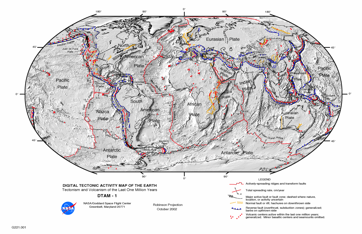
Through the year, we’ve talked about events that broke apart and combined the various tectonic plates on the earth, but today, as we’ve almost reached the present, I wanted to just summarize the way things are today. 


First, I know I talked repeatedly about oceanic crust and continental crust. They are quite different from each other, in density, thickness, and mechanical behavior, and those differences drive subduction and plate tectonics. But the two types of crust also move together, a lot. The North American Plate includes all of the North American continent – except the bit of California west of the San Andreas Fault – but it also includes the oceanic crust beneath the North Atlantic Ocean, all the way out to the Mid-Atlantic Ridge. Iceland straddles the mid-ocean ridge, a pile of volcanic material erupted because of a hotspot at depth, but the west half of Iceland is part of the North American Plate, and the east half is on the Eurasian Plate.  

Depending on exactly how you want to define “major,” there are 9 to 16 major plates. Africa has two sub-plates – Arabia, which is tectonically separated from Africa, but only by the width of the young Red Sea, and the Somalia Plate, breaking away along the East African Rift. The Somalia Plate is certainly separating from Africa, but in many ways and in many places, they’re still attached to each other too.

Then there’s the North American and South American Plates, both of which include the continent and the western half of the Atlantic Ocean. There is only a vague boundary between the North and South American Plates, because they are to a large extent moving together at a similar speed and direction. There is an extensional rift between North America and Greenland – but it failed, and Greenland is now completely attached to North America, and is moving with it.

Australia and India have their own plates and include more oceanic crust than continental, but like the Americas, they are almost locked together now that India has collided with Eurasia and slowed down. Antarctica also has its own plate, and except in some small sections, Antarctica is entirely surrounded by oceanic rifts. Everything else is pulling away. How can that be possible? You can’t pull away everywhere. Well, you can, for a while – the excess is taken up by collisions elsewhere on the globe, but eventually, even if the active rift between West and East Antarctica opens up, part of the Antarctica Plate will start colliding somewhere.

The Pacific Plate is entirely oceanic – no continental material except the bit of California west of the San Andreas Fault, which is traveling with the Pacific Plate. And the Pacific Ocean is really underlain by two large plates – the larger Pacific, and east of the East Pacific Rise spreading center, the Nazca Plate which is subducting beneath South America to lift up the Andes. The eastern half of the oceanic plate in the North Pacific was called the Farallon Plate, but it has been almost entirely subducted beneath North America. That subduction made for the various mountain-building events that created the Rockies, the Sierra Nevada, and the Coast Ranges.

The other big plate is Eurasia – Europe, and Asia except for Arabia and India and the far eastern tip of Siberia, plus the east half of the North Atlantic Ocean.

The smaller plates make for some interesting geography and tectonic activity. Arabia, breaking away from Africa, makes the Red Sea, and colliding with Asia makes the mountains of Turkey, Iraq, and Iran, and the Caucasus. The Philippine Plate is a small oceanic plate in the western Pacific Ocean. The volcanoes of the Philippines, Taiwan, and southern Japan are the result of the Philippine Plate subducting beneath the complex eastern margin of Asia, and the Mariana Trench – the deepest point on the ocean floor – is on the opposite side of the Philippine Plate, where the Pacific Plate is subducting beneath it. When two oceanic plates collide as they are doing here, all bets are off. One may subduct beneath the other, or the other way around, and the directions of subduction can even flip.

Between North America and South America, the Caribbean Plate is mostly oceanic, but there are some continental blocks on it too, in Nicaragua. This small plate is overriding the oceanic part of the Americas Plate, resulting in the volcanoes of the West Indies. There’s a similar narrow plate between the southern part the South Atlantic Ocean and Antarctica, called the Scotia Plate.

There are a bunch of little plates along the west coast of North America that are essentially the remnants of the old Farallon Plate – the remnants that haven’t yet been subducted. There’s the Cocos Plate, off southern Mexico, the Rivera Plate a bit further north, and the Gorda and Juan de Fuca Plates offshore from Oregon, Washington, and British Columbia. Where these plates in the northwest continue their ongoing subduction beneath North America, the subduction is producing a volcanic chain – the Cascade Mountains.

Beyond that, it starts to become a question of semantics – what’s a plate? In a way, every single zone bounded by active faults is an active plate – the fault separates two regions that are moving in different ways. But plates are really much grander objects, and they are separated from each other by really major breaks – not just a fault, but a change in the way the rocks behave and move. Even the small plates I described are considered to be plates because they are pretty clearly the left-over pieces of a once much larger plate.

Today, every possible kind of interaction between plates is ongoing simultaneously. The Pacific Plate slides past North America on the San Andreas Fault, but the Pacific Plate also is subducting beneath North America in Alaska and Mexico. North America and Eurasia are pulling apart along the Mid-Atlantic Ridge and along the Nansen Ridge in the Arctic Ocean, but the two plates are locked together in far eastern Siberia.

There are failed rifts all over the place, some of which were never much more than sags in the crust, such as the oil-rich Sirte Basin in Libya, and some of which became true oceanic spreading centers only to stop fairly quickly. That happened in what is now the South China Sea. Some subduction zones continue for tens of millions of years, and some abort after just a few million. The earth is an incredibly dynamic system – and what happens in one part of the globe will be accommodated, one way or another, even if the result is thousands of miles away. The dynamic earth isn’t just a recycling system for rocks, but it generates things that humans rely on daily, from oil to copper to salt. Plate tectonics is the basic underlying engine that drives the diversification of life, as well as its extinction.

—Richard I. Gibson

Maps from USGS or NASA, public domain

Monday, December 29, 2014

December 29. The Ends of the Ice Age


I know that I’ve implied that the change from the Pleistocene glacial period to the warmer Holocene was quite abrupt, about 10 to 12 thousand years ago. And it was, generally speaking, but it wasn’t a particularly smooth change.

Dryas octopetala, photo by Jörg Hempel,
used under Creative Commons license
.
Toward the end of the glacial time, as the continental ice sheets were melting back quite rapidly, various things happened to tweak the climate from one that was warming to one that was cooling again. Three of these cooling episodes are called the Dryas – Younger Dryas, Older Dryas, and Oldest Dryas. The Dryas is an Alpine and tundra-loving shrub of the rose family, the national flower of Iceland, which typifies these cool periods.

The peak of glaciation, with glaciers as far south as the Ohio and Missouri Rivers in North America and covering the British Isles in Europe, was about 21,000 or 22,000 years ago. The warming and melting that began by about 20,000 years ago was interrupted by the Oldest Dryas interval, which lasted from about 18,000 to 14,700 years ago. It appears to mirror the overall trends of the ice ages – a gradual fall in temperatures to a low point, followed by a relatively abrupt warm up over a short time span. The temperature estimates for all these events are based largely on measurements of oxygen, nitrogen, and argon ratios, which are proportional to temperature, from gases trapped in ice in Greenland and Antarctica, but they are supported by other lines of evidence too.

During each of the Dryas periods, much of Europe was tundra or taiga – Arctic conditions, but that does not mean lifeless. The taiga or boreal forest is one of the largest biomes on earth today, supporting vast forests and wide diversity of large animals, from caribou and yaks to bears and many birds. The treeless tundra is less biodiverse, but still not really barren.

After a fairly short warming period, fewer than 1,000 years, the Older Dryas cooling took place for a short time, from about 14,100 to 13,900 years ago, only a couple centuries. Its expression is largely European, so the changes may not have been global in scope.

The Younger Dryas is the best-known of these cool periods. It lasted from about 12,800 until about 11,570 years ago. It seems to have ended in a step-wise manner, in increments of 5 or 10 years over as short a period as 50 or so years. The end of the Younger Dryas is dated by various means quite accurately, to between 11,545 and 11,640 years ago, with 11,570 a common estimate.

The Younger Dryas, like the earlier events, was felt most strongly in Europe, though there is evidence for it in the Pacific Northwest of the United States. Scandinavia and Finland were under ice sheets – still, or again. Britain was largely tundra or taiga, as was most of what is now the North Sea, which was dry land supporting an extensive flora and fauna.

By now, you can probably guess at some of the speculated causes for the Younger Dryas. It’s been suggested that there was some impact at about 12,900 years ago that initiated the cool period, but I think that idea has been largely discredited. There was a decent-sized eruption of a volcano at Laacher See, near Koblenz in Germany, also at about 12,900 years ago. It was comparable to the eruption of Mt. Pinatubo in 1991, and while it may have had some effects, it’s pretty hard to see it as THE single cause of a 1,300-year cooling event.

I think the most likely cause is some change in the fundamental heat engines of the Northern Hemisphere. The focus of this line of reasoning is the circulation of warm waters to the north in the Atlantic Ocean – specifically, the Gulf Stream and the more important deep-water exchange that keeps the North Atlantic warmer. This works because of the variable density of sea water at different temperatures, so it sets up a continuous cycle of circulation and exchange.

For the Younger Dryas, the idea is that this circulation was shut down because of an influx of fresh water to the North Atlantic. This isn’t really unreasonable. The huge continental ice sheets of North America were melting, and the water had to go somewhere, but it’s a little more challenging to explain the abruptness of the changes. But we have a likely smoking gun. I talked about some of the glacial meltwater lakes in North America the other day – but I left out one of the largest – Glacial Lake Agassiz. Named for the eminent glacial geologist Louis Agassiz, this lake fronted the retreating ice sheet in what are now Manitoba, Saskatchewan, North Dakota, and Minnesota, with a possible connection to a similar glacier-margin lake that covered much of northern Ontario. The surface area was much larger than today’s Great Lakes.

Lake Agassiz map by Warren Upham, USGS Monograph 25, 1895 (public domain). The extent of the lake was actually larger than shown here.

While the continental ice sheet was still present to the north and east, Lake Agassiz drained to the south, through valleys now occupied by the Minnesota and upper Mississippi Rivers. When the ice melted enough, there could have been an emptying – either catastrophic or not, into Hudson Bay and thence into the North Atlantic. This is the influx of fresh water that is the most likely culprit in the shutdown of the North Atlantic circulation, and the cause of the Younger Dryas.

There’s one more cool period to mention – the Little Ice Age. It wasn’t really an ice age, but it was a distinctly cooler time, approximately 500 years, from 1350 A.D. until about 1850 A.D. There were several pulses of cold during this interval, well documented historically, including between about 1460 and 1550, from 1650 to 1715, and from 1770 until 1820 – and now I’m not using years ago, but the actual dates, A.D.

The likely causes are the usual suspects. One interesting one is changes in the sun’s output. Two of the coldest times coincide with periods when the sun had virtually no sunspot activity. The best known of those is the Maunder Minimum, from 1645 to 1715. Volcanic activity is of course another possibility. The eruption of Tambora, in Indonesia in 1815 famously caused the “Year Without a Summer” in 1816, and there were other major eruptions in the early 1800s, which could have impacted that cold period.

But it’s also possible that that slowdown of the North Atlantic circulation was a factor, if not THE factor. The Little Ice Age follows the Medieval Warm Period, which lasted from 950 to 1250 A.D. It was a time when the Vikings colonized Iceland and Greenland and northern Newfoundland; the latter two colonies were abandoned after the Little Ice Age began. The warm period could have caused more melting, but a more likely possibility is that it affected atmospheric circulation patterns, resulting in a persistent jet stream that might have kept Europe, especially, cooler, and might have had even global implications. For much more on this idea, and the Little Ice Age in general, I strongly recommend a book, The Little Ice Age: How Climate Made History, 1300-1850, by Brian Fagan (Basic Books, 2001)  

And for a good look at how we understand recent climate changes, I recommend The Two-Mile Time Machine: Ice Cores, Abrupt Climate Change, and Our Future, by Richard Alley (Princeton University Press, 2002). 


* * *

Before I close today I want to thank my friends, colleagues, and listeners for their suggestions, but in particular I thank geologists Patricia Dickerson in Texas, Stephen Henderson in Georgia, and Colleen Elliott right here in Butte, Montana, for their support and suggestions for topics in this series. Thanks!

—Richard I. Gibson

Younger Dryas causes 

More Younger Dryas causes 

Dryas octopetala, photo by Jörg Hempel, used under Creative Commons license.

Lake Agassiz map by Warren Upham, USGS Monograph 25, 1895 (public domain). The extent of the lake was actually larger than shown here.

Sunday, December 28, 2014

December 28. Supervolcanoes


The Pleistocene is justly famous for the glaciations, which certainly dominated things. But the world doesn’t stop for glaciers, and plenty of other things were going on. Like supervolcanoes.

A supervolcano is a big one, conventionally taken to be a single eruption of more than 1,000 cubic kilometers, or 240 cubic miles. That’s a volume vastly greater than even many significant, damaging eruptions – for comparison, Mt. St. Helens in 1980 ejected about 1.2 cubic kilometers (or less) of material. So a supervolcano would be at least 833 times that volume. 

In this comparison of "dense rock equivalent," Toba erupted more than 11,000 times the volume of Mt. St. Helens in 1980.


We’ve talked about a lot of volcanic events in this series, but most of them were likely to be many events over long periods of time, a million years or more, adding up to a lot. One exception might be the eruptions that created what is now the Ordovician Deicke Bentonite that we talked about March 24. That might have been a single eruption, and if it was, it might have been the largest in at least the past 600 million years. Its ejecta volume is estimated at 5,000 cubic kilometers or more. 

So these things were probably happening sporadically throughout earth’s history. The favored locations would be subduction zones or hotspots, places where heat can build up and pressures can increase to the point where the crust can’t contain them, and they erupt violently. 

During the Quaternary, we know of six eruptions with volumes of 1,000 cubic kilometers or more. The largest, at what is now Lake Toba in Sumatra, had a volume of 2,800 cu km and happened about 74,000 years ago. That eruption is linked to a controversial idea that the ensuing global winter lasted perhaps 10 years, and, based on genetic studies, might have reduced the existing human population of the planet to as few as 3,000 to 10,000 individuals. It is controversial, and 75,000 years ago the evidence of human life is spotty at best. Consider this to be another idea for which the jury is still out. 

The second largest supervolcano eruption was at Yellowstone. In fact two of the six Quaternary supervolcano eruptions were there, one at 2.1 million years ago, and the other at 640,000 years ago, with volumes of about 2,500 and 1,000 cu km respectively. There was another large eruption there about 1.3 million years ago, only about a tenth the size of the one at 2.1 million years ago.

The fourth Quaternary supervolcano was in Argentina, about 2.5 million years ago just as the Quaternary was starting, and the other two were in New Zealand, in the Taupo Volcanic Zone on the North Island. Those two eruptions were at about 254,000 and 27,000 years ago – the latter is the most recent supervolcano eruption that has occurred. Its volume, about 1,200 cu km, is still 1,000 times that of Mt. St. Helens in 1980.

Some supervolcanoes seem to work in ways that are different from regular volcanoes. To release the vast volumes, special conditions are required. Let’s use Yellowstone as an example – and in passing, make the argument for why such an eruption cannot be imminent there.

The mouths of supervolcanoes are much larger than the craters that form at the top of a standard volcano. A caldera is a collapsed region that has fallen into a magma chamber beneath it – a magma chamber that had to evacuate its magma in many small eruptions to allow for the collapse. When the crust over the chamber collapses, all the fractures cause a rapid release of pressure, and the confined, pressurized magma that’s still down there can come out, violently. It’s like a pressure cooker – the relief valve on the top is like the geysers at Yellowstone, releasing pressure and keeping things safe. Without that, the pressure could increase and ultimately blow the cooker apart.

Or think of an apple pie. You poke holes in the crust to allow steam, the pressure inside, to escape. If you didn’t, cracks might develop and some of the filling could escape, but the crust would still be there. But if enough of the filling escapes, say around the edges of the pie, the crust on top might collapse, cracking, and the instant reduction of pressure would allow the entire contents of the pie to explode up to the ceiling.

So my point is, you can’t really have a caldera collapse, which would make a supervolcano eruption, without emptying enough of the magma chamber for the crust to collapse into it. The last time any magma was erupted at Yellowstone was 70,000 years ago – and not much came out. I think we need to have a LOT more little eruptions – magma, not just the hot water – before anything like a major collapse is likely that would produce a supervolcano eruption. I live 120 miles away and I’m definitely not losing any sleep over it. Besides, if it does happen, there’s precious little we can do about it. Yellowstone’s supervolcano eruptions have deposited ash as far away as the state of Mississippi, so the area of devastation would be huge, and in a big way dependent on the wind directions at the time.

With only three data points for the present Yellowstone caldera eruptions, it’s irrational to see any predictable regularity to them, at least not more than ball-park figures like plus or minus 200,000 years, and even that could be far, far off in such a chaotic system.

Supervolcano eruptions happen. Don’t worry about it. Regular eruptions are far more frequent and we can plan for them, though even much smaller events can be incredibly disruptive, as the unpronounceable Icelandic eruption a few years ago proved. Its erupted volume was less than 1 cubic kilometer.

* * *

December 28, 1835, was the birthday of Archibald Geikie, in Edinburgh, Scotland. He was an eminent scholar of Scottish geology, but he expanded his work on volcanics to include western North America as well. He is probably as well known for his popular writings about science as for his technical work. Also born this day, in 1894 at White Plains, New York, was Alfred Romer. His focus from his base at Harvard was in the field of vertebrate paleontology. He classified the labyrinthodonts, and the basics of his general classification of the vertebrates is still in use today, with modifications and expansions.

Also on this date, December 28, 1908, a strong earthquake hit Messina, Sicily, the location that the Messinian stage of the Miocene was named for. Messina and other major cities were practically destroyed, and at least 70,000 people were killed. There was a tsunami as well, and the final total death toll is put at about 123,000. The quake was a result of the ongoing Alpine collision between Africa and Europe. Africa is pushing northward and small blocks – Italy, Sardinia, and the oceanic crust in the Tyrrhenian Sea, are being forced over the leading edge of Africa. It’s a really complex zone, and Mt. Etna, the active volcano near Messina, is another consequence of this tectonic activity.
—Richard I. Gibson

Supervolcanoes 

Saturday, December 27, 2014

December 27. Glacial and Pluvial Lakes


Today’s glacial topic is lakes again – but this time, it’s lakes that are gone. Glaciers were constantly melting, and the runoff, from on top of them, beneath them, along them, and in front of them had to go somewhere. Often, it just ran in rivers away from the glaciers, and the sediment carried by that flow created extensive deposits called outwash, glacially-derived sediment plains and mounds and more.

But depending on the topography around a glacial front, you might get a lake pooling there, especially at times when glaciers were retreating. As I mentioned yesterday, the terminus of a stagnant glacier could result in a pile of sediment called a moraine, and combined with pre-existing topography, could easily form a lake. This happened repeatedly, and we recognize lakes by their typically thin-bedded sedimentary layers. In some cases, the layers represent annual sequences like tree rings – a winter layer of minimal sediment and a summer layer when more melting brought more sediment into the lake. 

Yosemite Valley, California, is one of the best examples of a glacially-carved valley anywhere. It has the characteristic U-shape, with steep walls ground away by glacial ice. Yosemite Valley contained more than 3,000 feet of ice at the peak of the most recent glaciation. As the transition to the present interglacial period happened, probably 11,000 to 9,000 years ago, the valley floor became the site of a lake about six miles long, with the terminal moraine at the valley mouth impounding it. The situation was much like that of the Finger Lakes in New York, except in high mountain country where the bedrock is the granitic rocks of the Sierra Nevada Batholith. So the floor of Yosemite Valley today is quite flat because of those lake sediments – it’s not really truly U-shaped.


You don’t have to have a moraine to dam a river. A tongue of ice can do it, too. That’s what happened repeatedly in northern Idaho about 13,000 to 15,000 years ago, where an ice dam 2,500 feet high impounded the ancestral Clark Fork River. The resulting Glacial Lake Missoula was 2,000 feet deep and more than 225 miles long, in many branches into the mountain valleys of Montana.   

From time to time, with the changes in the climate and the build-up of pressure behind the ice dam, the ice would melt and erode until the lake began to empty catastrophically. The water volume is estimated at 60 times the discharge of the Amazon River, draining the entire lake in days to weeks. All that water poured out over eastern Washington state, where it carved the landscape into what’s called the Channeled Scablands today. There are features all over this country reflecting these events, from giant ripple marks at Camas Prairie, Montana, to dry waterfalls in Washington and wave-cut shorelines in the hills around Missoula, Montana that represent multiple lake levels. There were many fillings and emptyings of Glacial Lake Missoula, probably at least 40 times. 

There’s lots more to this fascinating story, of course, and lots to see in the area where it happened. I think your best source for detailed information about it is a book by David Alt titled Glacial Lake Missoula and its Humongous Floods (Mountain Press, 2001).

Glacial and Pluvial Lakes (and route of Bonneville and Missoula Floods)
Map by Fallschirmjäger, used under Creative Commons license 
There are a couple more big lakes that developed in the west. We call these pluvial lakes, meaning rain-derived, because they were not the direct result of snow and ice melt. Much of western Utah was covered by Lake Bonneville. The Great Salt Lake is a remnant of this lake, but Lake Bonneville covered more than 10 times the area of the Great Salt Lake. The Wasatch Mountains at Salt Lake City show two prominent horizontal lines which are shorelines of Lake Bonneville. It was more than 1,000 feet deep, and like Glacial Lake Missoula, it had a catastrophic emptying. The Bonneville Flood was about 14,500 years ago when about a third of Lake Bonneville emptied through Red Rock Pass in Idaho, onto the Snake River Plain. The dam that broke to release this flood wasn’t ice, but was topographic highs composed of lava and sediment eroded from nearby mountains.

There were many smaller pluvial lakes across the west, but the second-largest, after Bonneville, was Lake Lahontan in western Nevada. Pyramid Lake is a remnant of that lake.

The glacial period had consequences even away from the huge continental ice sheets of North America and Europe. In Bolivia, the Salar de Uyuni is a huge salt flat, covering more than 4,000 square miles or 10,000 square kilometers. It was a lake during the Pleistocene which has since dried up completely, leaving the salts behind that precipitated from the evaporating water.

* * *

On December 27, 1939, an earthquake hit Erzincan in eastern Turkey. The death toll was about 33,000, complicated by cold weather and blizzards. The quake was on or near the North Anatolian Fault, a strike-slip fault similar to the San Andreas Fault in California. The ultimate push comes from the Arabian Plate sliding northwards and forcing the small Anatolian Plate to be squeezed to the west. The Anatolian Plate is one of the blocks that made up the Cimmeride Continent, and today it makes up most of Turkey. The North Anatolian Fault separates that block from a narrow strip along the southern coast of the Black Sea, which is moving to the east relative to the Anatolian Block. Since the Erzincan quake in 1939, there have been seven strong earthquakes on the North Anatolian Fault, occurring progressively to the west. It may be that each quake adds stress to the next segment to the west, essentially triggering the later quakes.

—Richard I. Gibson

Links:
Glacial Lake Missoula
Glacial Lake Missoula video 
Salar de Uyuni 
Map by Fallschirmjäger, used under Creative Commons license 

Friday, December 26, 2014

December 26. The Great Lakes


from NASA
The origin of the Great Lakes goes back hundreds of millions of years, to the Silurian and Ordovician Periods of the Paleozoic and even longer ago. You may recall the resistant Silurian rocks that surround the Michigan Basin – but today, the important rocks are the underlying strata, the less resistant beds.

Lake Superior is underlain by the Mid-Continent Rift System, established more than a billion years ago (we talked about it January 26 and 27). There’s another fundamental break, called the St. Lawrence Rift, that formed about 570 million years ago in very late Precambrian time. It underlies the St. Lawrence River valley in Canada, where it is still seismically active, and it may extend as a weak zone southwest to where Lakes Ontario and Erie are today. And finally, around the Lower Peninsula of Michigan, alternating layers of high and low resistance were laid down over Paleozoic time, and warped into the bowl-shaped Michigan Basin.  All these things gave glaciers some paths to follow that were easier than others. 


The Pleistocene continental ice sheets had several points of origin. In eastern Canada the Laurentide ice sheet was centered in northern Quebec, but the ice flowed thousands of miles to the south and west. When it reached the area of today’s Great Lakes, it went into the low-lying areas underlain by weaker rocks, digging those areas into basins where ice thickness was somewhat greater. The ice covered everything around Michigan, including the resistant Silurian rocks, but it eroded more in the weaker zones. There’s one little area in Wisconsin where two of the main lobes of the ice sheet came together but left a small zone ice-free, but completely surrounded by ice.  

from US Army Corps of Engineers
Glaciers came and went multiple times. When you hear about glaciers “retreating,” don’t think of it as backing up. With minor exceptions, glaciers don’t back up. Glacial retreat just means that the rate of melting at the ice front exceeds the rate at which the ice is advancing. In the Great Lakes area, advances and retreats eventually made the old basins noticeably lower than the surrounding highlands, and those lowlands were filled with glacial meltwater.

The modern lakes are fed by precipitation including snowmelt, as well as by the rivers in the region. They are the largest volume of surface fresh water on earth, accounting for about 21% of the total.

While we’re on the topic of lakes, the Finger Lakes of New York also owe their origin to the Pleistocene glaciation. It’s basically the same thing as the Great Lakes, but on a smaller scale. Pre-existing river valleys were widened and sculpted by valley glaciers, and natural dams were built that created the Finger Lakes. Those natural dams are called moraines, and they represent a place where a glacier was neither advancing nor retreating, but in a continuous state of melting in place. The ice carried with it all sorts of debris – rocks and soil – which was deposited into a mound called a moraine. When that pile was at the terminus of a long valley glacier, it ended up serving as a dam to create a lake in the valley where the glacier used to be.

* * *

Today’s anniversary is one that many of you probably recall – the earthquake and ensuing tsunami on December 26, 2004, which killed an estimated 230,000 people in 14 countries. The earthquake was on the subduction zone off the northern coast of Sumatra, in Indonesia, where the Indian-Australian Plate, which is oceanic in that area, is subducting beneath an extension of the Eurasian Plate into southeast Asia and Indonesia. Most of the western and southern islands of Indonesia are volcanic, the magmatic arc that forms above the subduction zone. It’s complicated somewhat by the larger islands, especially Sumatra, having elements of more rigid crust, possibly even some small continental blocks. The quake’s magnitude of about 9.2 is the third largest ever recorded. More than 1,600 km, 1,000 miles, of fault broke and moved an estimated 15 meters, or 50 feet. That’s incredibly huge, and that sub-sea movement is what generated the tsunami. The tsunami was the most devastating aspect of the quake, and it traveled more than 5,000 miles. It was still 5 feet high in South Africa. The greatest number of casualties was in Indonesia, with about 131,000 deaths, but the tsunami killed at least 35,000 in Sri Lanka, 12,000 in India, 5,000 in Thailand, and nearly 100 on the coast of Africa.
—Richard I. Gibson

Drawing Public domain (US Army Corps of Engineers) ; Satellite image from NASA

Thursday, December 25, 2014

December 25. Quaternary Megafauna Extinctions


Mammoths, mastodons, saber-toothed cats, American horses and camels, the giant bear, the Irish elk, Glyptodonts, which were giant relatives of the armadillo, the Megatherium, an elephant-sized ground sloth, giant kangaroos, a 7-foot-long beaver, and dozens of other large animals and animal groups, collectively called megafauna, died off during the Quaternary Period of the Cenozoic Era, many of them at about the time of glacial retreat, 10,000 to 12,000 years ago at the end of the Pleistocene Epoch. Some of them were relatively new to planet earth, and some species had been around for millions of years. 

Don’t visualize this extinction as an instant in time, or really even a short period of a few hundred years. It’s true that there seems to be a spike in extinctions right at the time the glacial period was ending, 10 or 12 thousand years ago, but many animals, including for example the giant terror birds of South America, were becoming extinct at about the beginning of the Pleistocene glaciation, 2.5 million years ago.   

Mammoth (left), American mastodon (right) Image by Dantheman9758, used under Creative Commons license

And how do we know something was completely extinct? We can only go by the fossil record, and fossils of modern large animals are rare. Even for a particular species, extinction can take thousands of years, winding down to the last mastodon, or passenger pigeon, or whatever. Mammoths got started about five million years ago, in the Pliocene, and were mostly gone at about the end of the glacial period, 12,000 years ago. But small populations survived on isolated Arctic islands such as St. Paul, off Alaska, and Wrangel, off Siberia, as recently as 3700 years ago. Different species in different niches disappeared sooner or later, depending on circumstances. The pygmy mammoth probably survived on the Channel Islands of California until about 11,000 years ago.

So, why did the mammoths, giant sloths, and all the rest die? The first obvious explanation is the dramatically changing climate. Glacial environments certainly constrain food supplies and habitat, and other habitats, even in temperate zones, change. That could account for some of the extinctions early in the Pleistocene, 2 to 2½ million years ago. But why would so many go extinct at the end of the glaciation? Well, change is change, and warmer might not necessarily always be better for all species; forests supplanted grasslands in the north, perhaps denying mammoths their main food sources. It might be a simple matter of inability to adapt to the changes. Once a population becomes small, many things – disease, a big storm, a flood – could have been the final blow that ended a species that may have been in decline for some time.

The second primary idea for the extinction of the Quaternary megafauna is still somewhat controversial, and involves hunting of the animals by predators – specifically, early humans. There’s no question that humans hunted and ate some of these animals – or hunted them to remove them as threats. Homo erectus was killing mammoths a million and a half years ago. The question really is, were humans the primary, or even a major, cause of the extinctions.

There’s pretty good correlation between the arrival and expansion of humans in various areas with the demise of the large mammals. The correlation in time and space alone does not mean the one caused the other. Arguments against this hunting hypothesis include the idea that the small populations of humans would not likely have been enough to eradicate millions of animals. And while the correlations are best in the Americas and Australia, the extinctions take place at about the same time in Eurasia, where these animals had been exposed to human threats for far longer.

The bottom line is that the ultimate cause of extinction of so many large mammals is uncertain. Humans may have had a role, either large or small, and climate factors are likely to have been important, and perhaps even controlling in the extinctions. When you take multiple climatic factors into account, including temperature changes, precipitation patterns, vegetation and habitat changes, maybe that’s enough to explain most of the extinctions, and humans or disease or something else were simply the exclamation point at the end. In such complex systems as the earth, it’s almost impossible to point to any single thing as THE cause, and as usual, the most likely answer is a combination of many factors. We really don’t know.
—Richard I. Gibson

Giant mammals
Mastodon extinction 
Extinctions affected survivors (e.g. coyote) 
Pleistocene beasts (an excellent blog)
Debunking the impact idea 

Image by Dantheman9758, used under Creative Commons license.   

Wednesday, December 24, 2014

December 24. Pleistocene Ice Ages


There have been at least five major glacial periods in earth’s history – two in the Precambrian, one at the end of the Ordovician, one during the Carboniferous, and now. “Now” is perhaps an overgenalization, but it’s not all that certain that the most recent ice age is over. It started about 2.6 million years ago, and occupied the Pleistocene Epoch of the Quaternary Period of the Cenozoic Era. It ended – if it has ended – about 12,000 years ago, which is taken to be the end of the Pleistocene and the start of the Holocene, the present-day epoch of geologic time. 

I say we don’t know if it’s over because the 2.6 million years saw at least four major and several minor pulses of glaciation that alternated with times called interglacials, when the ice was much less extensive. We may be in the early stages of an interglacial period, or the whole cycle may be over. 

Maximum glaciation (ice shown in black) by Hannes Grobe/AWI, used under Creative Commons license.   
At the peak, glacial ice reached as far south as the Missouri and Ohio Rivers and New York City in North America, and across the British Isles, central Germany, and most of the plains of western and central Russia. Continental ice sheets as much as 3 to 4 km thick (2 to 2½ miles) were prevalent in the northern hemisphere, which seems to have been affected more than the southern hemisphere, though the Antarctic Ice Sheet expanded. Mountain glaciers in southern South America, New Zealand, and in the northern hemisphere also grew significantly.

Because so much water was locked up in the ice, sea level fell about 120 meters, or 390 feet. Huge areas of what are now the continental shelves, under water, were dry land, including the Bering Sea off Alaska, which created the famous Bering Land Bridge between North America and Asia.

What caused it? Over the course of these podcasts, you’ve heard about ideas of global cooling related to volcanism that might have led to glacial periods, as well as ocean circulation, the rise of plants that changed greenhouse conditions, and other things as possible causes for the sporadic glacial times through earth history. The bottom line is, we really don’t know for certain. The modern glacial period, the past 2½ million years, may be just the culmination of cooling that dates to 34 million years ago, when the Antarctic Ice Sheet got going.

One factor that has been promoted as a cause for ice ages is the variations in earth’s orbit. Regular cycles in the tilt of the earth’s axis and in the shape of the obit around the sun produce regular variations in temperature – but that happens all the time, and there have only been a handful of glacial periods over billions of years, so there must be more to it.

Pleistocene ice extent (USGS)
Ocean currents and the arrangements of continents may have a role. I mentioned the opening of the Drake Passage, creating a truly circumpolar oceanic current around Antarctica, as a possible factor in the growth of ice there. In the modern Northern Hemisphere, the changing arrangements of continents has made the Arctic Ocean an almost landlocked sea, and combined with the growth of the Isthmus of Panama about 3 million years ago that drastically changed global circulation patterns, maybe that all created the tipping point that led to the onset of glaciation.

A decrease in carbon dioxide levels would reduce the greenhouse effect and global average temperatures would be cooler. Such changes can be observed in ice cores, and there was indeed a general, slow, but significant decrease in CO2 in the atmosphere through most of the Cenozoic until recently. That would still call for a threshold or tipping point because the onset of significant continental glaciation was pretty abrupt, about 2.6 million years ago, and it is hard to explain the changing CO2 levels in ways that would account for the rapid changes from glacial to interglacial periods. And even within predominantly glacial or non-glacial times, there was lots of variability. It’s best to think of it as “mostly glacial” periods that lasted on the order of 40,000 to 100,000 years, and shorter interglacial periods, maybe 20,000 to 30,000 years – but with oscillation and change throughout it all.

The last glacial maximum was about 22,000 years ago, and at that time there was more ice in North America than in present-day Antarctica. Most of the estimates of the alternating temperatures and ice volumes suggest a gradual build-up to an ice maximum, over a period of 40 to 60 thousand years, but a pretty abrupt drop into an interglacial, over a period of around 10,000 or 15,000 years. That’s pretty much how long it’s been today since there were glaciers in Ohio.

There are at least 9 professional journals devoted to the study of the Quaternary and the glacial period. I’m going to leave the question of the cause at what I’ve said in this episode, recognizing that there is plenty of research going on. The effects of the ice age are much easier to describe than the causes, and four of our next five episodes will relate to some of those.
—Richard I. Gibson

Impact on Gulf of Mexico
Maximum glaciation by Hannes Grobe/AWI, used under Creative Commons license.    

Tuesday, December 23, 2014

December 23. Primates


The end of the Paleocene and start of the Eocene was apparently a stimulating time, in terms of evolutionary diversity for the mammals. The oldest known primate-like animal dates to this time, from lake beds in France and from North America, about 56 million years ago. Plesiadapis was a small lemur-like animal adapted to climbing trees and eating plants, although it may have been an opportunistic omnivore. Its ancestors are uncertain, but it probably evolved in North America and migrated to Europe.

Mesopithecus (Gaudry, 1867)
By Oligocene time, the lineages of both the Old World and New World monkeys had been established. Many fossils have come from the East African rift valleys, also the source of many hominid fossils. The lake deposits there preserve these rare remains relatively well. 

The Miocene, around 12 to 18 million years ago, saw the divergence of groups such as the great apes, orangutans, and gibbons. By very late Miocene, 5 to 7 million years ago, many monkeys were probably quite recognizably modern in appearance. There’s an excellently preserved example called Mesopithecus, found in Greece, that lived about that time and likely lived on fruits and leaves. It was about 16 inches long.

The primitive primates of Madagascar, lemurs and their kin, present a challenge to plate tectonics. Madagascar was already separated from the other continental masses by Paleocene, when these animals developed. So how did they get there? In fact there are only five orders of land mammal on Madagascar today. The favored idea has usually been rafting – drifting of land animals on floating mats of water-borne debris, though that idea relies on a lot of luck. The luck depended on a relatively short window of geologic time, between 60 and 20 million years ago, when the distances and currents would make the rafting idea plausible. The best estimate for the colonization of Madagascar by primates is probably early to middle Eocene time, 40 to 52 million years ago. 

Alternatives to the rafting idea include the presence of an ancestral primate on Madagascar, but none have been found, and “island hopping,” crossing the distance in short spurts to intervening islands – but the likelihood of such islands is low. I don’t think there is unanimous agreement as to how primates got to Madagascar, but for now I think the rafting idea is most likely, even if it was actually pretty unlikely. Just more likely than the other possibilities. Once they got there, the lemurs and other primates probably survived because they lacked the competition from the more advanced monkeys that developed in Africa by Oligocene time.
—Richard I. Gibson

Lemur origins 

Reconstruction of Mesopithecus from A. Gaudry, Animaux Fossiles et Géologie de l’Attique. Recherches faites en 1855–1856, 1860 (1867), public domain.

Monday, December 22, 2014

December 22. Sierra Nevada and Wasatch Front


Today’s episode is a follow-up to the Basin and Range discussion the other day, and a follow-up to the Sierra Nevada Batholith which we talked about back in the Jurassic, in October. The Sierra Nevada Mountain Range in California coincides pretty well with the Jurassic-Cretaceous Sierra Nevada Batholith, the deep roots of the subduction and magmatic arc system that was established out there by at least 150 million years ago. 

But the modern range is vastly younger than that. The Sierra Nevada is basically one huge fault block, tilted to the west, with the fault marking its eastern front. It’s a big normal fault, with the mountains up to the west and the region to the east dropped down. That fault is essentially the western margin of the Basin and Range Province, the extended, faulted suite of uplifts and basins that continues all the way east to the Wasatch Mountains in central Utah. 

The action on the Sierra Nevada Fault started about the same time as the Basin and Range became active, in the Miocene Epoch, 15 to 20 million years ago. And most of the uplift is in the past 5 million years. There’s easily 10,000 feet of displacement on the fault and probably quite a bit more. 

Intermountain Seismic Belt
marked by dashed black line.
It may be that the size and strength of the huge granitic batholith provided a mechanical boundary to the part of the crust that was able to break into the Basin and Range Province. The other side of the Basin and Range, the Wasatch Mountains, mark the western edge of the Colorado Plateau, which is also a region that is fundamentally different in terms of the nature of the crust from the Basin and Range. The Colorado Plateau’s crust is thicker, cooler, and mostly older than the Basin and Range. So, thinking back to the episode a couple days ago, this helps us look at the unique broken nature of the Basin and Range as likely connected to its mechanical properties, such as thickness, composition, and age.

Today, there is some seismic activity within the Basin and Range, but it’s pretty spotty. In California, the main tectonic focus is along the San Andreas Fault Zone. But the Sierra Nevada Fault is almost certainly still active. The uplift of the Sierra Nevada isn’t simply on the one fault, and in 1872, a magnitude-7.8 quake hit the Lone Pine area, in the Owens Valley east of the Sierra. The movement wasn’t on the Sierra Nevada Fault, but on the nearby and related Owens Valley Fault, which is part of the system of faults continuing to uplift the Sierra Nevada. Some segments had vertical offset of as much as 20 feet.

On the other side, the Wasatch Mountain Front, which forms the backdrop of Salt Lake City and all of central Utah, is part of an earthquake belt called the Intermountain Seismic Zone. Its heritage is also about the same timing as the Basin and Range, the Miocene, but there has been some level of discontinuity there, at the western edge of the Colorado Plateau, for many tens of millions of years.

The activity along this belt is usually nothing like that on, say, the San Andreas Fault, but great earthquakes do occur, including the Hebgen Lake Quake in 1959, which had a magnitude of about 7.4. The Intermountain Seismic Belt goes from southern California, through southern Nevada and central Utah, eastern Idaho and western Wyoming, through western Montana and into Canada. If you drive Interstate 15, you’re pretty much following this zone. There hasn’t been a big earthquake on the Salt Lake City segment of the Wasatch Fault for about 1,300 years. That doesn’t mean one is due; typically, the historical record of earthquakes is far too short to infer any kind of regular periodicity, and it can be challenging to date prehistoric quakes with accuracy. Nonetheless, seismologists always try to figure this out for general hazard preparedness, and there do appear to have been sizeable earthquakes on some part of the long Wasatch Fault zone about every 350 years. A big one will happen there, sometime.

* * *

Our anniversary today is an earthquake, on December 22, 856 A.D., at Damghan, Iran. It had an estimated magnitude of 7.9 and killed about 200,000 people, one of the most deadly earthquakes ever. It occurred in the Alborz Mountains, the range in northern Iran along the shores of the Caspian Sea. The South Caspian Basin is a small bit of oceanic crust that is trapped in the ongoing Cimmeride and Alpine-Himalayan collisions that we’ve talked about previously. Here, it seems likely that the dense bit of oceanic crust is subducting, at least somewhat, beneath the Iranian continental block. Volcanoes in the Alborz Range, including Damavand, support that idea. And so do the earthquakes.
—Richard I. Gibson

Sierra Nevada
Sierra Nevada Fault Scarp (1898)
Intermountain Seismic Zone

Sunday, December 21, 2014

December 21. Saber-toothed cat


Smilodon, the famous saber-toothed cat, was not a tiger nor even closely related to tigers. They were felids, cats in general, but they branched off from the families that include all modern cats pretty early in the development of the feline families. They probably diverged sometime during the Miocene, more than 10 million years ago. 

Smilodon and dire wolves (drawing by Robert Horsfall, 1913)
Smilodon’s scientific name doesn’t mean “smiling tooth,” but rather comes from the Greek meaning “carving-knife tooth,” and they did certainly have huge sharp canine teeth up to 11 inches long. The animal was about the size of a lion, and was probably the last in a lineage of similar carnivorous animals. It lived during the glacial period, the Pleistocene Epoch, from about 2.5 million years ago until 10,000 years ago. We’ll talk a bit more about the Pleistocene extinction of the saber-toothed cat and other large animals in a few days. Smilodon is the state fossil of California.

Lots of Smilodon fossils have been found in the famous La Brea Tar Pits in Los Angeles, along with a hugely diverse fauna. The presumption is that animals were attracted to the tar mistaking it for water or simply crossed it inadvertently, and became trapped. The asphalt, the tar, in the tar pits, is basically a heavy oil, a natural seep that has been active for many thousands of years. Oil, migrating from depth, has reached the surface. The material is less fluid than most oil, but more fluid than, say, the tar sands of Alberta. It’s not really a surprise that we’d find oil through the spectrum of possibilities, from highly liquid to completely solid, as in oil shale. There is a real oil field at depth at the La Brea site, the Salt Lake Oil Field, where oil is trapped in Miocene and Pliocene sediments in anticlines and fault blocks. The buoyant oil continued to migrate upward along one fault to reach the surface and form the tar pits. The material is heavy and viscous because the volatile portions have evaporated at the surface, leaving the tar behind. Brea is Spanish for tar.

The oldest fossils in the La Brea Tar Pits date to about 38,000 years ago – and many of them are extinct. The assemblage is huge, and includes extinct bison species, llamas, cheetahs, bats, sloths, mastodons, more than 100 bird species, snakes, insects, and plants. It is truly a lagerstätte, one of those amazing places where fossils are preserved in extraordinary detail.

—Richard I. Gibson

Drawing of tar pits by Robert Bruce Horsfall, 1913 (public domain)

Saturday, December 20, 2014

December 20. Messinian salinity crisis & Ogallala aquifer


We’re getting really pretty close to the present, geologically speaking, and most of the rest of the episodes will focus on the most recent 10 million years of earth history. If our calendar was at a proper scale, these last 10 million years would have to be squeezed into the last 18 hours of December 31. We’ll spread it out some. 

Today I have two different water-related topics to discuss, both from near the end of the Miocene epoch, about 5 or 6 million years ago. The Messinian age is the last subdivision of the Miocene Epoch, from 7.2 to 5.3 million years ago. Near the end of this time, the Mediterranean Sea dried up. 

Mediterranean Sea bathymetry map from NASA (public domain) annotated by Gibson. Heavy black lines outline deepest parts which might have remained lakes or brackish areas when the rest of the Mediterranean was dry land.
It was actually multiple events in which the sea evaporated, leaving at most some large lakes in the deepest portions of the ocean basin. It was mostly in the latest part of the Messinian age, about 5.9 to 5.3 million years ago. The Strait of Gibraltar, the Mediterranean’s only connection to the Atlantic, closed as a result of ongoing tectonic activity there, essentially part of the Alpine Orogeny that reflects the complex interactions between North Africa and the complex bits of southern Europe.

With the Mediterranean cut off from oceanic circulation, evaporation could have become significant. The climate generally was not especially hot – in fact the planet was approaching the glacial period. But it’s been suggested that the evaporation took the lead because precipitation decreased, mostly due to orbital cycles that affected rainfall. The argument is a little bit circular, as it calls on reduced solar energy as a cause of lower evaporation in the Atlantic, and therefore less rainfall in Europe, and therefore more evaporation in the Mediterranean. There is no clear consensus on the role of climate changes in this event.

But it definitely did happen. Vast deposits of salt and gypsum dating to the Messinian age – named for Messina, Sicily, where such deposits are found – show it clearly. Drilling in the modern sea has also revealed evaporites in the deep-sea sediments as well. In places, the salts are interbedded with typical marine sediments including foraminiferal oozes, indicating that there were repeated times of drying and return of oceanic conditions.

A completely different line of evidence for the Mediterranean being dry at this time is submarine canyons, which must have been cut by rivers flowing across dry land, but which are now far below sea level. At the end of the Messinian, the end of the Miocene Epoch, the Mediterranean basin filled for the last time. The dam at Gibraltar was breached. There is debate as to whether the refilling was a gentle process or catastrophic – it might have taken place over many hundreds or thousands of years, although the image of a gigantic waterfall half a mile high with the water of 1,000 Amazon Rivers gets your attention. The only evidence regarding the nature of the refilling is in structures cut into the sediments around Gibraltar, beneath younger rocks – and the information there has been interpreted both ways.

But fast or slow, the Mediterranean did refill.

Saturated thickness of Ogallala aquifer, by Kbh3rd,
used under Creative Commons license
.
The second water topic from 6 million years ago that I have for today is the largest ground-water aquifer in the United States. The Ogallala Aquifer underlies much of the high plains, from Wyoming and South Dakota to West Texas and New Mexico. It contains about 30% of the groundwater in the U.S., and supplies water for irrigation, industrial uses, and drinking water.

Deposition of the rocks of the Ogallala Formation, which contain the aquifer, began in very late Miocene time, about 6 million years ago, and continued through the Pliocene, until about 2 million years ago when gentle uplift changed the setting from more depositional to more erosional again. The sediments that became the Ogallala were largely the sediments that were being stripped off the Rocky Mountains to the west, in the exhumation phase of their development, which we talked about December 14.

The entire package of Ogallala Formation rocks is up to 1,500 feet or so in thickness, and the aquifer itself, in nice porous sands, has a saturated thickness as much as 1,000 feet in places, but it’s mostly 50 to 400 feet of saturation. Most of the Ogallala formation was deposited by rivers, similar to the rivers of the High Plains today, but some parts of it are wind-blown silts and sands as well.

I was involved in a study of part of the Ogallala in the Texas Panhandle about 20 years ago, for an environmental project. The unit is really highly varied, and contains things like impermeable clay beds that can produce little perched aquifers, like bowls of water sitting above the main unconfined aquifer further down.

Given its importance to the region, it’s no surprise that a lot of attention is being paid to the drawdown caused by intense use of the groundwater in the Ogallala. In places, the drawdown is more than 300 feet – definitely a problem, because recharge to the aquifer, replenishing the water that is removed, comes almost entirely from precipitation, and this region is pretty much arid in terms of climate.
—Richard I. Gibson

Image sources:
Saturated thickness of Ogallala aquifer, by Kbh3rd, used under Creative Commons license.

Mediterranean Sea bathymetry map from NASA (public domain) annotated by Gibson.

Friday, December 19, 2014

December 19. A Hotspot Breaks Out


Columbia River Basalts (yellow) - see below for source.
During the Miocene epoch of the Cenozoic, about 16 or 17 million years ago, the Pacific Northwest of the United States was a busy place. 

A hotspot, a relatively small location where heat is focused upward from deep in the earth’s mantle, either reached shallow depths, or North America in its movement westward encountered one. At about what is now the common corner of Oregon, Idaho, and Nevada, the hotspot’s heat brought out lava – lots and lots of lava. The Columbia River Flood Basalts are comparable to those in Siberia, and the Deccan in India, and the Parana Basalts of South America. Over about two or three million years, 17 to 14 million years ago, something like 40,000 cubic miles of basalt was erupted, mostly in what is now Washington and Oregon. There are at least 300 individual flows stacked upon each other. In area and volume, the Columbia River basalts are tiny compared to the Siberian flows, and about one-third the size of the Deccan, but still pretty large, and they are among the youngest of these flood basalts. 

It looks like there was a north-northwest trending zone of weakness that extended away from the center of the hotspot – or maybe the hotspot was asymmetrical, or bigger than usual – so that the cracks through which the lavas came were focused to the northwest in Oregon and Washington. Another big crack extended to the south-southeast, through northern Nevada, producing the Northern Nevada Rift, a narrow zone of igneous rocks of Miocene age. Flood basalts didn’t flow there, though, perhaps because the region was a little stronger, a little more a part of the North American craton than the country in Washington and Oregon.

Hotspot origin of various features (see below for source)
At the site of the hotspot itself, that corner where Oregon, Idaho, and Nevada come together, huge explosive volcanism took place. While the flood basalts came out relatively quiescently, like the flows in Hawaii today, the center was a scene of violent activity. A caldera developed. This is a huge collapse feature that forms when a magma chamber erupts much of its lava, leaving a void behind. That empty space may collapse, with the surface rocks falling down into the old magma chamber. The first caldera related to this hotspot, near that corner of Oregon, Idaho, and Nevada, is about 35 miles across. As North America continued to move southwestward, the position of the hotspot was progressively further and further to the northeast. Today, it is under Yellowstone National Park – the Yellowstone Hotspot. 

The trace of North America’s movement over the hotspot is clearly defined by a series of calderas that get younger and younger as you go from the southwest corner of Idaho to Yellowstone. They are in the Snake River Plain of southern Idaho, which is covered by basaltic and other volcanics associated with the various calderas.

Ages of Yellowstone Hotspot Calderas (illustration by Kelvin Case at English Wikipedia, used under Creative Commons license)

Our other discussions of extensive volcanic events have often found some correlation between the volcanism and extinctions. Was there one with this one? About 14.5 million years ago, about 2 million years after the flood basalts started and while they were still in progress, there was a marked global cooling event that coincided with a major growth spurt in the Antarctic Ice Sheet. And it does correlate with an increase in extinction rates, though I don’t think we’d call it any kind of mass extinction like the great ones in earth’s history. This may have been mostly a result of the change from what’s called the Miocene climatic optimum, a warm period 17 to 15 million years ago, and part of a more general change to cooler conditions that eventually led to the ice ages. It’s not obvious that the Columbia River Basalts played a major role in this minor extinction event at 14 million years ago.

We’ll talk a bit more about Yellowstone in a few days when we talk about supervolcanoes. There is of course a vast amount of information about the Yellowstone Hotspot and the Columbia River Basalts. One of the best resources in my opinion is a book by Robert Smith and Lee Siegel, titled Windows into the Earth – the geologic story of Yellowstone and Grand Teton National Parks (Oxford University Press, 2000).
—Richard I. Gibson

Links and image sources:
Miocene climate

Hotspot breakout model and Columbia River basalt map both from Camp, V.E. and Ross, M.E., 2004, Mantle dynamics and genesis of mafic magmatism in the intermontane Pacific Northwest: Journal of Geophysical Research, v. 109.  doi:10.1029/2003JB002838, used under Creative Commons license 

Hotspot track illustration by Kelvin Case at English Wikipedia, used under Creative Commons license  

Thursday, December 18, 2014

December 18. Oil at Baku


The Caucasus Mountains, between the Black and Caspian Seas, hold one of the most important and early-produced oil provinces in the world. This area is part of the Alpine-Himalaya collision between pieces of Gondwana and the southern margin of Eurasia. Specifically, it’s the northern prong of Arabia that’s squeezing a small bit of continent, more or less part of the main Iran block, which itself was part of the Cimmeride continent, all that is being pushed into the south side of Eurasia.

Geographically, the Caucasus is taken as the boundary between Europe and Asia, and it contains some high mountain peaks, including Mt. Elbrus, a dormant volcano that reaches more than 5,600 meters above sea level, more than 18,500 feet. It last erupted about 2,000 years ago, showing that this area is still tectonically active.

Photo: Baku oil wells, Asbrink Collection.
One of the effects of the ongoing Alpine-Himalayan collisions was the development of fold belts along and within the Caucasus Mountains complex. Rocks of Miocene age were pushed into large asymmetrical folds, anticlines and synclines with strata arched upward and downward, respectively. This shows certainly that the tectonic action was going on after the Miocene rocks were laid down, since they are involved in the folding. This isn’t a surprise, since we know the collision is still going on today. The early Miocene rocks were probably folded in Miocene time, 5 to 20 million years ago, and in the Pliocene, 2 to 5 million years ago.


These anticlines trap lots and lots of oil. Oil was known in the area around Baku from the time of Marco Polo, and was supposedly used by locals for lubricants and fuel in the time of Alexander the Great. Baku oil was produced in quantity from hand-dug wells in the 1830s, and the world’s first paraffin factory began there in 1823. The first mechanically-drilled well in the world was drilled at Baku in 1846, 13 years before America’s first oil well in Pennsylvania, in 1859. By the 1870s, oil demand was surging worldwide, and outside investors came in to develop the oil fields around Baku. Two of the many fortunes that came from Baku oil were those of the Nobels, of Nobel Prize fame, and the Rothschilds. In 1900, half the world’s oil was coming from Baku, much of it from rocks of Miocene and Pliocene age.

Further west along the northern front of the Caucasus Range, additional fields were discovered. Grozny, in Chechnya, became Russia’s #2 source of oil until after the Revolution in 1917, and the Grozny area still produced about 7% of the Soviet Union’s oil as late as 1971. The Grozny field is in an anticline in Miocene rocks, with multiple sandstone reservoirs with impermeable shale seals. The Caucasus oil was a major target of Hitler’s forces in World War II, and it still plays a significant role in the geopolitics of the region.

Pliocene deltas (that form oil reservoirs)
coming into the South Caspian Basin.
From USGS Bulletin 2201-I
It’s no surprise that this oil was found so early, because it is practically at the surface in many cases, or just a few feet beneath the surface in the relatively young Miocene and Pliocene rocks. Marco Polo reportedly saw a natural gusher of oil. The organic rich source rocks are largely of Miocene age, called the Maykop Suite. There was a restricted seaway extending through this region, on the north side of the approaching continental blocks before they collided to raise up the Caucasus, and the marine carbonates of the Maykop Suite were deposited there. By Pliocene time, just four or five million years ago, the region became isolated from the sea, and rivers brought sandy sediment into the basin. Some of the most productive reservoirs around Baku are from Pliocene rocks deposited in deltas around the margins of the South Caspian Basin, which is an entrapped bit of old Tethys Ocean floor. The ongoing tectonic activity has created plenty of traps for the oil. 

Azerbaijan, where Baku is located, still produces about 900,000 barrels of oil per day, about 10% of what the US produces. But it’s only about the size of the state of Maine.

—Richard I. Gibson

Cenozoic oil – Azerbaijan 
Photo: Asbrink Collection.

Pliocene deltas (that form oil reservoirs) coming into the South Caspian Basin. From USGS Bulletin 2201-I, by Linda Smith-Rouch, 2006.