|
| Upper Branham Lake |
Today’s episode will be a little different from what you are used to. I’m going to try to give some of the story of the Precambrian here in southwestern Montana, but I’ll do it in the context of a little hike I did yesterday to the Branham Lakes in the Tobacco Root Mountains. So there will be some of the usual narration, but also some snippets that I recorded while I was on the walk, which are not included in the script below. You can expect some huffing and puffing. See also
this blog post by Pat Munday.
 |
| probably hypersthene (Mg Fe silicate) |
When I was learning the geology of this region back in 1969, the Precambrian rocks of the Tobacco Root Mountains were considered to be Archean, older than 2.5 billion years. They were (and are) the northwestern-most corner of the Wyoming Craton, one of the ancient, fundamental building blocks of North America that we talked about last year. And the Wyoming Craton is definitely Archean in age. At least most of it is.
More recent analyses of age dates in southwestern Montana gave rise to another interpretation, by Tekla Harms and her colleagues a few years ago, that the zone through the Tobacco Roots, Highland Mountains south of Butte, and Ruby Range east of Dillon, Montana, represents the old margin of the craton, where a pile of sedimentary rocks formed – possibly during Archean time, but if it was then, it wasn’t long before the 2.5-billion-year cutoff date for the Archean. The sediments might have been early Proterozoic, called Paleoproterozoic. In any case, Harms and colleagues interpret age dates in some of these rocks at about 1.75 to 1.9 billion years to represent the collision between the northwestern corner of the Wyoming Province and another terrane, now mostly in the subsurface of central Montana. There isn’t much doubt that such a collision happened, but there remain questions as to whether the Precambrian metamorphic rocks of southwestern Montana were already there, Archean, or if they were sedimentary rocks that got caught up in that collision and metamorphosed a few hundred million years after they were deposited.
 |
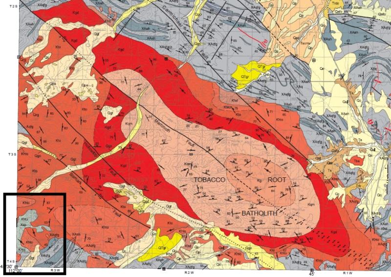
| Geologic Map of part of the Tobacco Root Mountains. Reds and oranges are igneous rocks of the Tobacco Root Batholith, about 75 million years old. Grays are Precambrian rocks, about 1700 to 2500 million years old. Both maps from Vuke et al., 2014, Geologic Map of the Bozeman quad, Montana Bureau of Mines and Geology Open-file map 648. Black box in lower left corner is enlarged below. |
 |
| Oranges (Khto) are Tobacco Root Batholith, grays are Precambrian. X=Paleoproterozoic, about 1.7 to 1.9 billion years old; A = Archean, over 2.5 billion. XA means we aren't really sure. qfg = quartzofeldspathic gneiss, ah = amphibolite and hornblende gneiss. Xsp = Spuhler Peak formation. Branham lakes are blue. |
There isn’t much doubt that the metamorphic rocks there were originally mostly sedimentary rocks, sandstones, shales, siltstones, maybe even a few limestones, and that they were intruded by some igneous rocks like basalt, all before they were metamorphosed. We can infer what these protoliths, the original rocks, were, from the chemistry and mineralogy of the rocks today. So it’s a question that doesn’t matter too much, although it has big implications for the detailed story of this part of the world – when were sediments laid down, when were they metamorphosed. That in turn has implications for the structural and tectonic history, and understanding THAT helps us explore for mineral resources and understand things like earthquake fault distributions.
I’m not going to solve the question by walking up to the Branham Lakes. This beautiful location is about 9 miles or so up Mill Creek, east from Sheridan, Montana.
Most of the major valleys on the flanks of the mountains of southwest Montana held glaciers during the most recent glacial period that ended about 12,000 years ago or so.
 |
| Kyanite, Aluminum Silicate |
Sediments like silts and muds usually contain plenty of silica, fine-grained quartz, but often they have fragments of feldspars or the clays that weather from feldspar, and those minerals contain a lot of aluminum. Under metamorphic conditions, high temperatures and pressures, the aluminum and other chemicals reorganize into minerals that are stable at those temperatures and pressures. There are three minerals, kyanite, andalusite, and sillimanite, which are chemically identical aluminum silicates, Al2SiO5, but which have different crystallography that reflects the details of the pressure-temperature regime in which the aluminum and silica were mobilized. Kyanite is stable at relatively low temperatures, 200 to 700°C, and low to high pressures; Andalusite forms at low pressures and medium temperatures, and Sillimanite forms at high temperatures across a range of pressures. The boundaries between these phases are well known so we can use their occurrence to infer the temperatures and pressures that the rocks reached during metamorphism.
 |
| Tobacco Root Batholith granite with dark xenolith of older rock |
The Archean and early Proterozoic metamorphic events, about 2.5 billion to maybe 1.7 billion years ago, were ancient when the next potential metamorphic event took place, about 76 million years ago.
In the next clip, I made a mistake – I say epidote when I meant to say enstatite. They both start with an E, that’s my excuse! Enstatite is magnesium silicate, and hypersthene, also mentioned in the next clip, is enstatite with iron in it. Both are the kinds of minerals you can get by metamorphosing rocks that have a lot of iron and magnesium, probably NOT simple sediments like shale.
The road to the Branham Lakes, about 9 miles from Sheridan, Montana, is pretty good, and you could probably make it almost all the way in a 2-wheel-drive vehicle if you have decent clearance. I chose to leave my Prius about 2½ miles from the lakes just to be safe, as there are a few dicey stretches, and because it was such a fine day I really preferred to walk. If you go, it would be an unusual year that you’d find the road and lakes snow-free before late June at the earliest, but the setting is spectacular in July and August. I have a few photos from my walk on the blog, history of the earth calendar dot blogspot dot com.
I hope you have enjoyed this little ramble from the Precambrian to the Cretaceous to the glacial period of the Pleistocene. Thanks for listening!
 |
| Lower Branham Lake |