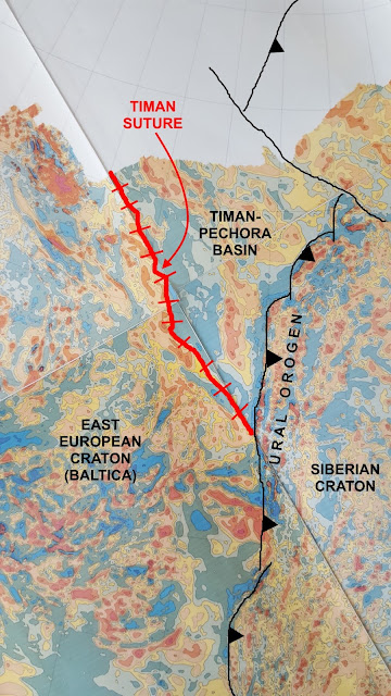
This is part of the magnetic map of the former Soviet Union. It reveals three continental blocks and their amalgamation to form part of Eurasia. The Siberian Craton (a craton is a strong, usually fairly old block of continental crust) collided with and became attached to the East European Craton beginning about 300 million years ago, about the same time as Europe and Africa began to collide with North America to form the Appalachians. Here, the collision produced the Ural Mountains (orogeny means mountain building). The Ural-building collision went on for close to 100 million years.
Much longer ago, at least 520 million years ago and maybe as long ago as 650 million years, a relatively small continental block, labeled “Timan-Pechora Basin” in the image, was amalgamated to the East European Craton. The Timan Suture marks the position of that collision. Today that’s just a range of low hills, but it would have been high mountains at the time of the collision. The Timan-Pechora block was fully part of the East European Craton when Siberia collided with both of them.
For a sense of scale, the distance along the
coastline (edge of data) from the Timan Suture to the thin black line is about
400 miles.
This is a very broad-brush look at these magnetic data (I spent the year 1990 making detailed interpretations of the maps for oil exploration).

No comments:
Post a Comment