Geology

Geology
The 366 daily episodes in 2014 were chronological snapshots of earth history, beginning with the Precambrian in January and on to the Cenozoic in December. You can find them all in the index in the right sidebar. In 2015, the daily episodes for each month were assembled into monthly packages (link in index at right), and a few new episodes were posted from 2015-18. You may be interested in a continuation of this blog on Substack at this location. Thanks for your interest!

Sunday, March 4, 2018

Triassic and Jurassic Vertebrates compilation


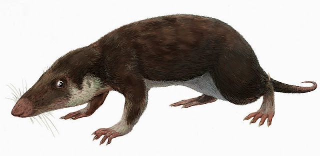
Morganucodon, a possible early mammal from the Late Triassic. Length about four inches.Drawing by FunkMonk (Michael B. H.) used under Creative Commons license


Running time, 1 hour. File size, 68 megabytes.

This is an assembly of the episodes in the original series from 2014 that are about Triassic and Jurassic vertebrates.

As usual, I’ve left the references to specific dates in the podcast so that you can, if you want, go to the specific blog post that has links and illustrations for that episode. They are all indexed on the right-hand side of the blog.

Thanks for your interest and support!


Tuesday, February 27, 2018

Episode 389 Vanadium


Vanadium is a metal, and by far its greatest use is in steel alloys, where tiny amounts of vanadium improve steel’s hardness, toughness, and wear resistance, especially at extreme temperatures. As I reported in my book What Things Are Made Of, more than 650 tons of vanadium was alloyed with iron to make the steel in the Alaska Pipeline, and there’s no good substitute for vanadium in strong titanium alloys used in jet planes and other aerospace applications.

Vanadium isn’t exactly one of the well-known elements, but in terms of abundance in the earth’s crust, most estimates indicate that there’s more vanadium than copper, lead, or tin. But it’s difficult to isolate, and it wasn’t produced chemically as a chloride until 1830, when Swedish chemist Nils Sefström named it for the Norse goddess of beauty, Vanadis, perhaps better known as Freyja. It wasn’t until 1867 that pure vanadium metal was isolated by British chemist Henry Roscoe, whose work on vanadium won him the name of the vanadium mica roscoelite.


As a mineral collector, I’m attracted to vanadinite, lead vanadate, because it forms beautiful hexagonal crystals, often bright red and so abundant from one lead-mining area of Morocco that excellent specimens can be had without mortgaging your house. Some vanadinite crystals are like perfect little hexagonal barrels, and others can form needle-like spikes around a central crystal, making the whole thing look like a cactus with caramel-orange spines.

Some of the vanadium for making steel alloys comes from primary mined vanadinite, but much more was once produced as a by-product of phosphorous manufacture, because it’s commonly associated with phosphate rock. And today, a lot of the world’s vanadium comes from refining crude oil and from fly ash residues, which are products of coal combustion. I got curious about why vanadium metal is so closely connected with these organic deposits.

Crude oil actually has lots of trace elements in it, including metals like gold, tin, and lead, but by far the most abundant are nickel and vanadium, as much as 200 parts per million nickel and 2000 parts per million vanadium in some crude oils, especially heavy, tarry oils like those found in Venezuela. In some oil, the nickel and vanadium can add up to 1% by weight of the oil, an incredibly huge amount. Refining Venezuelan crude gave the U.S. a lot of vanadium back in the late 20th century. But why is it in there?

Oil and coal are both the result of decaying and chemically changing plant matter. Forget dinosaurs; virtually all oil, natural gas, and coal comes from plants – usually marine algae for oil and gas and more woody, land-based vegetation for coal. There’s a class of organic molecules called porphyrins. I’m no organic chemist, but these complex hydrocarbon molecules, made of carbon, hydrogen, oxygen, and nitrogen have boxy ring-like structures with open space in the centers. Chlorophyll and hemoglobin are related chemicals, both of which contain metals in the middle of the structure, magnesium in chlorophyll and iron in hemoglobin. The vacant holes in the centers of porphyrins in crude oil are ideal for trapping metal molecules, and apparently vanadium, in the form of a VO2 ion, is one of the easiest to trap because of its molecular size and electronic valence.

The vanadium comes from the original oil source rock, so there’s quite a range in vanadium content around the world. Heavy oils, like the tars in Venezuela, hold more than fluid oils like those in Saudi Arabia. This has more or less been known since at least the 1920s, and today the vanadium and other metal contents of oils are being used to characterize the original source rocks even when those source rocks no longer exist or are no longer what they once were.

The United States has had no mine production of vanadium since 2013 and even then we were 94% dependent on imports. Today 100% of our vanadium is imported, and we also produce some vanadium from imported crude oil and ash. More than 90% of the world’s vanadium is mined in China, Russia, and South Africa, although the US imports much of what it needs from the Czech Republic and Canada as well as Russia. We also imported enough ash and refining residues to account for 9000 tons of vanadium in 2015, mostly going as I said to making steel alloys. A new emerging use is in high-capacity storage batteries, where vanadium compounds make the electrolyte. These batteries have potential uses for renewable energies such as wind and solar power, and although in 2015 and 2016 several companies were working on prototype designs, they’re still pretty expensive batteries.

Way back in 1971 when I was a teaching assistant for the Indiana University Geologic Field Station, on one mapping project we went to the Mayflower gold mine south of Whitehall, Montana. I collected a bunch of rocks with interesting looking sparkly crystals – some of which I’ve only recently gotten around to really studying. I gave a talk at the 2017 MontanaBureau of Mines and Geology Mineral Symposium on minerals from there that turned out to be vanadium-bearing, including vanadinite, although it’s probably an arsenic-rich variety, and stranger minerals like descloizite, a lead-zinc vanadate, tangeite, calcium-copper vanadate, and some others. I even think there are some tiny bits of roscoelite, the vanadium mica named for the chemist who first prepared vanadium metal.  

Even more exciting for me are some tiny, millimeter-sized red-orange crystals in the specimens I found at the Mayflower Mine. All I knew for a long time was that I couldn’t figure out what they were. By looking at their crystal shapes and properties, I narrowed it down to two very strange and very rare minerals – gottlobite, a calcium-magnesium vanadate, and calderónite, a lead-iron vanadate. Both of these minerals are so obscure I didn’t really seriously imagine I had actually collected one of them. But, thanks to an analysis by Stan Korzeb, the economic geologist at the Montana Bureau of Mines and Geology, it turned out that I did indeed find calderónite, 32 years before it was described as a new mineral in 2003. Stan’s analysis in January 2018 used EDX, or energy-dispersive x-ray spectroscopy, a technique that gives not only the elements present in a mineral, but their relative proportions, which allowed Stan to calculate the chemical formula. The lead-iron vanadate calderónite he found is intergrown with descloizite, a lead-zinc vanadate. This probably indicates changing iron-zinc concentrations in the fluids that precipitated the minerals. This represents just the 11th documented calderónite occurrence in the United States and the second in Montana. Stan identified the first in Montana in the fall of 2017.

It’s an obscure mineral, and the crystals are tiny, but it made this mineral collector’s day.
—Richard I. Gibson

Link:

Tuesday, February 20, 2018

Episode 388 Folds in Algeria


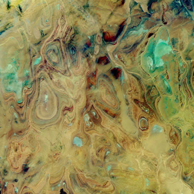
You may have seen some of the spectacular images of the earth in southern Algeria, curves and colors like some Picasso in the opposite of his cubist period. If you haven’t, check out the one from NASA, below. 

The ovals and swirls, with their concentric bands, are immediately obvious to a geologist as patterns of folds, but not just linear folds like many anticlines and synclines form. These closed ovals represent domes and basins – imagine a large scale warping, both up and down, in a thick succession of diverse sedimentary rocks, like sets of nested bowls, some of them right-side up and some inverted, then all sliced off halfway through.

But “obvious to a geologist” has plenty of limitations in a space image. Without knowing more information, it’s difficult to be sure if an oval is a basin or a dome. And you can speculate, but without some ground truth, it’s challenging to be sure what the rock types are.

Ahnet-Mouydir, Hoggar Mountains, Algeria. NASA image - source

This area, called the Ahnet-Mouydir, on the flank of the Hoggar Mountains close to the middle of the Sahara Desert, is remote, inhospitable, and arid, and called the “land of terror” for a reason. The rocks represent a thick sequence of marine sandstones, shales, and limestones, spanning a huge range of ages, from at least the Ordovician to the early Carboniferous – 150 million years or more, a great chunk of the Paleozoic era.


The core of the Hoggar Mountains is an old Precambrian block, not as big as the cratons and shields that form the hearts of most of the continents, but otherwise similar. It might have been something like a microcontinent that became amalgamated into the growing supercontinent of Gondwana about 600 million years ago. After that amalgamation, seas came and went much like they did in western North America throughout much of the Paleozoic era, laying down the sediments that became the rocks we see today in the northern Hoggar Mountains.

That’s all well and good – but here’s the next question, how did the rocks get deformed into these oval domes and basins? If you imagine the kinds of collisions that are typical on earth, you think of linear or curvilinear things – island arcs, edges of continents and such – that when they collide, are likely to make linear belts of deformation. This is why so many mountain ranges are long, linear features, and the folds and faults that make them up also tend to be linear. Domes and basins happen, but that seems to be almost all we have here in these mountains.

We have to look for a deformational event that is later than the youngest rocks deformed. So if some of these rocks are as young as early Carboniferous, about 340 million years old, the mountain-building event that fills the bill is the Hercynian Orogeny, where ‘orogeny’ just means mountain-building.

The Hercynian, at about 350 to 280 million years ago, represents the complex collision between Gondwana and the combined North America and Europe, which were already more or less attached to each other. The leading edge of Gondwana that collided was in what is now North and West Africa, and the collision produced mountain ranges all over – the Alleghenies in the central Appalachians in North America, and a complex swath of mountains across central Europe, from Spain, across France to northern Germany and into Poland, as well as elsewhere. In Africa, the most intense squeezing was at the leading edge, in what is now Morocco and Mauritania, colliding with North America, and northern Algeria, impacting Iberia.

The basins and domes of southern Algeria that we’re trying to understand are 1500 kilometers or more from that leading edge of continental collision. So I think – and full disclosure, I’ve never really researched this area in detail – that what must have happened is that that distant hinterland wasn’t pushed into tight, linear belts like those we find along the lines of collision, but the force was enough to warp the sediments into these relatively small domes and basins. Alternatively, it might be possible that the brittle Precambrian rocks beneath the sedimentary layers broke from the force of the collision, so that the sedimentary layers draped over the deeper brittle surface like a carpet lying over a jumble of toy building blocks – some high, some low.

The latter idea, that the brittle basement rocks were broken and pushed upward with the sedimentary layers draped over them is supported by research published in the journal Terra Nova in 2001. Hamid Haddoum and colleagues studied the orientations of folds and faults in this area, trying to figure out the orientations of the stresses that caused them. Their data show a shortening direction – which means compression, or squeezing – during early Permian time oriented about northeast-southwest. That is consistent with the collision that was happening at that same time between what is now Senegal and Mauritania, in westernmost Africa, and the Virginia-Carolinas region of what is now the United States. Haddoum and his colleagues show cross-sections with basement upthrusts, basically high-angle reverse faults where older rocks are squeezed so much that they are pushed up and over younger rocks. This is quite similar to the Laramide Orogeny in the western United States about 80 to 50 million years ago, but this compression was happening about 280 million years ago as the supercontinent of Pangaea was assembled during the early Permian Period. Both represent deformation at relatively great distances from the lines of continental collision. In the case of the Laramide in western United States, one idea for transmitting the stress so far from the collision is that the subducting slab of oceanic crust began to go down at a relatively gentle angle, even close to horizontal, creating friction and stress further away from the subduction zone than normal. Whether that’s the case here in southern Algeria isn’t clear for this Hercynian collision.

I wouldn’t think of this area as high mountains, such as those that must have formed along the lines of Hercynian collision. Maybe more like warped, uplifted plateaus – but whatever they were, they were certainly subject to erosion. Erosion probably wore the domes and basins down to a common level, so that the nested bowls were exposed in horizontal cross-section – which for geologists is the equivalent of a geologic map. And that’s what the beautiful photos reveal.

The area might have been planed off even more by Permian glaciers during and after the Hercynian mountain-building events. But then, during the Mesozoic era, seas returned to the region and all this mess of eroded domes and basins was buried beneath even more sediments. Sometime relatively recently, during the Cenozoic era, the past 65 million years, everything was uplifted at least gently, so that the highest parts – including today’s Hoggar Mountains, were stripped of the younger Mesozoic sedimentary rocks, revealing the much older Paleozoic rocks in the domes and basins.


—Richard I. Gibson

Link: