Geology

Geology
The 366 daily episodes in 2014 were chronological snapshots of earth history, beginning with the Precambrian in January and on to the Cenozoic in December. You can find them all in the index in the right sidebar. In 2015, the daily episodes for each month were assembled into monthly packages (link in index at right), and a few new episodes were posted from 2015-18. You may be interested in a continuation of this blog on Substack at this location. Thanks for your interest!
Showing posts with label Mississippian. Show all posts

Tuesday, December 19, 2017

Episode 379 Gondwana Glaciation


Today’s episode, number 379, is about glaciers in what is now the Sahara Desert, and we’re going back 340 million years, to the Mississippian or Early Carboniferous Period of the Paleozoic Era.

In the original daily episodes of this podcast back in 2014, when we got to the Mississippian in June, I had a very brief episode about glaciers in Australia and South America. They probably represented an early pulse of the well-known later glacial period during the Permian, and the glaciation provided evidence for the existence of the supercontinent of Gondwana, which was situated more or less over the south pole at that time, about 340 million years ago. 

Gondwana consisted of the continents and smaller blocks we know today as South America, Africa, Arabia, Antarctica, India, and Australia, and the pole was located somewhere in south-central Africa, so it should come as no surprise that some recent work by Daniel Le Heron at the University of London, published in the journal Geology in November 2017, reports evidence for an extensive ice sheet in what is now northern Chad, in the modern Sahara Desert.

Permian Gondwana reconstruction and inferred ice cap (blue outline) from A. du Toit, South African geologist, 1937 (Our Wandering Continents). Du Toit's work was remarkably prescient. The map above differs only slightly from modern reconstructions of Gondwana. The red oval shows the general area where Le Heron (2017) infers a small ice sheet in Carboniferous time. 

Le Heron described belts of sinuous lineaments carved by ice in belts five to 12 kilometers wide and spread over an area of more than 6,000 square kilometers. The features cut into an ancient surface that is interpreted to represent the landscape over which the glaciers flowed during that Early Carboniferous time. He suggests that the ice sheet extended to the west to cover much of what is now Niger, and that the glaciers flowed northward into the sea. The coastline then was also in far northern Chad, so the glaciers probably reached the ocean.

The present-day surface of the earth in northern Chad is actually an exhumed, an uncovered, ancient landscape that formed about 340 million years ago when those glaciers scoured the land. The surface was buried by later sediments which have since been eroded away.

I don’t think the causes for this glacial episode are well understood, although there’s been a lot of work done on it. One of the most recent reports, by Yves Goddéris & Yannick Donnadieu and their colleagues writing in Nature Geoscience in April 2017, suggests that the onset of glaciation was the result of tectonic activity. Just before the ice age got going, the Hercynian Mountains had been uplifted because of continental collisions in many parts of the world. As soon as mountains are uplifted, they begin to erode, and a lot of erosion tends to reduce atmospheric carbon dioxide because there’s a lot more material, the sediment, to react with the CO2. Goddéris and his co-workers think CO2 levels fell enough to trigger the formation of glaciers in the mountains, and ultimately by Permian time, to form extensive ice sheets that covered a huge area of Gondwana.

According to their model, the glacial period ended when the mountains had been eroded enough to affect the carbon cycle and allow CO2 levels (and overall temperatures) to rise again. The end of glaciation was also likely affected by the final amalgamation of the supercontinent of Pangaea, which changed climates to more extensive arid conditions.

If you are interested in more about the Mississippian or Early Carboniferous Period, search the archives for June 2014. All 30 episodes that month were about the Mississippian.
—Richard I. Gibson


Tuesday, July 7, 2015

The Mississippian Episodes


Running time 1 hour 30 minutes

This episode is the sixth monthly package that combines the daily episodes for June 2014, covering the Mississippian Period of the Paleozoic Era. I apologize for not getting this assemblage done on time – my summer has been pretty complicated.

As usual, I’ve left the references to specific dates in the podcast so that you can, if you want, go to the specific blog post that has links and illustrations for that episode. They are all indexed on the right-hand side of the blog.

Thanks for your interest in this project. As the year continues, there will be occasional new episodes in addition to these monthly assemblies.

If you have questions or comments, please let me know, either here on the blog – there’s a page for Questions– or contact me by email at rigibson at earthlink.net. I’ll try to respond. You can of course also leave a review on iTunes. I really do appreciate your feedback.

—Richard I. Gibson

Monday, June 30, 2014

June 30. The end of the Mississippian


As we discussed at the start of the Mississippian, it’s only in the United States that Mississippian and Pennsylvanian are treated as full periods of geologic time. In the rest of the world, the two together are called the Carboniferous.  

In the U.S. the distinction is made as much as anything because the two periods contain distinct kinds of rocks. The Mississippian is dominated by the shallow-water limestones we heard so much about this month, while the Pennsylvanian contains the coal that gives the Carboniferous its name. It’s true that the early Carboniferous in much of the rest of the world contains less-abundant coal than the later part of the period, the part that correlates with the Pennsylvanian in the United States, but it’s still treated as a single period worldwide.

I think the different terminology has to do with the history of usage as much as anything; in 1906, geologist T.C. Chamberlain pointed out that the rocks of Mississippian and Pennsylvanian age are not only significantly different in rock type but that there is a break – an unconformity – between them, so the two were recognized as periods in the U.S. That break more or less represents the onset of the Appalachian and Ouachita Orogenies which began to create significant uplifts in both the east and south, and to some extent the west of the North American Continent. The Variscan Orogeny was doing the same thing in southern and central Europe, but nonetheless, European geologists never embraced the idea of breaking the Carboniferous into two distinct periods. So, officially in terms of worldwide use, the Mississippian and Pennsylvanian are the equivalents of the Early Carboniferous and Late Carboniferous. Or you can call them sub-periods, or if you are in the United States, call them periods of geologic time. It really doesn’t matter as long as we can communicate!

So tomorrow we’ll enter the Pennsylvanian.

* * *

Today, June 30, in 1908, an object hit the earth near the Stony Tunguska River in Siberia. Something like 2000 square kilometers – 800 square miles – of forest were flattened. It could hardly have been in a more remote area, and consequently there were no known human fatalities. The explosion was almost certainly the result of the breakup in the atmosphere of a comet fragment or asteroid or meteor, although there have been any number of speculations as to the origin, ranging from black holes to alien space ships. The air burst probably occurred 5 to 10 kilometers above the surface, and the object was probably between 60 and 200 meters across, or about 600 feet at most. But it still represents the largest impact event on Earth in recorded history.

—Richard I. Gibson

Sunday, June 29, 2014

June 29. Mississippian fish


Goologongia


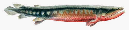
Rhizodonts were fish that grew to as much as 7 meters long, around 22 feet, the largest freshwater fish known. They got their start during the Devonian, but really proliferated during the Mississippian, only to go extinct by the end of the Pennsylvanian. 

The rhizodonts were a fish group whose limbs – fins – showed close affinities to the tetrapods, the primitive amphibians that were invading the land during the Mississippian. The fins, especially the front fins, were strong, with strong supporting tissues, and the rays of the fins were very much like fingers.

They had highly maneuverable jaws, and they were the greatest predators in the Mississippian lakes and rivers where they could have attacked things like lungfish and early amphibians. Some species had large tusks, and the name of the group, rhizodont, means “root-tooth” because their long teeth, some as long as 15 centimeters, or 6 inches, had distinctive root systems, another trait that connects them to the tetrapods and later animals.

Study of rhizodonts is an active area of paleontology today because of their relatively close relationship to the tetrapods, the ancestors of amphibians, reptiles, birds, and mammals. The fossil record of tetrapods, which began during the Devonian, still contains many gaps even millions of years later in the Mississippian.
—Richard I. Gibson

Image from Palaeos.

Reference: Gaining Ground: The Origin and Evolution of Tetrapods, by Jennifer A. Clack, Indiana University Press, 2012, p. 75-78.

Saturday, June 28, 2014

June 28. Corals


Lithostrotion basaltiforme
The extinction at the end of the Devonian decimated reef-building organisms such as corals. Extinction events typically see a rebound of life following the relatively brief period of extinction, and during the Mississippian corals did begin to make a comeback. We talked about the relatively small carbonate build-ups called Waulsortian Mounds on June 11. Those piles of mud may have been stabilized by the skeletons of animals such as crinoids and corals, but they were nothing like the huge edifices constructed by animals during the
Devonian, and the even larger ones to come in the Permian and even today.  

Corals were still abundant in those warm Mississippian seas, and both colonial and solitary types were common. Tabulate corals were colonial, tall columns growing together with horizontal segments, tabulae, providing the platform on which the individual zooids lived. One species, named Lithostrotion basaltiforme, has a remarkably similar appearance to the polygonal columns of basalt that form as a result of cooling – though the corals are much smaller.

There are biologic features in the Mississippian that can truly be called reefs, although purists might call them bioherms, meaning a relatively tall structure that might be a pile of material or a construction like a true reef, or a combination of both. The words “reef” and “bioherm” are sometimes used almost interchangeably, but to me a reef means a relatively large structure that is mostly composed of the actual skeletons of the animals that lived there, rather than a pile of debris. I’m not a specialist in this area, so take that as just my opinion about the terminology.
—Richard I. Gibson

Drawing from an old text (public domain)

Friday, June 27, 2014

June 27. Gastropods


Bellerophon gibsoni, Mississippian gastropod
We haven’t said much about gastropods, snails, in our journey. They have a long history, extending back at least to the Cambrian, and while they have a wide variety of shell forms, by Mississippian time many of the shapes that survive to the present day had been established.  

As with other marine invertebrates, gastropods thrived in the warm, shallow Mississippian seas. Some are known that were three inches or more across, relatively large for Mississippian gastropods – but today’s conchs are also gastropods and some of their shells grow to a foot long or more.

Gastropods are a class of the phylum Mollusca, which includes cephalopods – octopuses and squids – and bivalves including clams and scallops. Gastropods comprise about 80% of all mollusk species, and there are more than 60,000 known species today. More than 15,000 species are extinct and are known only from the fossil record.

During the Mississippian most or all gastropods were aquatic. Some of the earliest land-dwelling snails are known from the coal measures of Europe, the late Carboniferous or Pennsylvanian Period, which we will get to next month. Even then, land snails were rare for many more millions of years.
—Richard I. Gibson

Drawing of Mississippian gastropod from an old textbook (public domain)

Thursday, June 26, 2014

June 26. Leadville


Ore zones in black
Lead was discovered at Leadville, Colorado, in 1874, and has continued sporadically over time more or less to the present. The host rock for the ore is the Mississippian Leadville Limestone, which is one of the formations equivalent to the Madison Limestone that covered so much of North America during early to middle Mississippian time.  

As usual, the prospectors in the Leadville area were seeking gold, and the exploitation of lead was a later development.

The ore is related to igneous intrusions that forced their way into the limestone, forming sills, which are igneous bodies that are parallel, or concordant, with bedding planes in sedimentary rocks. The molten material came in along the weak zones that bedding planes created. The lead was most likely deposited by hot waters associated with the magmas. The water dissolved parts of the limestone, and the ore minerals, such as galena, lead sulfide, were deposited in the fissures and cavities that had been dissolved. The magmas are of Tertiary age, so the ores were deposited around 300 million years after the limestone formed during the Mississippian.

Zinc and silver are often associated with lead deposits, and the total cumulative production at Leadville, Colorado, includes more than 240 million ounces of silver, making Leadville more famous for silver than for lead. The district also produced more than 700 million tons of zinc, and almost a billion tons of lead.

The Leadville Limestone in Utah was eroded and dissolved by a period of karst formation, and the resulting porosity makes the Leadville a target for oil and gas exploration in Utah.
—Richard I. Gibson

Leadville history 

Cross section from Argall, in Ries (1925). Public domain.

Wednesday, June 25, 2014

June 25. Glaciers in Australia and South America


After the end of the glacial period at about the end of Devonian time, most of the Mississippian was ice-free around the world until near the end of the period. There is evidence for episodic glaciation in Australia and South America at this time.  

It’s possible that the Mississippian glaciers were predecessors to the well-defined Permian glaciation, although that ice age was still at least 25 million years in the future as the Mississippian ended. The onset of glacial episodes would have contributed to sea-level changes that in turn would be contributing factors in the increase in clastic sediments in Late Mississippian time. The shallow seas so common earlier in the period would have become reduced in size as sea levels fell.

One possible contributing factor in the beginning of the glacial period is the tectonic closing of the Tethys Sea and the ocean between Gondwana and North America. Disrupting what was a major equatorial ocean circulation pattern could have impacted global distribution of heat in the oceans and therefore in the atmosphere, and could have helped continental ice sheets to form and grow.
—Richard I. Gibson

Technical paper

Tuesday, June 24, 2014

June 24. Cave passages


We talked about Mammoth Cave the other day, but here’s a little more about its development. Cave passages tend to be linear, in part because moving water preferentially dissolves limestones along lines of weakness, such as linear joints or fractures and along bedding planes.  

Sometimes in places where joints and fractures are regularly spaced and relatively rectilinear, forming rectangles in map view, a cave system might approximate that pattern too. But water isn’t usually strictly limited to the joints, and collapsing caves can create new patterns as well. The map above of Mammoth Cave was compiled in 1897. There’s a certain degree of regularity, and several directions such as northeast-southwest that seem to predominate, but there’s actually quite a wide variety in the development of the cave passages dissolved in Mississippian limestones. Regular patterns do happen, but natural systems tend to be complex enough that regularity is usually the exception rather than the rule.

* * *

Today’s birthday is David Dale Owen, born June 24, 1807, near New Lanark, Scotland. He was the son of Robert Owen, a reformer who established a social experiment at New Harmony, Indiana, in 1825. It was an attempt to establish a utopian society. It was an economic failure but New Harmony became a cultural and educational center, noted for scientific research. David Dale became a prominent geologist, doing some of the first work in the Midwestern United States. He was the State Geologist of Indiana, Kentucky, and Arkansas at various times between 1837 and his death in 1860.
—Richard I. Gibson

Monday, June 23, 2014

June 23. Appalachian in Iowa


The effects of continent-continent collisions can be felt far into the continents that are involved. Today’s collision between India and Eurasia, which has been going on for 30 or 40 million years, has helped to produce extension 2500 miles, 3700 kilometers away from the collision, at Lake Baikal in Siberia. 

The Appalachian-Ouachita Orogeny had impacts as far away as Iowa quite early in the collision. Early Mississippian marine carbonate rocks were tilted and folded and uplifted and eroded before Pennsylvanian coal-bearing strata were deposited. There’s a pretty good unconformity between those sets of rocks.
—Richard I. Gibson

Reference: Coal Deposits of Iowa, by C.R. Keyes, Iowa Geological Survey, 1894.

Sunday, June 22, 2014

June 22. Late Mississippian Lands and Seas


By late Mississippian time, around 325 million years ago, the extensive warm shallow seas that covered much of North America were becoming restricted. The sedimentary rocks were less often the limestones we heard so much about for most of this month, and more the shales we discussed on June 17. More clastic sediment reflects the onset of uplift of lands around the marine areas.

In North America, in both the east and south-central part of the continent, collision with the northwestern margin of Gondwana was beginning. In the east, this was largely along the same zone where previous collisions, from the Taconic Orogeny at the end of the Ordovician to the Caledonian and Acadian Orogenies in the Silurian and Devonian had produced episodic ongoing uplifts. This is the beginning of the Appalachian or Alleghenian Orogeny, the main continent-continent collision between North America and Gondwana.

Another aspect of that collision was beginning in what is now Oklahoma, Texas, and Arkansas, where it is called the Ouachita Orogeny. The uplifts there led to the deposition of the Barnett Shale in the Fort Worth Basin, which today is a significant source of natural gas production.

The Tethys Ocean between Eurasia and Gondwana was also closing, and aspects of that collision during the latter part of the early Carboniferous, the equivalent of the Mississippian Period, are the Variscan Orogeny in Europe. This was definitely not a simple collision, as there were many isolated microcontinental pieces, oceanic crust, and island arcs involved, so parts of the Tethys remained open while other parts were closing. Parts of the Tethys Ocean still exist today, beneath the Black Sea, the southern Caspian Sea, and in the deeper basins of the Mediterranean.

While the timing of all these events varies by a few tens of millions of years, I think it’s safe to say that the collision between Laurasia – North America plus Eurasia – and Gondwana was definitely underway by late Mississippian time. We’ll hear more about it over the next month or so.

—Richard I. Gibson

Reference: AAPG Memoir 43, Evolution of the Arctic-North Atlantic and the Western Tethys, by Peter A. Ziegler (1988).

Saturday, June 21, 2014

June 21. Mississippian amphibian tracks


The Mauch Chunk formation in Pennsylvania, Maryland, and West Virginia contains relatively coarse clastic sedimentary rocks – clastic means broken, and the broken pieces were sand grains, silt, and pebbles that became sandstone, siltstone, and conglomerate. The rocks are mostly reddish, indicating oxidized iron and indicating an environment that was alternately under water and exposed to air. The most likely depositional setting was a delta or the low shore of a shallow sea, or possibly a swamp that was periodically inundated and then drained. Some of the rocks are green, indicating reduced iron, which forms in the absence of oxygen in a setting like a swamp.  

The beds are late Mississippian, about 320 to 340 million years old, but the youngest layers may be from the early Pennsylvanian. The coarser sediments also tend to be from the upper part of the formation and may reflect the onset of the Alleghenian or Appalachian Orogeny, the “big crunch” of mountain building that represents the collision of Gondwana with eastern North America. That collision was probably underway by about 325 million years ago, near the end of the Mississippian.

from Bronson, 1910
One of the coolest things about the Mauch Chunk is that it contains indications of land-walking animals, very likely amphibians. Footprints of tetrapods, four-footed animals, have been found impressed in sandstone with ripple marks. The ripple marks mean the sediment had been under water recently, but the well preserved footprints were made in the sand when it was exposed to air – they would not have been so well defined underwater.

In 1908 E.B. Branson and his colleagues from Oberlin College found such prints in late Mississippian rocks in Virginia. The animal’s feet were about 6 centimeters long, about 2½ inches, and they had five toes, at least some of which were webbed. The animal was probably lizard-like, although in the early discoveries they found no drag marks from tails.

In addition to footprints, impressions of nearly complete animals have been found. There’s a link on the blog to a 2007 report on those body impressions. The report draws possible conclusions about mating behavior based on the nature of those impressions.

The name Mauch Chunk is from Native American Lenape words meaning “bear place”. Today the community that once had that name is called Jim Thorpe, Pennsylvania, for the Olympic athlete.  

* * *

On June 21, 1887, Norman Levi Bowen was born in Kingston, Ontario. N.L. Bowen was an experimental petrologist who studied the ways minerals crystallize from molten magma. Much of his work was at the Geophysical Laboratory at the Carnegie Institution in Washington, D.C. He established Bowen’s Reaction Series, an explanation of how various minerals form based on the temperature of a cooling magma. The reaction series helps explain why some minerals are commonly associated with each other while others, such as quartz and olivine, are rarely if ever found together. It also has implications for the stability of rocks and how they are likely to erode and alter under weathering conditions on the earth’s surface or during later metamorphic events.

Today is also the anniversary of a devastating earthquake in 1990, in northwestern Iran. The death toll was 40,000 to 50,000, and several large cities and many villages were almost completely destroyed. The quake was centered in the western Alborz Mountains along the Caspian Sea, where a relatively small continental block is trapped between the colliding Arabian Plate to the south and the Eurasian Plate to the north. The southern Caspian Sea is a small bit of dense oceanic crust, a remnant of the Tethys Ocean that lay between Gondwana and Eurasia. The microcontinent that forms today’s Iran is being pushed up and over that little oceanic crustal fragment. This has uplifted the Alborz Mountains – and puts volcanoes in them – while the Caspian Sea and most of its margins are below sea level. The high point in these mountains, Mount Damavand, is about 5600 meters or 18,000 feet above sea level, and it rises to that height within about 80 kilometers or 50 miles from the below-sea level coast, making this one of the steepest mountain fronts in the world.
—Richard I. Gibson

Amphibian fossil body impressions (2007 report)

Photo taken from Journal of Geology, v. 18, #4, p. 357, 1910, report by Branson (volume in author’s collection).

Friday, June 20, 2014

June 20. Mammoth Cave


Photo by Navin75, via Wikipedia, under CC-by-SA license
Mammoth Cave, Kentucky, with more than 400 miles of mapped passages and connected to the Flint Ridge cave system, is the longest known cave in the world. Dissolution of the St. Louis and St. Genevieve Limestones of Mississippian age, about 325 to 350 million years old, produced the cave. The process may have begun as much as 30 million years ago, but most of the cave’s development is less than one million years old. Mammoth Cave is a “living cave” where dissolution and precipitation of cave features by running water are still continuing today.  

The cave includes an underground river and large rooms dissolved from the limestone, but which are often partly filled by redeposited calcium carbonate, calcite, in the myriad of forms you know about in caves – stalagmites, stalactites, flowstones, and much more that give the cave its beauty.

In 1972, members of the Cave Research Foundation exploring the Flint Ridge cave system discovered the connection between those caves and Mammoth Cave, making it by far the longest cave in the world. Steve Wells, a fellow geology student with me at Indiana University, was part of the team that pushed the connection. Steve and I were teaching assistants at the Indiana University Geologic Field Station, and he went on to become the President of the Desert Research Institute in Nevada.

Mammoth Cave was a commercial resource in the early 19th century, and during the War of 1812 it was sold several times as a source of nitrates to make gunpowder. Slaves mined the ore, but when the price of saltpeter, calcium nitrate, fell after the war, it had a long history as a private tourist attraction. It didn’t become a national park until 1941.

* * *

Francis Pettijohn was born June 20, 1904, at Waterford, Wisconsin. His work focused on sedimentology, the processes that result in sedimentary rocks.

—Richard I. Gibson

Reference: Geology of Mammoth Cave National Park by Ann Livesay, 1962 

Photo by Navin75, via Wikipedia, under CC-by-SA license

Thursday, June 19, 2014

June 19. Crinoids


Actinocrinites gibsoni, Montgomery Co., Indiana
Crinoids really thrived in the warm shallow Mississippian carbonate seas of central North America. At Crawfordsville, Indiana, there’s a lagerstatten – an assemblage of fossils that is remarkable in the completeness and preservation of the fossils. It has lots of crinoids, with the fine details of their arms and other structures remarkably well preserved. They lived about 340 million years ago, a time called the “Age of Crinoids,” at least in Indiana and much of the rest of the region covered by those seas. Crawfordsville crinoids are found in museums of paleontology around the world.  

A picture is worth a thousand words - check the links below. 

—Richard I. Gibson

Photo galleries:
Virtual Fossil Museum 

Indiana Fossils website 

Wednesday, June 18, 2014

June 18. Karst topography


Karst topography develops in areas underlain by soluble carbonate rocks like limestone. In some areas, the rock is mostly dissolved in the subsurface, forming caves and sinkholes, common in Indiana and Kentucky and Florida and many other places around the world. 

Karst topography in China
In parts of Puerto Rico, extremely high rainfall, more than 65 inches a year, helped dissolve most of the limestone leaving behind the parts that were slightly more resistant. The residual hills are called haystacks or pepino hills and sometimes they can reach mountainous proportions, hundreds of feet high and often with nearly vertical flanks. China also has some amazing karst mountains.

The name karst comes from the Karst Plateau in the Dinaric Alps of Slovenia, whose name comes from a German word of probable Slavic origin meaning “a bleak, waterless place.” That’s something of an ironic name since it was an abundance of water that caused the topography. But in many karst areas, much of the water flows underground because of the subterranean caves and even rivers. Lost River, in southern Indiana, is lost because it flows on the surface for a distance, but then plunges underground for several miles. Because of the subterranean drainage, the surface may have few or no lakes as well, so karst plains can indeed seem waterless. 

—Richard I. Gibson

Photo of karst topography in China by chensiyuan via Wikipedia, under Creative Commons license.

Tuesday, June 17, 2014

June 17. Shales


You’ll probably be happy to have a break from all the Mississippian limestones. Today’s topic is shales. Mississippian shales in the United States have become pretty important as oil and natural gas source rocks and as tight reservoirs in various places.  

The Heath Formation in central and eastern Montana is a world-class source rock, containing as much as 26% total organic carbon. You may recall me raving about the Chainman Shale in Nevada, which has as much as 8% total organic carbon. The Heath formation has some interbedded carbonate rocks, similar to the interbedding of shale and dolomite in the Bakken Formation, and using horizontal drilling techniques, some wells in the Heath produce close to 500 barrels of oil per day. But it’s not nearly as uniform and prolific as the Bakken in North Dakota, leading to a 2013 headline in the Billings Gazette about the Heath, indicating that the “Shale formation in Montana frustrates oil drillers.” In mid-2013 there were only a dozen producing wells, and the most recent discoveries only yielded around 20 barrels a day. It’s not worth spending $5 million on a well for that kind of return. Explorers haven’t given up, but for now the Heath is on the back burner.

The Heath Formation is late Mississippian in age, about 320 to 340 million years old. It’s about the same age as the Barnett Shale in Texas, the Fayetteville Shale in Arkansas, the Chainman Shale in Nevada, and other shales. They all formed in basins along tectonically active margins of North America, although some were more active than others. The standard view of these organic-rich shales is that they formed in deep water, poorly oxygenated, and stagnant. Recent studies seem to suggest that it was more complicated than that, and that there might even have been some periods of wave erosion in the deposits at times, so the water must have been relatively shallow for that to happen.

In 2013, the Barnett Shale in the Fort Worth Basin of Central Texas produced about 4.5 billion cubic feet of natural gas per day, almost 7% of all the natural gas produced in the United States. The Marcellus Shale, which we talked about last month, was the nation’s leader in natural gas production.
—Richard I. Gibson

References:
Multiscale Erosion Surfaces of the Organic-Rich Barnett Shale, Fort Worth Basin, USA
Mohamed O. Abouelresh, 2013, Journal of Geological Research


Map from USGS

Monday, June 16, 2014

June 16. Indiana Limestone


Much of the Mississippian limestone in southern Indiana is uniform in its color and texture, properties that make it an excellent building stone. It’s used in many monument facings too. The Empire State Building, National Cathedral, Chicago Public Library, Metropolitan Museum of Art, the new Yankee Stadium, and the roof of the immigration building at Ellis Island are all Indiana Limestone. 35 of the 50 state capitol buildings feature Indiana limestone. 

Sanders Quarry in Salem Limestone
The rock is more technically known as the Salem Limestone, which formed in the warm, shallow Mississippian seas about 335 to 340 million years ago. The region was distant enough from land that very little detritus washed into the lime, so the resulting rock is more than 97% pure calcite, calcium carbonate. The rock is fossiliferous, but many of the fossils are of tiny, even microscopic animals called foraminifera. They are one-celled organisms that made calcareous shells. Most are no more than a millimeter across.

From the building stone point of view, irregularities like fossils aren’t as important as the fact that the Salem Limestone has few bedding planes to disrupt the rock. It’s massive, so blocks of the limestone can be cut out for building stone and for decorative facings. Stone used for these purposes is called dimension stone in the industry, to differentiate it from crushed stone used for things like aggregate in concrete. The rock has been quarried since 1827, and by the 1920s, something like 80% of the limestone quarried in the United States for dimension stone came from southern Indiana, mostly around the towns of Bloomington and Bedford. There are still 9 active quarries in the area.

* * *

Today’s birthday is George Gaylord Simpson, born June 16, 1902, in Chicago. He was a prominent and influential paleontologist who contributed greatly to evolutionary theory regarding the details of how evolution takes place. He spent most of his career at Columbia and Harvard and the University of Arizona.

—Richard I. Gibson

Reference: Indiana limestone 
Sanders Quarry photo by Sphinxcat via Wikipedia (public domain).

Sunday, June 15, 2014

June 15. Mississippian Plate Tectonics


I’ve said for months that Gondwana is coming toward southeastern North America. It’s still coming, but the remaining ocean between the two continents was really pretty narrow by middle Mississippian time.

The Supercontinent of Gondwana included South America, Africa, Arabia, India, Antarctica, and Australia, plus a few additional bits. One of the most interesting bits, from North America’s point of view, was a triangular zone between what is now west Africa and northern South America, along the Venezuelan coast. That triangular zone included what is now Florida and southern Georgia and parts of Alabama and the Bahamas. It was absolutely part of Gondwana at this time, but fear not, we’ll get it fairly soon.  

North America was tilted relative to its present geography, so that the Mississippian equator ran more or less through the middle of the continent, with what is now the east coast forming a southern coastal edge to the continent. The northeastern part of North America – the Maritime Provinces of Canada, Newfoundland, Labrador, and Greenland, were still pretty firmly attached to Europe by the remnants of the Caledonian Mountains, even though they were fairly old by Mississippian time.

The central part of Europe, France, central Germany, and points east, were assembling as a result of small continental blocks that had been shed off the northern flank of Gondwana colliding with the margins of Baltica. What’s now the Iberian Peninsula, Spain and Portugal, was involved in a complex mountain belt called the Variscan Orogeny, which won’t really culminate until the late Carboniferous and Permian Periods, 20 to 50 million years after the end of the Mississippian or early Carboniferous.

* * *

On June 15, 1991, Mt. Pinatubo on Luzon Island in the Philippines reached the climactic phase of a multi-day eruption. Pinatubo had been inactive in recent memory until the 1991 events, and the mountain was deeply eroded and supported extensive forests and human populations.

The eruption ejected huge quantities of ash, and the reported death toll of about 900 was largely the result of buildings collapsing under the weight of the ash.

Evacuations saved thousands, but the lives of pretty much everyone in the region of the eruption were severely disrupted. The volume of ejected material was the second greatest in the 20th century, estimated to be a bit less than the eruption at Katmai, Alaska, in 1912, which we discussed a week ago. The ash and especially the aerosols Pinatubo put into the atmosphere did have global climatic impacts, reducing the average global temperature by almost a degree Fahrenheit or a half degree Centigrade.


—Richard I. Gibson

Early Mississippian map

Reference: AAPG Memoir 43, Evolution of the Arctic-North Atlantic and the Western Tethys, by Peter A. Ziegler (1988).

U.S. Geological Survey Photograph of Pinatubo eruption in 1991 taken by Richard P. Hoblitt.

Saturday, June 14, 2014

June 14. Mississippian chert


First, my disclaimer about the time scale of this calendar of earth history. It’s not at a proper scale. If it were, we’d be in the Precambrian until mid-November. So I’ve arbitrarily assigned the Precambrian to January, the Cenozoic Era to December, and the months between are the periods of the Paleozoic and Mesozoic Eras. It’s June, and that means we’re in the Mississippian Period.


We’ve talked a bit about chert before, but today’s short episode is to say a little more about it.

Chert, fined-grained impure silica, SiO2, appears in sedimentary rocks in two ways. It can form when silica-rich waters percolate through the rocks after they have solidified, with the chert deposited in openings within the rock. And it can be an original part of the rock, deposited at the same time as the rest of the sediment.

Radiolaria
Chert does appear in sedimentary rocks earlier in the Paleozoic era, but it’s really quite rare until the Mississippian Period. Tiny animals called radiolarians secrete siliceous shells. Radiolarians span the entire time from Cambrian to present, but they may have increased in abundance during the Mississippian so that their skeletal remains could have contributed to the increased abundance of chert in the Mississippian rock record, but I’m not sure if that is the explanation for Mississippian chert.

Radiolarian remains today on the deep ocean floor cover large areas with siliceous ooze, soft sediment made mostly of radiolarians and diatoms, algae that also make siliceous shells. Siliceous ooze on the ocean floor is probably chert in the making. It will take many tens of thousands of years, maybe even millions of years, for the ooze to be buried by additional sediment, for the water to be driven off, and for it to lithify into chert.

Chert comes in a wide variety of colors. It’s often black, but it can be brown, yellow, reddish, and even white. The colors reflect impurities incorporated into the silica, including organic matter and iron.
—Richard I. Gibson

Image from Kunstformen der Natur (1904), by Ernst Haekel, via Wikipedia

Friday, June 13, 2014

June 13. The Redwall Limestone


In the Grand Canyon area, the rocks equivalent to the Madison Limestone that we talked about yesterday are called the Redwall Limestone. It forms one of the highest near-vertical cliffs in the canyon, as much as 500 to 800 feet high. The Redwall is a typical gray to tan limestone – so why is it called Redwall? It is stained red by erosion of the overlying rocks, especially the Supai group and Hermit Shale, which is red because of oxidized iron in the shale. The shale was deposited in a low mud flat that was periodically exposed to air and at other times underwater, which allowed the iron in the rock to oxidize. Shale erodes quite easily so it washed down the cliff faces and stained the underlying Redwall. 

Redwall Cavern, Grand Canyon
Fairly soon after the deposition of the Redwall – and this applies to the Madison limestone in many places, too – gentle uplift brought the limestones above sea level. Then the action of moving water, percolating through the rock, did what it does to limestone – it dissolved out caves. In a good number of places, caves collapsed, and sinkholes and other features typical of karst topography developed. This was a pretty widespread development, because we can see the evidence of the collapses in the Black Hills, in Montana, and in the top of the Redwall limestone too. This was not remotely related to the cave formation that made the modern Lewis and Clark Caverns we talked about yesterday, which are at most a couple million years old, but was something that happened probably quite soon after these Mississippian limestones were lithified. How do we know that? Because the collapse structures don’t include much of the overlying rock layers. The collapsing had to take place before those layers were laid down.

I can assure you that the Redwall does make really steep cliffs. Probably the most difficult hike of my life was on a perfectly smooth, level trail about three or four feet wide along the Redwall’s face. The problem was there was a drop-off on the left that went straight down about 400 feet, and the wall on my right went straight up another 400 feet. If you’re interested in the travelogue of that 1987 backpack trip, here’s a link to my report on it.
—Richard I. Gibson

Photo in Redwall Cavern, Grand Canyon, by Richard I. Gibson