Geology

Geology
The 366 daily episodes in 2014 were chronological snapshots of earth history, beginning with the Precambrian in January and on to the Cenozoic in December. You can find them all in the index in the right sidebar. In 2015, the daily episodes for each month were assembled into monthly packages (link in index at right), and a few new episodes were posted from 2015-18. You may be interested in a continuation of this blog on Substack at this location. Thanks for your interest!
Showing posts with label Precambrian. Show all posts

Monday, August 10, 2015

Episode 373. A walk to Branham Lakes


Upper Branham Lake
Today’s episode will be a little different from what you are used to. I’m going to try to give some of the story of the Precambrian here in southwestern Montana, but I’ll do it in the context of a little hike I did yesterday to the Branham Lakes in the Tobacco Root Mountains. So there will be some of the usual narration, but also some snippets that I recorded while I was on the walk, which are not included in the script below. You can expect some huffing and puffing. See also this blog post by Pat Munday.

probably hypersthene (Mg Fe silicate)
When I was learning the geology of this region back in 1969, the Precambrian rocks of the Tobacco Root Mountains were considered to be Archean, older than 2.5 billion years. They were (and are) the northwestern-most corner of the Wyoming Craton, one of the ancient, fundamental building blocks of North America that we talked about last year. And the Wyoming Craton is definitely Archean in age. At least most of it is.

More recent analyses of age dates in southwestern Montana gave rise to another interpretation, by Tekla Harms and her colleagues a few years ago, that the zone through the Tobacco Roots, Highland Mountains south of Butte, and Ruby Range east of Dillon, Montana, represents the old margin of the craton, where a pile of sedimentary rocks formed – possibly during Archean time, but if it was then, it wasn’t long before the 2.5-billion-year cutoff date for the Archean. The sediments might have been early Proterozoic, called Paleoproterozoic. In any case, Harms and colleagues interpret age dates in some of these rocks at about 1.75 to 1.9 billion years to represent the collision between the northwestern corner of the Wyoming Province and another terrane, now mostly in the subsurface of central Montana. There isn’t much doubt that such a collision happened, but there remain questions as to whether the Precambrian metamorphic rocks of southwestern Montana were already there, Archean, or if they were sedimentary rocks that got caught up in that collision and metamorphosed a few hundred million years after they were deposited.

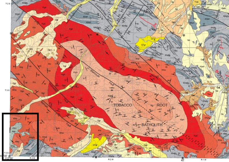
Geologic Map of part of the Tobacco Root Mountains. Reds and oranges are igneous rocks of the Tobacco Root Batholith, about 75 million years old. Grays are Precambrian rocks, about 1700 to 2500 million years old. Both maps from Vuke et al., 2014, Geologic Map of the Bozeman quad, Montana Bureau of Mines and Geology Open-file map 648. Black box in lower left corner is enlarged below. 
Oranges (Khto) are Tobacco Root Batholith, grays are Precambrian. X=Paleoproterozoic, about 1.7 to 1.9 billion years old; A = Archean, over 2.5 billion. XA means we aren't really sure. qfg = quartzofeldspathic gneiss, ah = amphibolite and hornblende gneiss. Xsp = Spuhler Peak formation. Branham lakes are blue. 
There isn’t much doubt that the metamorphic rocks there were originally mostly sedimentary rocks, sandstones, shales, siltstones, maybe even a few limestones, and that they were intruded by some igneous rocks like basalt, all before they were metamorphosed. We can infer what these protoliths, the original rocks, were, from the chemistry and mineralogy of the rocks today. So it’s a question that doesn’t matter too much, although it has big implications for the detailed story of this part of the world – when were sediments laid down, when were they metamorphosed. That in turn has implications for the structural and tectonic history, and understanding THAT helps us explore for mineral resources and understand things like earthquake fault distributions.

I’m not going to solve the question by walking up to the Branham Lakes. This beautiful location is about 9 miles or so up Mill Creek, east from Sheridan, Montana.

Most of the major valleys on the flanks of the mountains of southwest Montana held glaciers during the most recent glacial period that ended about 12,000 years ago or so.


Kyanite, Aluminum Silicate
Sediments like silts and muds usually contain plenty of silica, fine-grained quartz, but often they have fragments of feldspars or the clays that weather from feldspar, and those minerals contain a lot of aluminum. Under metamorphic conditions, high temperatures and pressures, the aluminum and other chemicals reorganize into minerals that are stable at those temperatures and pressures. There are three minerals, kyanite, andalusite, and sillimanite, which are chemically identical aluminum silicates, Al2SiO5, but which have different crystallography that reflects the details of the pressure-temperature regime in which the aluminum and silica were mobilized. Kyanite is stable at relatively low temperatures, 200 to 700°C, and low to high pressures; Andalusite forms at low pressures and medium temperatures, and Sillimanite forms at high temperatures across a range of pressures. The boundaries between these phases are well known so we can use their occurrence to infer the temperatures and pressures that the rocks reached during metamorphism.

Tobacco Root Batholith granite with dark xenolith of older rock
The Archean and early Proterozoic metamorphic events, about 2.5 billion to maybe 1.7 billion years ago, were ancient when the next potential metamorphic event took place, about 76 million years ago.

In the next clip, I made a mistake – I say epidote when I meant to say enstatite. They both start with an E, that’s my excuse! Enstatite is magnesium silicate, and hypersthene, also mentioned in the next clip, is enstatite with iron in it. Both are the kinds of minerals you can get by metamorphosing rocks that have a lot of iron and magnesium, probably NOT simple sediments like shale.

The road to the Branham Lakes, about 9 miles from Sheridan, Montana, is pretty good, and you could probably make it almost all the way in a 2-wheel-drive vehicle if you have decent clearance. I chose to leave my Prius about 2½ miles from the lakes just to be safe, as there are a few dicey stretches, and because it was such a fine day I really preferred to walk. If you go, it would be an unusual year that you’d find the road and lakes snow-free before late June at the earliest, but the setting is spectacular in July and August. I have a few photos from my walk on the blog, history of the earth calendar dot blogspot dot com.

I hope you have enjoyed this little ramble from the Precambrian to the Cretaceous to the glacial period of the Pleistocene. Thanks for listening!

Lower Branham Lake

—Richard I. Gibson

More photos on Facebook

Friday, January 16, 2015

The Precambrian - the daily episodes from 2014 combined


For 2014, the podcast consisted of daily productions averaging about 5 minutes each. The individual episodes for each month are now being assembled into packages for each month, representing various spans of time in the history of the earth.

This episode is the first package, which combines the 31 daily episodes for January, covering the Precambrian – the time from the origin of planet earth up to about 543 million years ago. This episode is an hour and 15 minutes long and includes all the individual daily episodes from January 2014.

If you listened to last year’s daily episodes, you’ll find that I’ve re-recorded some of them. Especially in early January, when I was just getting started, some of the episodes were technically lacking. I hope I have improved on that for this assembly of 31 episodes covering the Precambrian. Thanks very much for your interest in this project. As the year continues, there will be new episodes, maybe every week or two, in addition to these monthly assemblies.

If you have questions or comments, please let me know, either here on the blog – there’s a page for Question of the Week – or contact me by email at rigibson at earthlink.net. I’ll try to respond.
—Richard I. Gibson

Friday, January 31, 2014

January 31. The Ediacara – 560-600 million years ago


The Ediacara Hills of South Australia contain some remarkable fossils discovered in 1946, but largely ignored. They were thought to be of Cambrian age, and they were vague enough that it was challenging to determine what they were. With improvements in age dating, these fossils were eventually determined to be about 560 to 600 million years old – the Precambrian, a time when no one thought life existed, at least not as large animals.

Dickinsonia costata was as much as a meter across, or more.
They appear to be soft-bodied organisms, preserved as imprints in fine sand. There are disk-like shapes, and ovoids, with radiating textures. Some frond-like fossils have a quilted appearance, and there are many other varieties. We don’t know what they are.

Early interpretations suggested they might be jellyfish, or worms, or sea anemones. They have a wide range in size, from a few millimeters to more than a meter across. Some researchers say they aren’t animals at all, but are some kind of fungus. Or they might belong to a phylum, or even a kingdom, that has no modern representatives. 

Examples have been found in Newfoundland, England, Namibia, and elsewhere, so they appear to have been pretty common in the oceans that appeared after the glaciations and possible snowball earth ended 650 million years ago, perhaps 50 million years before the Ediacarans appeared. And interestingly, the Ediacaran life seems to disappear just before the Cambrian Explosion of life, about 530 million years ago.

Whatever the Ediacarans are, they represent an important step in the evolution of multicellular life on earth. Figuring out what they were, or what they are related to, is one of the ongoing challenges of geology and biology.

With the Ediacaran fossils, we reach the end of the Precambrian. The Precambrian represents 88% of Earth history, but we’ve compressed it into the month of January alone. The rest of the year will cover the most recent 500 million years of Earth history, because we know a lot more about it. And because it contains cool things like fossils and mountain ranges and sedimentary basins and coal swamps and dinosaurs. Tomorrow the Cambrian begins.
—Richard I. Gibson

UPDATE: Mary Droser (UC Riverside) and colleagues have described a new critter from the Ediacara. This weird one gets as big as 30 cm across and apparently grew as fan-like branches, flat on the sea floor or within the upper part of the sediment on the sea floor.


The Wikipedia article is a good overview, and has extensive links to scientific literature.

Photo by Verisimilius from Wikipedia under GNU Free Documentation license.

Thursday, January 30, 2014

January 30. Snowball Earth? 650-775 million years ago

By Richard I. Gibson

Here’s the podcast:


Snowball earth is the controversial idea that the Earth was entirely, or almost entirely, covered with ice and snow during three or four periods during the late Proterozoic, from about 650 to 775 million years ago. While there is abundant evidence that can be interpreted to suggest the existence of a snowball earth, much of that evidence can be interpreted in other ways as well.

The podcast outlines some of those lines of evidence. Below are some links for further reading.

http://www.snowballearth.org
http://en.wikipedia.org/wiki/Snowball_Earth
http://www.amazon.com/Snowball-Earth-Maverick-Scientist-Catastrophe/dp/1400051258
http://www.sciencedaily.com/releases/2011/10/111012083450.htm

Modern glacier photo by Dirk Beyer, under GNU free documentation license. 

Wednesday, January 29, 2014

January 29. Grenville Orogeny – a billion years ago

By Richard I. Gibson

Here’s the podcast:


Orange = Grenville rocks
In North America the primary mountain building event associated with the assembly of the Rodinia supercontinent was the Grenville Orogeny. It’s named for a village in Quebec where the mountain roots are exposed today, part of a wide belt in eastern Canada that extends into the United States in the Adirondacks of New York, and in the subsurface beneath central Ohio and Kentucky, where the Grenville Front is clearly marked in geophysical data. It continues southwest into West Texas and Mexico, and rocks that record the Grenville event are found in Scotland and South America too.

What was colliding with North America to make this mountain range? That’s still an area of active research, but we think several long linear belts – possibly complicated island arcs like Japan – as well as some small continental fragments impacted to help create the supercontinent of Rodinia. Some models show blocks that are now parts of South America and South Africa impinging on North America, but we really aren’t sure.

Grenville rocks in Canada are typically high-grade metamorphic rocks, indicating that there was plenty of heat and pressure involved in the collisions.

The compression that created the Grenville overlapped in time somewhat with the extension that was creating the Mid-Continent Rift that we talked about a few days ago. How can you have compression and extension at the same time? It’s not hard at all. Today, the Red Sea is forming by pull-apart on the west side of the Arabian Peninsula, while a thousand kilometers away, on the east side of Arabia, active continent-continent collision is causing the earthquakes of Iran.

Further reading: see the links and references in the Wikipedia article.

Map by G. Mills (public domain) after Tollo and others, 2004, Petrologic and geochronologic evolution of the Grenville orogen, northern Blue Ridge province, Virginia, in Proterozoic tectonic evolution of the Grenville orogen in North America, Geological Society of America Memoir 197.

Tuesday, January 28, 2014

January 28. The Supercontinent of Rodinia


By Richard I. Gibson

Here’s the podcast:


Transcript:
It seems like only a few days ago that we were talking about the break-up of the supercontinent called Columbia. Now we’re assembling another one, called Rodinia. Well, yes – but in those few days, 400 million years have passed since the Belt Basin began to form on January 24, 1.4 billion years ago. 400 million years is enough time for continents to rift apart and come back together. They were coming together again about 1 billion years ago.

Map from US Antarctic Program (public domain).
Red dots are granite bodies.
Rodinia is a Russian word meaning the motherland. It’s fair to think of Rodinia as a more or less conglomeration of continental masses, but it’s probably wrong to visualize a concerted assembly followed by a synchronized separation.   Just as today, there were probably some pieces coming together while others were drifting apart. But Rodinia does represent a large landmass that contained at least a good number of the continental blocks, for maybe as much as 200 million years.

We really don’t know the details of Rodinia’s configuration all that well. The map in the blog shows one version, but there are plenty of alternatives. While it was one big land mass, it might have served as an insulating blanket over the hot interior of the earth, so that granites pooled along the base of the continental crust and intruded it in places – at least, there are a lot of granite bodies of this age that don’t seem to be related to mountain building. They might represent something like that.

However it was assembled, it began to break apart by about 750 million years ago, and maybe as early as 800 million years ago. The break up of Rodinia may have impacted both the climate and the evolution of life on earth. We’ll discuss those impacts in a few days as the Proterozoic comes to an end.

On January 28, 1902, William C. Krumbein was born in Beaver Falls, Pennsylvania. He was an innovative geologist, and co-author of the traditional textbook on sedimentation and stratigraphy that was used in many college courses from the 1960s to the 1980s.

Further reading:

http://en.wikipedia.org/wiki/Rodinia
http://io9.com/5744636/a-geological-history-of-supercontinents-on-planet-earth
http://www.peripatus.gen.nz/paleontology/Rodinia.html

Monday, January 27, 2014

January 27. Keweenaw Copper


By Richard I. Gibson

Listen to the podcast:


Transcript:
Keweenaw copper district
The mid continent rift system ruptured the crust of Proterozoic North America, allowing magmas to flow into parts of the rift. But don’t think of it as a simple low-lying trough: the flanks of the trough were probably fairly high mountains, and basins bordered the trough and mountains. Lots of sediment came into those basins.

Coarse sediments, deposited relatively close to the mountains, included pebbles and cobbles that solidified into a rock called conglomerate, nicely exposed in the area around Copper Harbor, on Michigan’s Keweenaw Peninsula. In some places, the cement holding those pebbles together has been replaced by pure native copper that was brought to the surface by the volcanism associated with the mid-continent rifting about 1.1 billion years ago.

On average, only about 1½% of the rock is copper, but it still adds up to one of the greatest copper deposits on earth. And unlike most of the world’s copper mines today, which are copper sulfides, the Keweenaw copper is pure – already in metallic form, called native copper. Relatively easy to mine, and because of the lack of sulfur, environmental problems are much less serious than in copper sulfide mines where sulfur generates sulfuric acid and pollution that can be challenging to deal with.

Native copper
The first copper rush to northern Michigan was in 1843-1846, and by about 1870, 95% of America’s copper came from this area. But after decades of mining, the area was surpassed by western mines in Butte, Montana, and in Utah and Arizona in the late 19th century. The copper industry in Michigan was pretty much dead by the 1970s, but relatively high copper prices mean that there are several projects in the works today to rejuvenate copper mining there.

Photo by Jonathan Zander under GNU free documentation license.


Map from Michigan Tech

Useful links for further reading:
http://www.nps.gov/history/history/online_books/geology/publications/pp/754-b/sec1.htm
http://pubs.usgs.gov/of/1999/of99-149/
http://www.geo.mtu.edu/~raman/SilverI/BlackLavas/Stratigraphy/Stratigraphy.html
http://www.geo.mtu.edu/~raman/SilverI/BlackLavas/Copper_Mining.html

Sunday, January 26, 2014

January 26. The Mid-Continent Rift


By Richard I. Gibson

Here is the podcast:


Green is the area where there is basalt in the subsurface, more or less.
Transcript:
I think most Americans have a sense of what Iowa is like today – relatively flat, low hills, scenic river valleys, thick fertile soils supporting lots of farmland. A billion years ago it was quite a different place. More like East Africa, minus the plants and animals. A billion years ago, North America was trying to split apart, just as East Africa is today.

The split, called the mid-continent rift system, extends from central Oklahoma through eastern Kansas, then diagonally across Iowa, along the Wisconsin-Minnesota border and into Lake Superior. It swings around to head south beneath the lower peninsula of Michigan before it ends around Detroit.

Visualize fissures spewing basalt magma along most of that zone for 15 to 20 million years. Like Iceland’s volcanoes, filling a trough as much as 40 miles wide and more than a thousand miles long with basalt lava flows. The piles of lava flows added up to 2 to 10 miles of basalt and other volcanic rocks.

This rift was a zone like the mid-Atlantic ridge where heat moving up from the earth’s mantle splits the crust. The best modern analog for the mid continent rift system is East Africa, the Red Sea, and the Gulf of Aden – three branches that form what’s called a triple junction. The third arm of the system in North America headed north from Lake Superior beneath lake Nipigon in Ontario.


Magnetic map of Iowa
The mid-continent rift system failed, for reasons that are not completely clear, but we’ll talk about one possible factor in a couple days. So it never reached the stage of true ocean crust, like the Red Sea, but was always like the complex system of troughs, mountain chains, and volcanoes that mark the East African rift today.

Gravity map of Iowa
How do we know it’s down there? The best evidence comes from remote sensing – measurements of the earth’s gravity and magnetic fields. Those basalts in the trough are very dense and very magnetic compared to other rocks, so they produce a dramatic signature in gravity and magnetic maps.

The maps of Iowa show a long curving band of gravity and magnetic highs extending from near the southwest corner of the state to the northern boundary with Minnesota. And further north, along the continuation of the zone, the rocks actually crop out on the surface around Duluth Minnesota, and on Lake Superior’s Isle Royale and the Keweenaw Peninsula of Michigan.

This all happened over a geologically short period, 20 million years or so, about 1.1 billion years ago. The consequences are still evident today, in the presence of Lake Superior in the basin that sits on the rift, and in the mineral resources created by the volcanism. We’ll talk about that tomorrow.

There are a lot of good online resources about the mid-continent rift, so be sure to check the links below for more information. 

http://en.wikipedia.org/wiki/Midcontinent_Rift_System
http://crustal.usgs.gov/projects/midcontinent-rift-minerals/index.html
http://www.nature.com/news/geology-north-america-s-broken-heart-1.14281
http://www.gravmag.com/gmprimer.shtml
http://www.igsb.uiowa.edu/browse/rift/mrs.htm

All maps from USGS.

Saturday, January 25, 2014

January 25. Oldest Megascopic algae

By Richard I. Gibson

Here is the podcast:


Grypania spiralis
When I wrote the book back in 1994, the oldest eukaryote organisms – single-celled creatures with a distinct nucleus – were thought to be algae from the Beck Spring Dolomite of Eastern California. They are about 1.3 billion years old, and some of those algal cells were large enough to be megascopic - seen with the naked eye.

In 2004 S. Sarangi and colleagues at the National Geophysical research Institute in Hyderabad India reported an age of 1.6 billion years for the megascopic alga Grypania spiralis. Some dates from Michigan have suggested that Grypania is as old as 2.1 billion years.

Understanding the timing and worldwide extent of things like megascopic algae has implications for understanding the evolution of the atmosphere and its oxygen content. Scientists who work on these problems try to correlate the timing of global algal blooms with evidence of oxidation in banded iron formations to get at the timing of changes in atmospheric oxygen.

Photo by Xvazquez, via Wikipedia under GNU free documentation license. 

Friday, January 24, 2014

January 24. Belt Basin 1.3-1.4 billion years ago

By Richard I. Gibson

Here’s the podcast:


Transcript:
St. Mary Lake, Glacier National Park. Photo by David Restivo, NPS
We’ve talked briefly about continental crustal fragments large and small drifting around the earth’s surface, a process which continues today. Inevitably, at some times a lot of the continents might come together to create what we’ve come to call a supercontinent. While we won’t encounter the best known supercontinent, Pangea, until August, supercontinent assemblies have happened repeatedly in the past.

The Sioux Quartzite was deposited in North America during the time that the supercontinent called Columbia is thought to have existed, around 1.7 to 1.5 billion years ago. We know something more about the break up of that possible supercontinent than its assembly, and there is abundant evidence for a break, separating what is now western North America and eastern Siberia, around 1.4 billion years ago.

That break created a huge basin in what is now the northwestern United States and nearby parts of Canada. It was filled with as much as 50,000 feet of mostly fine-grained sediments, mostly mud and silt that lithified into shale, mudstone, and a few sandstones and limestones. We call this thick package of rocks the Belt Supergroup, named for occurrences in the Big and Little Belt Mountains of Montana.

Armored mud balls in Grinnell Formation,
Glacier Park. Photo by Richard Gibson.
The Belt rocks are beautifully exposed in Glacier and Waterton National Parks, where they display red and green colors sculpted by glaciers that were vastly younger than the rocks themselves. The rocks contain details that give us lots of information about the early earth. For example, thin layers of coarse grains indicate that storms probably stirred up the sediment on the floor of a shallow lake or sea. It may seem obvious that rain fell on the ancient earth, but we KNOW it did because of raindrop impressions found in some of the Belt rocks.

One of the most remarkable things about the Belt rocks is the immense span of time that they represent – maybe as much as 250,000,000 years of relatively undisturbed deposition. Understanding the Belt is challenging, to say the least, and has been the life work of many geoscientists.

From Idaho State University
Lots of geologists try to figure out how the earth’s early continents were combined before they broke up – this has implications for resource exploration as well as pure science – and a lot of effort went into the question of what continent separated from western North America to create the Belt Basin. Antarctica, Australia, and Siberia were popular candidates. But thanks especially to the work of Jim Sears and his students at the University of Montana, and Paul Link at Idaho State, I think it’s pretty well settled now that it was Siberia that was once where western Washington and Oregon are today. UPDATE March 2014: maybe not ... some recent work suggests that it might NOT have been Siberia out there... stay tuned - I'll add information soon.

Thursday, January 23, 2014

January 23. Sioux Quartzite 1.7-1.6 billion years ago

By Richard I. Gibson

Here’s the podcast:


Transcript:
Sioux quartzite
After the Trans-Hudson and Penokean mountain building episodes, which we talked about a few days ago, weathering attacked the mountains and eroded them. After about 150,000,000 years, much of what is now the southern edge of the Superior Craton was a low-lying, subsiding area crossed by braided streams. These rivers flowed between about 1.76 billion and 1.63 billion years ago

The streams carried quartz grains, sand, that created a deposit as much as 3,000 meters thick in what is now Minnesota, South Dakota, Iowa, and Nebraska. That’s nearly two miles of Proterozoic sandstone, so intensely cemented and lithified that it’s called quartzite. The package is called the Sioux Quartzite, and Sioux Falls drops over a resistant escarpment in this rock.

Similar rocks are found on the surface around Baraboo, Wisconsin, as well as in Arizona and New Mexico. It’s likely that much of North America was a low shield being eroded by shallow streams around 1.7 billion years ago. The countryside around those rivers would have been bleak by modern standards – no life at all, no trees, no grass, no plants, no animals. Not even any soil as we would recognize it, since modern soil contains a lot of organic matter. Just loose rocks and grains of resistant quartz.

The Sioux Quartzite is so thick and resistant that the area where it crops out has been a persistent relatively high area for much of earth history. Any sediments that were laid down across it during high stands of seas have been stripped off so that today Sioux Falls and the surrounding area are a window into the past.

The Sioux Quartzite is a pretty, pinkish rock that has been used in many historical buildings in the city of Sioux Falls and surrounding areas.

Geologic map of China showing location of 1556 quake.
Today, January 23, is also the anniversary of the most deadly earthquake in human history. In 1556, in Shaanxi, north central China, a quake estimated at a 7.9 magnitude killed at least 830,000 people. 7.9 isn’t that intense, as quakes go, but at the time many of the people there were living in caves dug into soft earth, and many died in the collapse of those caves.

The quake was ultimately a result of the interaction of India and Eurasia. The geologic map shows the area around Xian to be near the intersections of several major faults, which were strained and continue to be strained by the northward push of India even though its collision was hundreds of kilometers to the southwest.

Quartzite photo by Andrew Wickert, via Wikipedia under Creative Commons license.

Wednesday, January 22, 2014

January 22. Gneiss

By Richard I. Gibson

Here’s the podcast:


Gneiss, pronounced "nice," is from a German word that means spark and it’s a metamorphic rock that has been heated and pressurized so much that the chemicals have been rearranged to form minerals in distinct bands, often alternating light and dark minerals.

Four pieces of gneiss
Metamorphism means “changed form” and that can happen to any rock, from granite or basalt to sandstone and limestone. Granite is pretty common in the continental crust of the earth, so granites from the Precambrian are often metamorphosed into granite gneiss, but the original rock could be almost anything, as long as the chemistry is right.

Because Precambrian rocks have been around so long, it’s no surprise that they may have been metamorphosed repeatedly. The layers that you see on the side of a piece of gneiss are not depositional beds like you would find in sandstone or shale, but they were formed with that preferred orientation under high heat and pressure. These surfaces are called foliation to distinguish them from sedimentary bedding.

There are as many kinds of gneiss as you want – geologists use modifiers to provide more information, so it might be a garnet gneiss, or a quartzo-feldspathic gneiss, or an amphibolite gneiss, granite gneiss, or a dozen other names. They just tell you some of the dominant minerals in the rock, or maybe something about its likely origin.

The other common type of metamorphic rock is schist, which generally has more mica in it than gneiss. We’ll talk about that another day.

Tuesday, January 21, 2014

January 21. Trans-Hudson and Penokean Orogenies

By Richard I. Gibson

Listen to the podcast:


Transcript:

About 1.85 billion years ago, as the last of the banded iron formations were being deposited, the core of North America, the Superior Craton, was growing. The smaller Wyoming Craton and other nearby blocks collided with the Superior Craton, raising up a mountain range, possibly of Himalayan proportions, in the area we know today as Saskatchewan, Manitoba, North and South Dakota, and western Nebraska.

This collision was much like India’s ongoing collision with Asia, so the idea that the mountains there were like the Himalayas is not out of line. A few hundred million years of erosion, and there’s nothing left of that mountain range, but there is plenty of subsurface evidence for it expressed in measurements of the magnetic and density properties of the rocks that were once the mountain roots. The zone was a persistent weakness in the earth’s crust, and by Ordovician time (which we’ll talk about in March) this area sagged to form a sedimentary depression, the Williston Basin, important today as the host for oil deposits including those of the Bakken Formation, which we'll talk about in May.

Another small rigid block collided with what is today the southern edge of the Superior Craton, in northern Lake Michigan, across Wisconsin and Minnesota and into present-day Iowa. This zone is called the Penokean Fold Belt. It’s probably no accident that those wonderful banded iron formations were along the edge of this zone—they were probably laid down in a deep marine setting, a trench between the two continental blocks that ultimately fused to make the North American craton a bit bigger.

Monday, January 20, 2014

January 20. Banded Iron Formation: 1.8 billion years ago


By Richard I. Gibson

Here's the podcast:


Transcript:
Yesterday we touched on the role of iron in holding off the growing oxygen crisis for some hundreds of millions of years. By about 1.8 billion years ago, the last of the abundant reactive iron in the oceans had combined with oxygen to form iron-rich rocks known as banded iron formations. There are some younger examples, but by far most of the banded iron formations on earth are older than 1.8 billion years.

These rocks are excellent ore bodies, and the Mesabi Iron Ranges of northern Minnesota are great examples. They continue into northern Wisconsin and upper Michigan, and they supply about 97% of the iron ore produced in the United States, worth about $6 billion in 2013. That’s enough to make the U.S. a net exporter of iron. Western Australia’s Pilbara region contains similar iron ores of similar age, and other banded iron formations are found around the world. Iron was clearly precipitating out of the oceans all over the place.

The bands are alternating layers of hematite and magnetite, two iron oxide minerals, plus silica in the form of cryptocrystalline chert. A lot of this chert is jasper, colored red by iron. Banded iron formations are pretty rocks.

On this day, January 20, in 1875, Geologist Charles Kenneth Leith was born in La Crosse, Wisconsin. He was the head of the geology department at the University of Wisconsin for 31 years, and his specialty was the iron-bearing rocks of the Lake Superior region. 

Photo by André Karwath, from Wikipedia, licensed under the Creative Commons Attribution-Share Alike 2.5 Generic license.

Read more:  James St. John’s page • Genetic modeling banded iron formation

Sunday, January 19, 2014

January 19. The Oxygen Crisis. 2 billion years ago.


By Richard I. Gibson


We know there was some free oxygen in the atmosphere by 2.3 or 2.4 billion years ago, but it took until around 2 billion years ago, after 700,000,000 years of work by the cyanobacteria, for there to be enough oxygen in the atmosphere to think of it as relatively oxygen rich.

For a while, a few hundred million years, the highly reactive oxygen given off by photosynthetic organisms probably combined with iron dissolved in the early oceans, so oxygen didn’t accumulate in the atmosphere. It produced thick iron oxide deposits like those in Minnesota, which we’ll talk more about tomorrow.

Was the air breathable, if we went back in a time machine 2 billon years? No one knows for sure—there is no good way to reliably estimate the percentage of oxygen in the early atmosphere. But probably not. The concentration of oxygen may not have been great enough for another billion years or more for oxygen dependent animals to evolve, but it did happen eventually. Obviously!

What was a boon for oxygen-based life was a crisis for the original anaerobic life that didn’t need oxygen. Today such life is limited to a few small niches such as the reducing environments in swamps and deep oceans and near volcanic vents. Free oxygen is poisonous to the bacteria that got things started for life on earth, but the crisis for them probably was the impetus that allowed for multicellular plants and animals to develop toward the end of the Proterozoic era.

Update, September 2014. In the episode above we talked about the origin of atmospheric oxygen, a development tied to the expansion of oxygen-excreting, photosynthesizing cyanobacteria. The point at which oxygen began to become plentiful in the atmosphere has been pegged at about 2.96 billion years ago, with levels becoming noticeably high by about 2.4 billion years ago or later. A new study by researchers at Trinity College Dublin, Ireland, and the Presidency University in Kolkata, India, pushes the onset of oxygenation back about 60 million years, to about 3.02 billion years ago. Here’s a link to a report on that research.


Atmosphere photo from NASA (public domain).

Saturday, January 18, 2014

January 18. Gunflint Chert

By Richard I. Gibson

Listen to the podcast:


Click to enlarge

Transcript:
When I was in college, the Gunflint Chert was a hot topic because back then it was the first assemblage of microfossils ever found in the Precambrian, and that discovery had just been reported in 1965. And the fact it was from Minnesota and Ontario helped, since I was learning geology in nearby Michigan and Indiana. The discovery of real fossils in rocks so old that no one thought fossils were possible was a big deal, and it touched off intense interest in early life that continues to this day.

The chert, a microcrystalline form of silica, is usually black or sometimes red. Red chert is called jasper. It holds tiny spheres, rods, and filaments that most likely represent the cyanobacteria that made stromatolite mats. It’s possible that the fossils may include some algae and fungi as well.

Stanley Tyler at the University of Wisconsin discovered and worked on these fossils beginning in 1954, and working with and Elso Barghoorn at Harvard published a report in 1965 calling them the oldest fossils ever seen. One organism, Eosphaera tyleri, named for Tyler, is a near-perfect sphere about 20 micrometers across – that’s just two hundredths of a millimeter. It may have been a floating bacterium or alga. It would take 100 of them to reach across a typical grain of sand. Image above or at right from J. W. Schopf, 2000, Proceedings of the National Academy of Sciences (PNAS), 97:6947-6953. This image is made available for teaching purposes by PNAS and I am using it on that basis. It is a copyrighted image, ©PNAS. 10 micrometers (μm) is one-one hundredth of a millimeter.

So how old are they? In 2002, Philip Fralick and colleagues, at Ontario’s Lakehead University and the Royal Ontario Museum reported a well-constrained age date for the Gunflint flora of 1 billion 878 million years, plus or minus 1.3 million, based on uranium-lead radioactive dating. That’s really very accurate, and has become accepted as the age of these fossils. We have older fossils now, but it was the Gunflint Chert that touched off the scientific gold rush to seek older and older microscopic life on earth.

The Gunflint Chert is part of a package of rocks called banded iron formation that we’ll talk more about in a couple days.


Photomicrograph at left of thin section from the Gunflint Chert. The clear areas are chert; yellowish are siderite (iron carbonate), and black is iron oxide, probably magnetite. The largest crystal, labeled M, is about ¼ millimeter across. It would take about 250 individual Eosphaeras to span this crystal. (From R.D. Irving and C.R. Van Hise, 1890, The Penokee iron-bearing series of Michigan and Wisconsin: USGS Tenth Annual Report.)


Further reading:
Source of Schopf image
The age dating
More about Stanley Tyler

Friday, January 17, 2014

January 17. Australian and Antarctic Cratons


By Richard I. Gibson

Much of Western Australia is underlain by Archean or early Proterozoic rocks in two major cratons, the Yilgarn and Pilbara Blocks. It’s likely that these blocks extend in the subsurface into central Australia, but most of Eastern Australia is much younger in terms of the age of formation of the basement rocks there.

Original map by Rolinator, via Wikipedia under GNU free documentation license.

Here is the podcast:


January 16. South American Cratons


By Richard I. Gibson

The cratonic core of South America is the Brazilian Shield, composed of Archean rocks modified by later tectonic events. The similar but smaller Guyana Shield occupies the northern part of the continent.

The two cratons are separated by the Amazon Rift – a long-standing break in what was probably originally a single large craton. That break follows a weak zone that has been around for hundreds of millions of years, and is the reason the Amazon River is where it is.

Map derived from U.S. Geological Survey

Here's the podcast:

January 15. The Baltic Shield


By Richard I. Gibson

The stable core of Europe is called the Baltic Shield because the Archean rocks that make it up are exposed over much of the Scandinavian Peninsula, Finland, and the area around the Baltic Sea. Like most cratons that are partly covered by younger rocks, the Baltic Shield continues much further in the subsurface. It underlies most of European Russia, where it is called the East European or Russian Platform. Bits of it reach the surface again in Ukraine, in two small areas called the Ukrainian Shield and the Voronezh Arch.

Map derived from U.S. Geological Survey.

Listen to the podcast:

Thursday, January 16, 2014

January 14. Africa’s Architecture


By Richard I. Gibson

Much of the Transvaal or Cape Craton, in South Africa, is exposed at the earth’s surface. This is one reason that the oldest examples of earth rocks come from this area, and why South Africa is so rich in the kinds of dense elements that were concentrated in the early earth, like diamonds, platinum and palladium.

Map of some of Africa's cratons modified from U.S. Geological Survey. 

Here is the podcast: