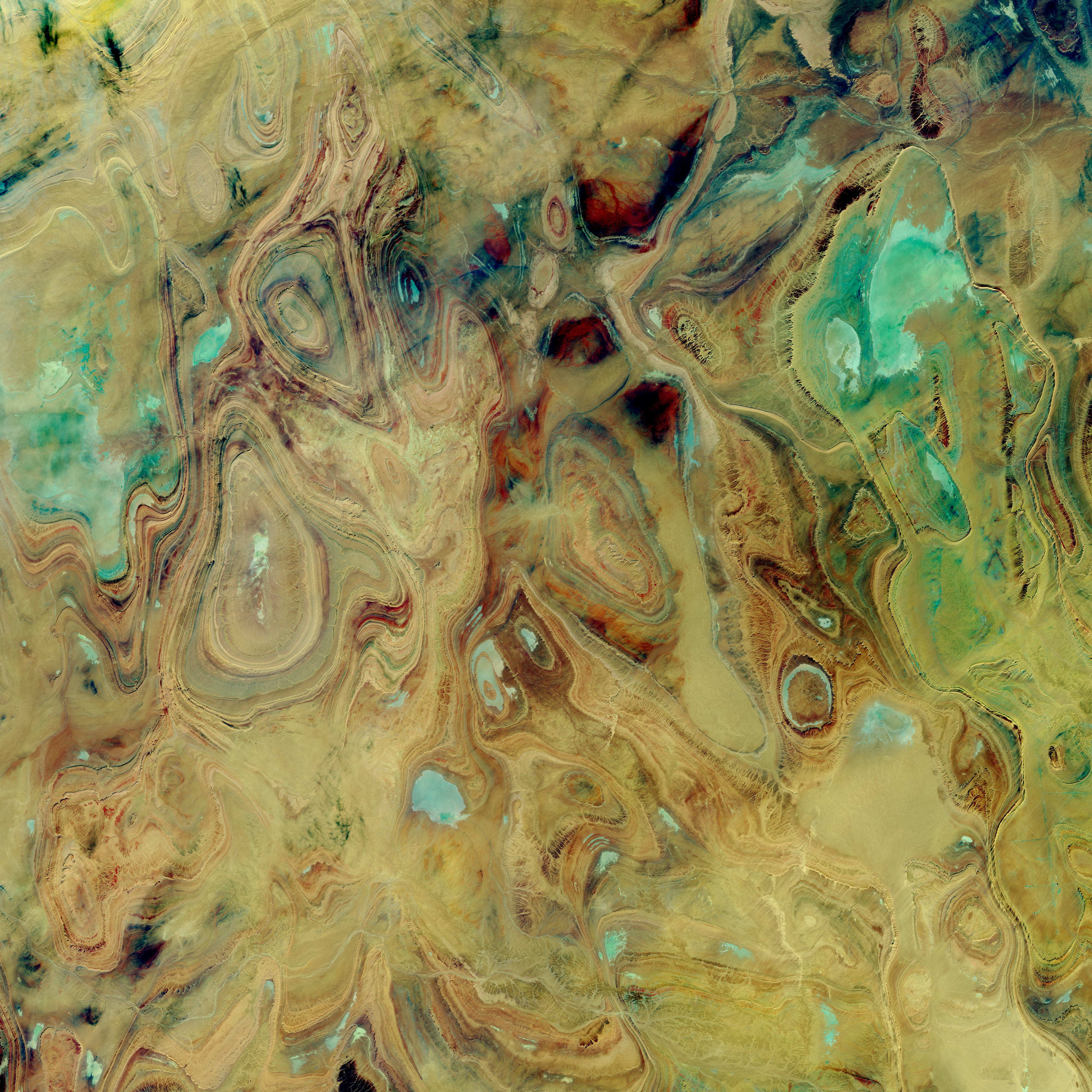
You may have seen some of the spectacular images of the
earth in southern Algeria, curves and colors like some Picasso in the opposite
of his cubist period. If you haven’t, check out the one from NASA, below.
The ovals and swirls, with their concentric bands, are
immediately obvious to a geologist as patterns of folds, but not just linear
folds like many anticlines and synclines form. These closed ovals represent
domes and basins – imagine a large scale warping, both up and down, in a thick
succession of diverse sedimentary rocks, like sets of nested bowls, some of
them right-side up and some inverted, then all sliced off halfway through.
But “obvious to a geologist” has plenty of limitations in a
space image. Without knowing more information, it’s difficult to be sure if an
oval is a basin or a dome. And you can speculate, but without some ground
truth, it’s challenging to be sure what the rock types are.
This area, called the Ahnet-Mouydir, on the flank of the Hoggar Mountains close to the middle of the Sahara Desert, is remote, inhospitable, and arid, and called the “land of terror” for a reason. The rocks represent a thick sequence of marine sandstones, shales, and limestones, spanning a huge range of ages, from at least the Ordovician to the early Carboniferous – 150 million years or more, a great chunk of the Paleozoic era.
 |
| Ahnet-Mouydir, Hoggar Mountains, Algeria. NASA image - source |
This area, called the Ahnet-Mouydir, on the flank of the Hoggar Mountains close to the middle of the Sahara Desert, is remote, inhospitable, and arid, and called the “land of terror” for a reason. The rocks represent a thick sequence of marine sandstones, shales, and limestones, spanning a huge range of ages, from at least the Ordovician to the early Carboniferous – 150 million years or more, a great chunk of the Paleozoic era.
The core of the Hoggar Mountains is an old Precambrian
block, not as big as the cratons and shields that form the hearts of most of
the continents, but otherwise similar. It might have been something like a
microcontinent that became amalgamated into the growing supercontinent of
Gondwana about 600 million years ago. After that amalgamation, seas came and
went much like they did in western North America throughout much of the
Paleozoic era, laying down the sediments that became the rocks we see today in
the northern Hoggar Mountains.
That’s all well and good – but here’s the next question, how
did the rocks get deformed into these oval domes and basins? If you imagine the
kinds of collisions that are typical on earth, you think of linear or
curvilinear things – island arcs, edges of continents and such – that when they
collide, are likely to make linear belts of deformation. This is why so many
mountain ranges are long, linear features, and the folds and faults that make
them up also tend to be linear. Domes and basins happen, but that seems to be
almost all we have here in these mountains.
We have to look for a deformational event that is later than
the youngest rocks deformed. So if some of these rocks are as young as early
Carboniferous, about 340 million years old, the mountain-building event that
fills the bill is the Hercynian Orogeny, where ‘orogeny’ just means
mountain-building.
The Hercynian, at about 350 to 280 million years ago,
represents the complex collision between Gondwana and the combined North
America and Europe, which were already more or less attached to each other. The
leading edge of Gondwana that collided was in what is now North and West
Africa, and the collision produced mountain ranges all over – the Alleghenies
in the central Appalachians in North America, and a complex swath of mountains
across central Europe, from Spain, across France to northern Germany and into
Poland, as well as elsewhere. In Africa, the most intense squeezing was at the
leading edge, in what is now Morocco and Mauritania, colliding with North
America, and northern Algeria, impacting Iberia.
The basins and domes of southern Algeria that we’re trying
to understand are 1500 kilometers or more from that leading edge of continental
collision. So I think – and full disclosure, I’ve never really researched this
area in detail – that what must have happened is that that distant hinterland
wasn’t pushed into tight, linear belts like those we find along the lines of
collision, but the force was enough to warp the sediments into these relatively
small domes and basins. Alternatively, it might be possible that the brittle
Precambrian rocks beneath the sedimentary layers broke from the force of the
collision, so that the sedimentary layers draped over the deeper brittle
surface like a carpet lying over a jumble of toy building blocks – some high,
some low.
The latter idea, that the brittle basement rocks were broken
and pushed upward with the sedimentary layers draped over them is supported by
research published in the journal Terra Nova in 2001. Hamid Haddoum and
colleagues studied the orientations of folds and faults in this area, trying to
figure out the orientations of the stresses that caused them. Their data show a
shortening direction – which means compression, or squeezing – during early
Permian time oriented about northeast-southwest. That is consistent with the
collision that was happening at that same time between what is now Senegal and
Mauritania, in westernmost Africa, and the Virginia-Carolinas region of what is
now the United States. Haddoum and his colleagues show cross-sections with
basement upthrusts, basically high-angle reverse faults where older rocks are
squeezed so much that they are pushed up and over younger rocks. This is quite
similar to the Laramide Orogeny in the western United States about 80 to 50
million years ago, but this compression was happening about 280 million years
ago as the supercontinent of Pangaea was assembled during the early Permian
Period. Both represent deformation at relatively great distances from the lines
of continental collision. In the case of the Laramide in western United States,
one idea for transmitting the stress so far from the collision is that the
subducting slab of oceanic crust began to go down at a relatively gentle angle,
even close to horizontal, creating friction and stress further away from the
subduction zone than normal. Whether that’s the case here in southern Algeria
isn’t clear for this Hercynian collision.
I wouldn’t think of this area as high mountains, such as
those that must have formed along the lines of Hercynian collision. Maybe more
like warped, uplifted plateaus – but whatever they were, they were certainly
subject to erosion. Erosion probably wore the domes and basins down to a common
level, so that the nested bowls were exposed in horizontal cross-section –
which for geologists is the equivalent of a geologic map. And that’s what the
beautiful photos reveal.
The area might have been planed off even more by Permian glaciers
during and after the Hercynian mountain-building events. But then, during the
Mesozoic era, seas returned to the region and all this mess of eroded domes and
basins was buried beneath even more sediments. Sometime relatively recently,
during the Cenozoic era, the past 65 million years, everything was uplifted at
least gently, so that the highest parts – including today’s Hoggar Mountains,
were stripped of the younger Mesozoic sedimentary rocks, revealing the much
older Paleozoic rocks in the domes and basins.
—Richard I. Gibson
Link: