Geology

Geology
The 366 daily episodes in 2014 were chronological snapshots of earth history, beginning with the Precambrian in January and on to the Cenozoic in December. You can find them all in the index in the right sidebar. In 2015, the daily episodes for each month were assembled into monthly packages (link in index at right), and a few new episodes were posted from 2015-18. You may be interested in a continuation of this blog on Substack at this location. Thanks for your interest!

Wednesday, December 31, 2014

December 31. The 6th Extinction


So we’ve made it to the end of our geological year, covering 4.6 billion years of geologic time. 366 episodes, close to 180,000 words and a total of about 25 or 30 hours of programs. I hope you’ve enjoyed it! The podcast will not end, but the structure will change as we go into next year. It won’t be daily any more, sorry to say – there were times when it was really touch and go in terms of me getting the episodes out, but I’m happy to say I managed. Thanks for your interest – that was my main motivation once things got going. 

I’m not certain exactly what sorts of topics next year will bring. I’m not going to try to cover “current events” in any particular way because there are many good blogs and podcasts that do that. I expect I may do a few more that use my own work as a basis, and some posts will probably be based on topics in my other book, What Things Are Made Of. I want to try to do a few interviews with geoscientists working on interesting topics, and that may give it a Montana-centric flavor, but we’ll try to make things pertinent to a wide audience. Since I only covered 366 topics – and they were selected largely based on my own prejudices – there’s certainly plenty more that we can look at. Feel free to submit questions or suggestions, either through the blog or email me at rigibson at earthlink.net. You’ll get a spamblocker message, but I’ll find your email. I’m not going to make any promises, but I am going to shoot for at least one episode every week or ten days next year. 

I also will be assembling the existing podcasts into single recordings. I’m not sure how it will work in terms of file sizes, but I’m hoping that I can make each month of the previous series into one or two packages – without the repetition of the intro music and exit tagline. I’ll try to edit the episodes into those assemblies early in the coming year and make them available in the usual way, through the blog. 

To close the year, I thought I might address what has been called the Sixth Extinction. Of all the mass extinctions in earth history, only five have been really, really devastating. Those are the ones at the end of the Ordovician, in the Late Devonian, the biggest of all at the end of the Permian, the Triassic-Jurassic extinction, and the one that ended the Cretaceous Period and the Mesozoic Era. The case has been made that we are presently in the midst of another mass extinction, the Sixth great one.

There is an entire book, titled The Sixth Extinction: An Unnatural History, by Elizabeth Kolbert. It just came out in 2014, and I recommend it highly. The New York Times Book Review listed it as one of the ten best books of 2014. The book makes the case for a present-day massive die-off of organisms, ranging from bugs and bats to corals and rhinos. We’ve seen in the podcasts in this series that things like climate change certainly affect extinction rates, and there is no question that earth’s climate is changing at high rates right now. There’s also no question that human activities are affecting many of the things that contribute to climate change. It’s happening.

Kolbert integrates our knowledge of past extinctions, such as the disappearance of the ammonites, which you have heard about in this podcast series, as lessons for the present.

We don’t really know how many species of plants and animals exist on earth today, although we have good ball-park estimates. New species, even new large animals, are being found all the time. So it’s hard to say with certainty what kind of extinction rate is in progress, but some estimates say that as far as we can tell, extinction rates today are as much as 1,000 times those that typified most of earth’s history. We might argue about whether what’s happening now is on a scale comparable to the Big Five Extinctions, but at some scale, an extinction event is assuredly in progress.

The big, charismatic animals, like rhinos, elephants, tigers, and whales, that need extensive spaces for their lifestyles, are probably most threatened by human pollution and invasion of habitat, but who knows what’s going on in the insect world or the frog world? Those who study frogs are concerned. Is it possible to help all, or even most, species survive in a human-dominated world? I certainly don’t know. Should we even try? From both the altruistic and selfish points of view, it would probably be advantageous to try. Even human-centric people can’t deny the continual discoveries of beneficial products that come from obscure plants and animals.

For me as a geologist, I sometimes take the long view – the earth does not care. If humans kill off lots of things, including perhaps themselves, earth, and life, will continue. It always has, and until the sun burns out or some incredible catastrophe happens, it always will.

Thanks for joining me on this journey. If you’ve learned a tenth of what I have learned in putting these talks together, you’ve learned a lot! I hope it was fun!

—Richard I. Gibson

LINKS:
Extinction rates

Animals that went extinct in 2014

Tuesday, December 30, 2014

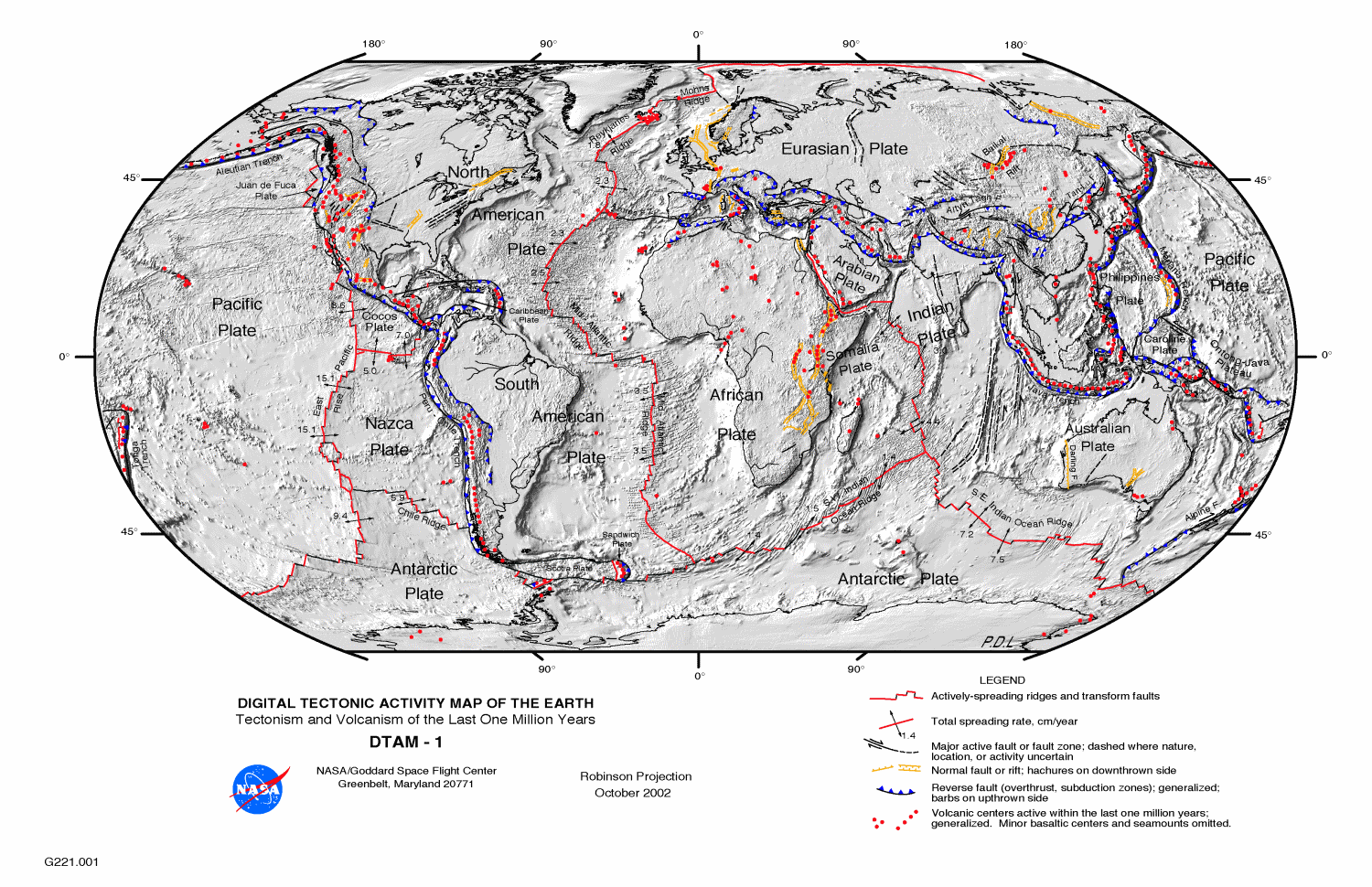
December 30. Modern Plate Tectonics


Through the year, we’ve talked about events that broke apart and combined the various tectonic plates on the earth, but today, as we’ve almost reached the present, I wanted to just summarize the way things are today. 


First, I know I talked repeatedly about oceanic crust and continental crust. They are quite different from each other, in density, thickness, and mechanical behavior, and those differences drive subduction and plate tectonics. But the two types of crust also move together, a lot. The North American Plate includes all of the North American continent – except the bit of California west of the San Andreas Fault – but it also includes the oceanic crust beneath the North Atlantic Ocean, all the way out to the Mid-Atlantic Ridge. Iceland straddles the mid-ocean ridge, a pile of volcanic material erupted because of a hotspot at depth, but the west half of Iceland is part of the North American Plate, and the east half is on the Eurasian Plate.  

Depending on exactly how you want to define “major,” there are 9 to 16 major plates. Africa has two sub-plates – Arabia, which is tectonically separated from Africa, but only by the width of the young Red Sea, and the Somalia Plate, breaking away along the East African Rift. The Somalia Plate is certainly separating from Africa, but in many ways and in many places, they’re still attached to each other too.

Then there’s the North American and South American Plates, both of which include the continent and the western half of the Atlantic Ocean. There is only a vague boundary between the North and South American Plates, because they are to a large extent moving together at a similar speed and direction. There is an extensional rift between North America and Greenland – but it failed, and Greenland is now completely attached to North America, and is moving with it.

Australia and India have their own plates and include more oceanic crust than continental, but like the Americas, they are almost locked together now that India has collided with Eurasia and slowed down. Antarctica also has its own plate, and except in some small sections, Antarctica is entirely surrounded by oceanic rifts. Everything else is pulling away. How can that be possible? You can’t pull away everywhere. Well, you can, for a while – the excess is taken up by collisions elsewhere on the globe, but eventually, even if the active rift between West and East Antarctica opens up, part of the Antarctica Plate will start colliding somewhere.

The Pacific Plate is entirely oceanic – no continental material except the bit of California west of the San Andreas Fault, which is traveling with the Pacific Plate. And the Pacific Ocean is really underlain by two large plates – the larger Pacific, and east of the East Pacific Rise spreading center, the Nazca Plate which is subducting beneath South America to lift up the Andes. The eastern half of the oceanic plate in the North Pacific was called the Farallon Plate, but it has been almost entirely subducted beneath North America. That subduction made for the various mountain-building events that created the Rockies, the Sierra Nevada, and the Coast Ranges.

The other big plate is Eurasia – Europe, and Asia except for Arabia and India and the far eastern tip of Siberia, plus the east half of the North Atlantic Ocean.

The smaller plates make for some interesting geography and tectonic activity. Arabia, breaking away from Africa, makes the Red Sea, and colliding with Asia makes the mountains of Turkey, Iraq, and Iran, and the Caucasus. The Philippine Plate is a small oceanic plate in the western Pacific Ocean. The volcanoes of the Philippines, Taiwan, and southern Japan are the result of the Philippine Plate subducting beneath the complex eastern margin of Asia, and the Mariana Trench – the deepest point on the ocean floor – is on the opposite side of the Philippine Plate, where the Pacific Plate is subducting beneath it. When two oceanic plates collide as they are doing here, all bets are off. One may subduct beneath the other, or the other way around, and the directions of subduction can even flip.

Between North America and South America, the Caribbean Plate is mostly oceanic, but there are some continental blocks on it too, in Nicaragua. This small plate is overriding the oceanic part of the Americas Plate, resulting in the volcanoes of the West Indies. There’s a similar narrow plate between the southern part the South Atlantic Ocean and Antarctica, called the Scotia Plate.

There are a bunch of little plates along the west coast of North America that are essentially the remnants of the old Farallon Plate – the remnants that haven’t yet been subducted. There’s the Cocos Plate, off southern Mexico, the Rivera Plate a bit further north, and the Gorda and Juan de Fuca Plates offshore from Oregon, Washington, and British Columbia. Where these plates in the northwest continue their ongoing subduction beneath North America, the subduction is producing a volcanic chain – the Cascade Mountains.

Beyond that, it starts to become a question of semantics – what’s a plate? In a way, every single zone bounded by active faults is an active plate – the fault separates two regions that are moving in different ways. But plates are really much grander objects, and they are separated from each other by really major breaks – not just a fault, but a change in the way the rocks behave and move. Even the small plates I described are considered to be plates because they are pretty clearly the left-over pieces of a once much larger plate.

Today, every possible kind of interaction between plates is ongoing simultaneously. The Pacific Plate slides past North America on the San Andreas Fault, but the Pacific Plate also is subducting beneath North America in Alaska and Mexico. North America and Eurasia are pulling apart along the Mid-Atlantic Ridge and along the Nansen Ridge in the Arctic Ocean, but the two plates are locked together in far eastern Siberia.

There are failed rifts all over the place, some of which were never much more than sags in the crust, such as the oil-rich Sirte Basin in Libya, and some of which became true oceanic spreading centers only to stop fairly quickly. That happened in what is now the South China Sea. Some subduction zones continue for tens of millions of years, and some abort after just a few million. The earth is an incredibly dynamic system – and what happens in one part of the globe will be accommodated, one way or another, even if the result is thousands of miles away. The dynamic earth isn’t just a recycling system for rocks, but it generates things that humans rely on daily, from oil to copper to salt. Plate tectonics is the basic underlying engine that drives the diversification of life, as well as its extinction.

—Richard I. Gibson

Maps from USGS or NASA, public domain

Monday, December 29, 2014

December 29. The Ends of the Ice Age


I know that I’ve implied that the change from the Pleistocene glacial period to the warmer Holocene was quite abrupt, about 10 to 12 thousand years ago. And it was, generally speaking, but it wasn’t a particularly smooth change.

Dryas octopetala, photo by Jörg Hempel,
used under Creative Commons license
.
Toward the end of the glacial time, as the continental ice sheets were melting back quite rapidly, various things happened to tweak the climate from one that was warming to one that was cooling again. Three of these cooling episodes are called the Dryas – Younger Dryas, Older Dryas, and Oldest Dryas. The Dryas is an Alpine and tundra-loving shrub of the rose family, the national flower of Iceland, which typifies these cool periods.

The peak of glaciation, with glaciers as far south as the Ohio and Missouri Rivers in North America and covering the British Isles in Europe, was about 21,000 or 22,000 years ago. The warming and melting that began by about 20,000 years ago was interrupted by the Oldest Dryas interval, which lasted from about 18,000 to 14,700 years ago. It appears to mirror the overall trends of the ice ages – a gradual fall in temperatures to a low point, followed by a relatively abrupt warm up over a short time span. The temperature estimates for all these events are based largely on measurements of oxygen, nitrogen, and argon ratios, which are proportional to temperature, from gases trapped in ice in Greenland and Antarctica, but they are supported by other lines of evidence too.

During each of the Dryas periods, much of Europe was tundra or taiga – Arctic conditions, but that does not mean lifeless. The taiga or boreal forest is one of the largest biomes on earth today, supporting vast forests and wide diversity of large animals, from caribou and yaks to bears and many birds. The treeless tundra is less biodiverse, but still not really barren.

After a fairly short warming period, fewer than 1,000 years, the Older Dryas cooling took place for a short time, from about 14,100 to 13,900 years ago, only a couple centuries. Its expression is largely European, so the changes may not have been global in scope.

The Younger Dryas is the best-known of these cool periods. It lasted from about 12,800 until about 11,570 years ago. It seems to have ended in a step-wise manner, in increments of 5 or 10 years over as short a period as 50 or so years. The end of the Younger Dryas is dated by various means quite accurately, to between 11,545 and 11,640 years ago, with 11,570 a common estimate.

The Younger Dryas, like the earlier events, was felt most strongly in Europe, though there is evidence for it in the Pacific Northwest of the United States. Scandinavia and Finland were under ice sheets – still, or again. Britain was largely tundra or taiga, as was most of what is now the North Sea, which was dry land supporting an extensive flora and fauna.

By now, you can probably guess at some of the speculated causes for the Younger Dryas. It’s been suggested that there was some impact at about 12,900 years ago that initiated the cool period, but I think that idea has been largely discredited. There was a decent-sized eruption of a volcano at Laacher See, near Koblenz in Germany, also at about 12,900 years ago. It was comparable to the eruption of Mt. Pinatubo in 1991, and while it may have had some effects, it’s pretty hard to see it as THE single cause of a 1,300-year cooling event.

I think the most likely cause is some change in the fundamental heat engines of the Northern Hemisphere. The focus of this line of reasoning is the circulation of warm waters to the north in the Atlantic Ocean – specifically, the Gulf Stream and the more important deep-water exchange that keeps the North Atlantic warmer. This works because of the variable density of sea water at different temperatures, so it sets up a continuous cycle of circulation and exchange.

For the Younger Dryas, the idea is that this circulation was shut down because of an influx of fresh water to the North Atlantic. This isn’t really unreasonable. The huge continental ice sheets of North America were melting, and the water had to go somewhere, but it’s a little more challenging to explain the abruptness of the changes. But we have a likely smoking gun. I talked about some of the glacial meltwater lakes in North America the other day – but I left out one of the largest – Glacial Lake Agassiz. Named for the eminent glacial geologist Louis Agassiz, this lake fronted the retreating ice sheet in what are now Manitoba, Saskatchewan, North Dakota, and Minnesota, with a possible connection to a similar glacier-margin lake that covered much of northern Ontario. The surface area was much larger than today’s Great Lakes.

Lake Agassiz map by Warren Upham, USGS Monograph 25, 1895 (public domain). The extent of the lake was actually larger than shown here.

While the continental ice sheet was still present to the north and east, Lake Agassiz drained to the south, through valleys now occupied by the Minnesota and upper Mississippi Rivers. When the ice melted enough, there could have been an emptying – either catastrophic or not, into Hudson Bay and thence into the North Atlantic. This is the influx of fresh water that is the most likely culprit in the shutdown of the North Atlantic circulation, and the cause of the Younger Dryas.

There’s one more cool period to mention – the Little Ice Age. It wasn’t really an ice age, but it was a distinctly cooler time, approximately 500 years, from 1350 A.D. until about 1850 A.D. There were several pulses of cold during this interval, well documented historically, including between about 1460 and 1550, from 1650 to 1715, and from 1770 until 1820 – and now I’m not using years ago, but the actual dates, A.D.

The likely causes are the usual suspects. One interesting one is changes in the sun’s output. Two of the coldest times coincide with periods when the sun had virtually no sunspot activity. The best known of those is the Maunder Minimum, from 1645 to 1715. Volcanic activity is of course another possibility. The eruption of Tambora, in Indonesia in 1815 famously caused the “Year Without a Summer” in 1816, and there were other major eruptions in the early 1800s, which could have impacted that cold period.

But it’s also possible that that slowdown of the North Atlantic circulation was a factor, if not THE factor. The Little Ice Age follows the Medieval Warm Period, which lasted from 950 to 1250 A.D. It was a time when the Vikings colonized Iceland and Greenland and northern Newfoundland; the latter two colonies were abandoned after the Little Ice Age began. The warm period could have caused more melting, but a more likely possibility is that it affected atmospheric circulation patterns, resulting in a persistent jet stream that might have kept Europe, especially, cooler, and might have had even global implications. For much more on this idea, and the Little Ice Age in general, I strongly recommend a book, The Little Ice Age: How Climate Made History, 1300-1850, by Brian Fagan (Basic Books, 2001)  

And for a good look at how we understand recent climate changes, I recommend The Two-Mile Time Machine: Ice Cores, Abrupt Climate Change, and Our Future, by Richard Alley (Princeton University Press, 2002). 


* * *

Before I close today I want to thank my friends, colleagues, and listeners for their suggestions, but in particular I thank geologists Patricia Dickerson in Texas, Stephen Henderson in Georgia, and Colleen Elliott right here in Butte, Montana, for their support and suggestions for topics in this series. Thanks!

—Richard I. Gibson

Younger Dryas causes 

More Younger Dryas causes 

Dryas octopetala, photo by Jörg Hempel, used under Creative Commons license.

Lake Agassiz map by Warren Upham, USGS Monograph 25, 1895 (public domain). The extent of the lake was actually larger than shown here.